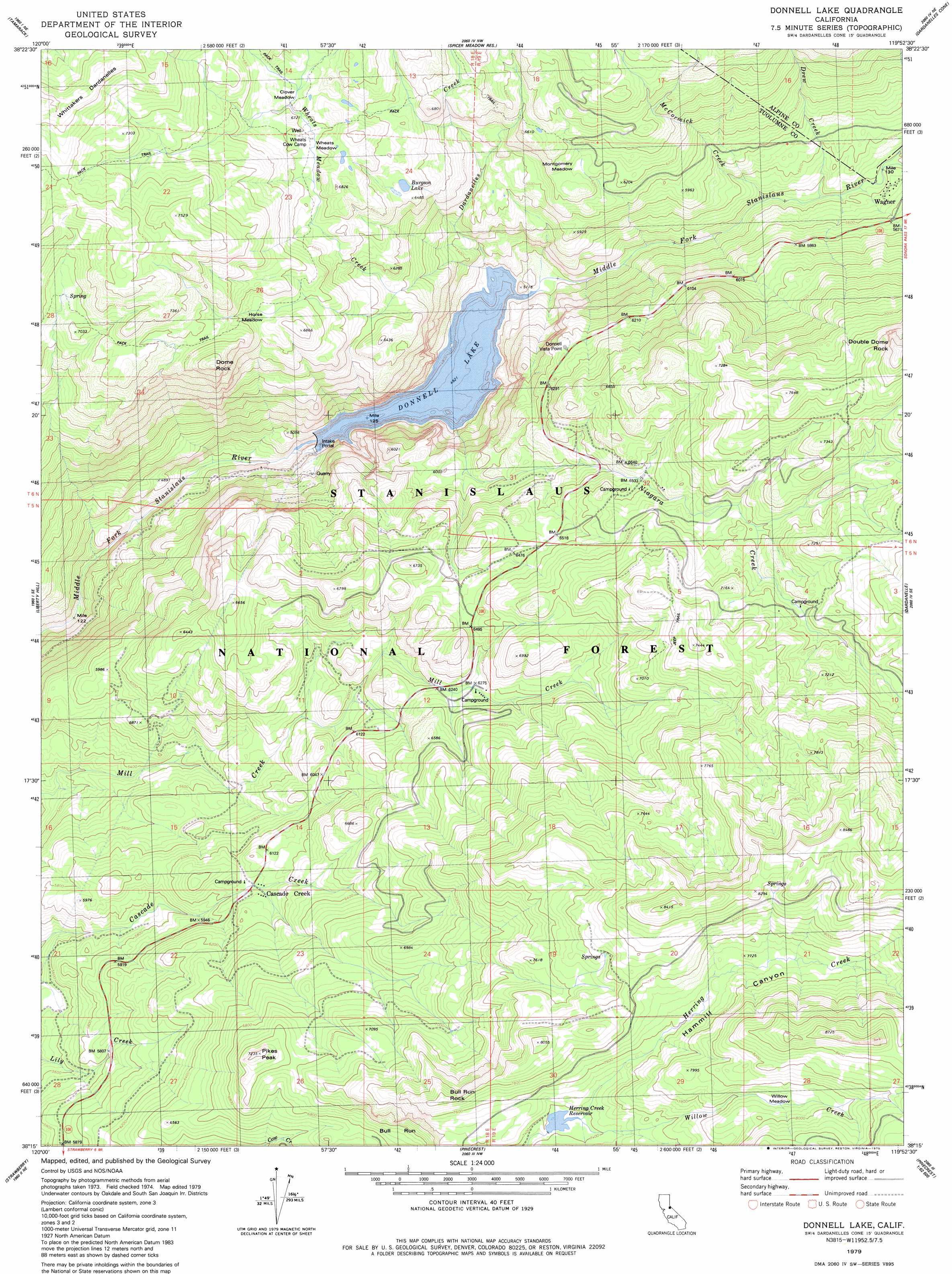
Donnell Lake Topo Map California
To zoom in, hover over the map of Donnell Lake
USGS Topo Quad 38119c8 - 1:24,000 scale
| Topo Map Name: | Donnell Lake |
| USGS Topo Quad ID: | 38119c8 |
| Print Size: | ca. 21 1/4" wide x 27" high |
| Southeast Coordinates: | 38.25° N latitude / 119.875° W longitude |
| Map Center Coordinates: | 38.3125° N latitude / 119.9375° W longitude |
| U.S. State: | CA |
| Filename: | o38119c8.jpg |
| Download Map JPG Image: | Donnell Lake topo map 1:24,000 scale |
| Map Type: | Topographic |
| Topo Series: | 7.5´ |
| Map Scale: | 1:24,000 |
| Source of Map Images: | United States Geological Survey (USGS) |
| Alternate Map Versions: |
Donnell Lake CA 1979, updated 1979 Download PDF Buy paper map Donnell Lake CA 1979, updated 1979 Download PDF Buy paper map Donnell Lake CA 1979, updated 1979 Download PDF Buy paper map Donnell Lake CA 2001, updated 2004 Download PDF Buy paper map Donnell Lake CA 2012 Download PDF Buy paper map Donnell Lake CA 2015 Download PDF Buy paper map |
| FStopo: | US Forest Service topo Donnell Lake is available: Download FStopo PDF Download FStopo TIF |
1:24,000 Topo Quads surrounding Donnell Lake
Bear River Reservoir |
Mokelumne Peak |
Pacific Valley |
Ebbetts Pass |
Wolf Creek |
Calaveras Dome |
Tamarack |
Spicer Meadow Res |
Dardanelles Cone |
Disaster Peak |
Boards Crossing |
Liberty Hill |
Donnell Lake |
Dardanelle |
Sonora Pass |
Crandall Peak |
Strawberry |
Pinecrest |
Cooper Peak |
Emigrant Lake |
Twain Harte |
Hull Creek |
Cherry Lake North |
Kibbie Lake |
Tiltill Mountain |
> Back to 38119a1 at 1:100,000 scale
> Back to 38118a1 at 1:250,000 scale
> Back to U.S. Topo Maps home
Donnell Lake topo map: Gazetteer
Donnell Lake: Dams
Donnells 62-005 Dam elevation 1415m 4642′Donnell Lake: Flats
Clover Meadow elevation 2025m 6643′Horse Meadow elevation 2031m 6663′
Montgomery Meadow elevation 1900m 6233′
Wheats Meadow elevation 2007m 6584′
Willow Meadow elevation 2397m 7864′
Donnell Lake: Lakes
Burgson Lake elevation 1962m 6437′Donnell Lake: Populated Places
Wagner elevation 1672m 5485′Donnell Lake: Reservoirs
Donnell Lake elevation 1417m 4648′Herring Creek Reservoir elevation 2251m 7385′
Donnell Lake: Ridges
Whittakers Dardanelles elevation 2382m 7814′Donnell Lake: Streams
Clark Fork elevation 1636m 5367′Dardanelles Creek elevation 1502m 4927′
Drew Creek elevation 1628m 5341′
Fence Creek elevation 1649m 5410′
McCormick Creek elevation 1610m 5282′
Niagara Creek elevation 1520m 4986′
Wheats Meadow Creek elevation 1501m 4924′
Willow Creek elevation 2252m 7388′
Donnell Lake: Summits
Bull Run Rock elevation 2393m 7851′Dome Rock elevation 2235m 7332′
Double Dome Rock elevation 2401m 7877′
Pikes Peak elevation 2205m 7234′
Donnell Lake: Tunnels
Donnell Tunnel elevation 1800m 5905′Donnell Lake: Valleys
Hammill Canyon elevation 2251m 7385′Donnell Lake digital topo map on disk
Buy this Donnell Lake topo map showing relief, roads, GPS coordinates and other geographical features, as a high-resolution digital map file on DVD: