Dardanelles Cone Topo Map California
To zoom in, hover over the map of Dardanelles Cone
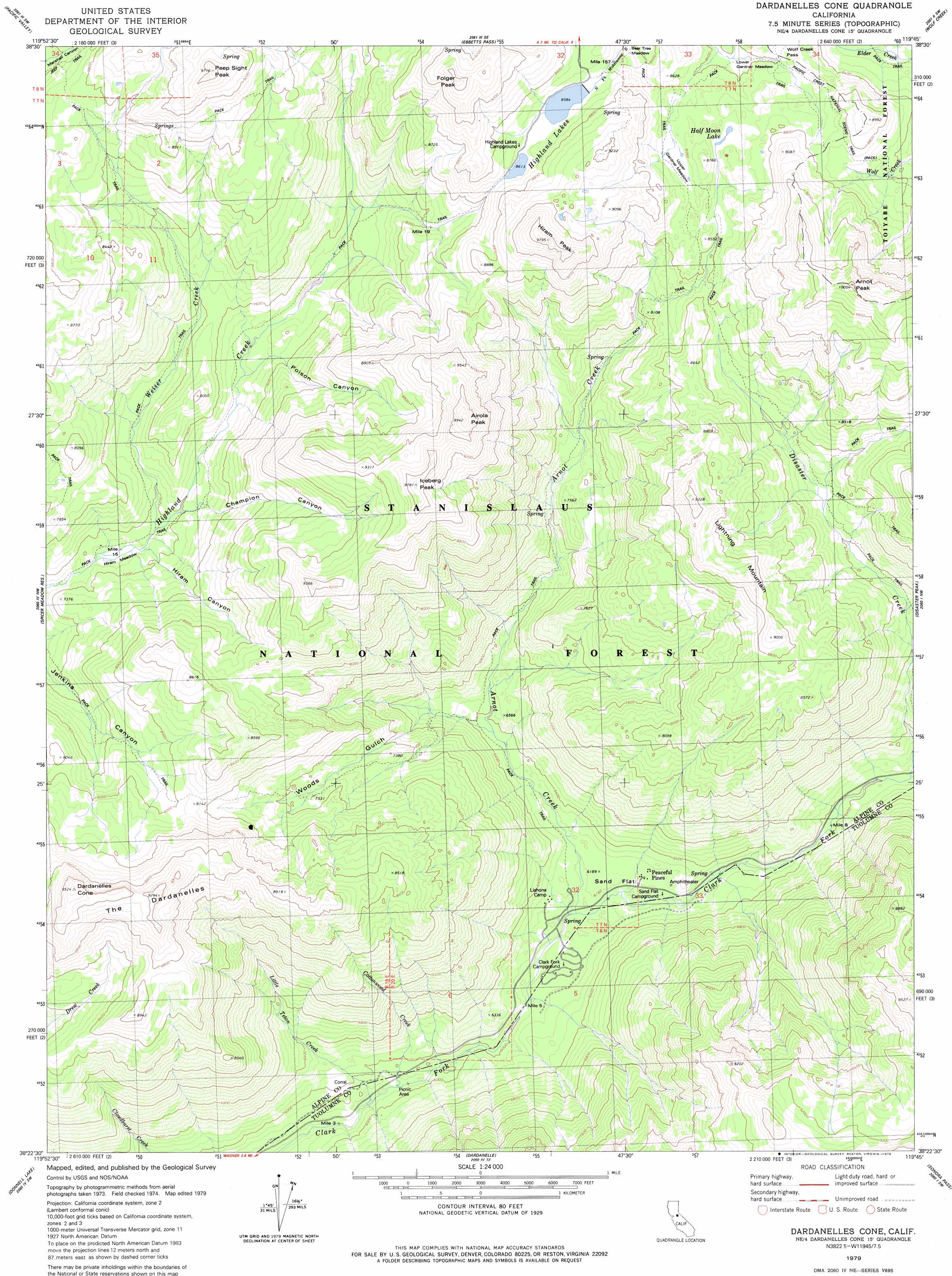
USGS Topo Quad 38119d7 - 1:24,000 scale
| Topo Map Name: | Dardanelles Cone |
| USGS Topo Quad ID: | 38119d7 |
| Print Size: | ca. 21 1/4" wide x 27" high |
| Southeast Coordinates: | 38.375° N latitude / 119.75° W longitude |
| Map Center Coordinates: | 38.4375° N latitude / 119.8125° W longitude |
| U.S. State: | CA |
| Filename: | o38119d7.jpg |
| Download Map JPG Image: | Dardanelles Cone topo map 1:24,000 scale |
| Map Type: | Topographic |
| Topo Series: | 7.5´ |
| Map Scale: | 1:24,000 |
| Source of Map Images: | United States Geological Survey (USGS) |
| Alternate Map Versions: |
Dardanelles Cone CA 1979, updated 1979 Download PDF Buy paper map Dardanelles Cone CA 1979, updated 1979 Download PDF Buy paper map Dardanelles Cone CA 2001, updated 2004 Download PDF Buy paper map Dardanelles Cone CA 2012 Download PDF Buy paper map Dardanelles Cone CA 2015 Download PDF Buy paper map |
| FStopo: | US Forest Service topo Dardanelles Cone is available: Download FStopo PDF Download FStopo TIF |
1:24,000 Topo Quads surrounding Dardanelles Cone
Caples Lake |
Carson Pass |
Markleeville |
Heenan Lake |
Topaz Lake |
Mokelumne Peak |
Pacific Valley |
Ebbetts Pass |
Wolf Creek |
Coleville |
Tamarack |
Spicer Meadow Res |
Dardanelles Cone |
Disaster Peak |
Lost Cannon Peak |
Liberty Hill |
Donnell Lake |
Dardanelle |
Sonora Pass |
Pickel Meadow |
Strawberry |
Pinecrest |
Cooper Peak |
Emigrant Lake |
Tower Peak |
> Back to 38119a1 at 1:100,000 scale
> Back to 38118a1 at 1:250,000 scale
> Back to U.S. Topo Maps home
Dardanelles Cone topo map: Gazetteer
Dardanelles Cone: Dams
Lower Highland Dam elevation 2621m 8599′Dardanelles Cone: Flats
Bear Tree Meadow elevation 2618m 8589′Hiram Meadow elevation 2160m 7086′
Lower Gardner Meadow elevation 2558m 8392′
Sand Flat elevation 1879m 6164′
Upper Gardner Meadow elevation 2602m 8536′
Dardanelles Cone: Gaps
Wolf Creek Pass elevation 2576m 8451′Dardanelles Cone: Lakes
Half Moon Lake elevation 2604m 8543′Highland Lakes elevation 2621m 8599′
Dardanelles Cone: Populated Places
Peaceful Pines elevation 1892m 6207′Dardanelles Cone: Streams
Arnot Creek elevation 1866m 6122′Cottonwood Creek elevation 1799m 5902′
Disaster Creek elevation 1972m 6469′
Little Teton Creek elevation 1780m 5839′
Weiser Creek elevation 2171m 7122′
Dardanelles Cone: Summits
Airola Peak elevation 2989m 9806′Arnot Peak elevation 3059m 10036′
Dardanelles Cone elevation 2905m 9530′
Folger Peak elevation 2938m 9639′
Hiram Peak elevation 2948m 9671′
Iceberg Peak elevation 2969m 9740′
Lighting Mountain elevation 2835m 9301′
Peep Sight Peak elevation 2950m 9678′
The Dardanelles elevation 2706m 8877′
Dardanelles Cone: Valleys
Champion Canyon elevation 2193m 7194′Hiram Canyon elevation 2169m 7116′
Poison Canyon elevation 2239m 7345′
Woods Gulch elevation 1943m 6374′
Dardanelles Cone digital topo map on disk
Buy this Dardanelles Cone topo map showing relief, roads, GPS coordinates and other geographical features, as a high-resolution digital map file on DVD: