Pine Grove Spring Topo Map Nevada
To zoom in, hover over the map of Pine Grove Spring
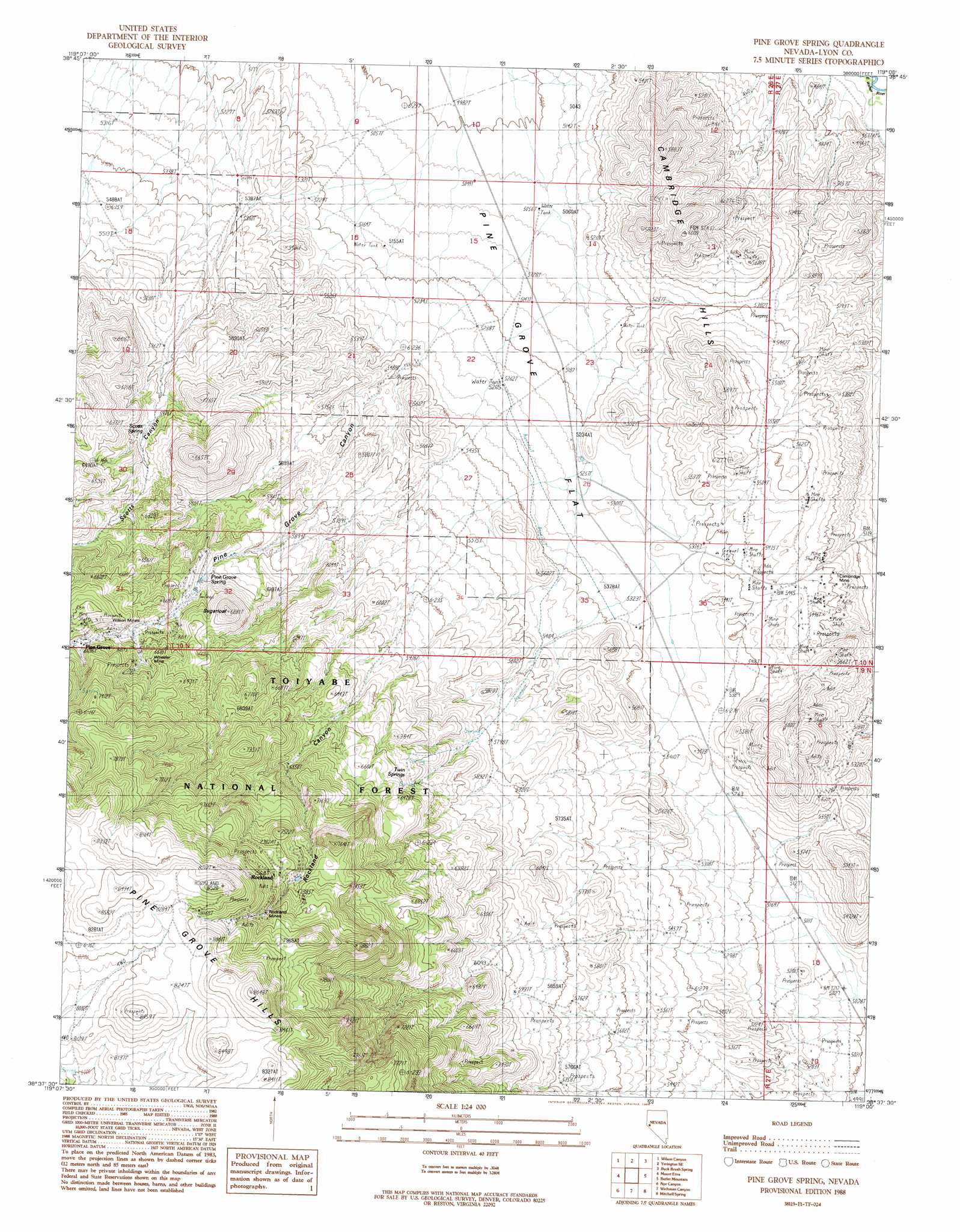
USGS Topo Quad 38119f1 - 1:24,000 scale
| Topo Map Name: | Pine Grove Spring |
| USGS Topo Quad ID: | 38119f1 |
| Print Size: | ca. 21 1/4" wide x 27" high |
| Southeast Coordinates: | 38.625° N latitude / 119° W longitude |
| Map Center Coordinates: | 38.6875° N latitude / 119.0625° W longitude |
| U.S. State: | NV |
| Filename: | o38119f1.jpg |
| Download Map JPG Image: | Pine Grove Spring topo map 1:24,000 scale |
| Map Type: | Topographic |
| Topo Series: | 7.5´ |
| Map Scale: | 1:24,000 |
| Source of Map Images: | United States Geological Survey (USGS) |
| Alternate Map Versions: |
Pine Grove Spring NV 1988, updated 1989 Download PDF Buy paper map Pine Grove Spring NV 2012 Download PDF Buy paper map Pine Grove Spring NV 2014 Download PDF Buy paper map |
| FStopo: | US Forest Service topo Pine Grove Spring is available: Download FStopo PDF Download FStopo TIF |
1:24,000 Topo Quads surrounding Pine Grove Spring
Artesia Lake |
Yerington |
Yerington Ne |
Hussman Spring |
Schurz |
Smith |
Wilson Canyon |
Yerington Se |
Buck Brush Spring |
Reese River Canyon |
Desert Creek Ranch |
Mount Etna |
Pine Grove Spring |
Butler Mountain |
Copper Canyon |
Desert Creek Peak |
Nye Canyon |
Wichman Canyon |
Mitchell Spring |
Mount Grant |
Mount Patterson |
Sweetwater Creek |
The Elbow |
Ninemile Ranch |
Corey Peak |
> Back to 38119e1 at 1:100,000 scale
> Back to 38118a1 at 1:250,000 scale
> Back to U.S. Topo Maps home
Pine Grove Spring topo map: Gazetteer
Pine Grove Spring: Dams
Wheeler Flat Dam elevation 1598m 5242′Pine Grove Spring: Flats
Pine Grove Flat elevation 1535m 5036′Pine Grove Spring: Mines
Cambridge Mine elevation 1633m 5357′Rockland Mines elevation 2374m 7788′
Wheeler Mine elevation 2035m 6676′
Wilson Mines elevation 2027m 6650′
Pine Grove Spring: Populated Places
Cambridge (historical) elevation 1666m 5465′Pine Grove elevation 2047m 6715′
Pine Grove Spring: Post Offices
Cambridge Post Office elevation 1666m 5465′Pine Grove Post Office (historical) elevation 2047m 6715′
Rockland Mine Post Office (historical) elevation 2314m 7591′
Rockland Post Office (historical) elevation 2306m 7565′
Pine Grove Spring: Springs
Pine Grove Spring elevation 1910m 6266′Scotts Spring elevation 1850m 6069′
Twin Springs elevation 1927m 6322′
Webster Summit Spring elevation 1878m 6161′
Webster Water Hole elevation 1695m 5561′
Pine Grove Spring: Summits
Sugarloaf elevation 1996m 6548′Pine Grove Spring: Valleys
Pine Grove Canyon elevation 1688m 5538′Rockland Canyon elevation 1864m 6115′
Scotts Canyon elevation 1637m 5370′
Pine Grove Spring digital topo map on disk
Buy this Pine Grove Spring topo map showing relief, roads, GPS coordinates and other geographical features, as a high-resolution digital map file on DVD: