Carson Pass Topo Map California
To zoom in, hover over the map of Carson Pass
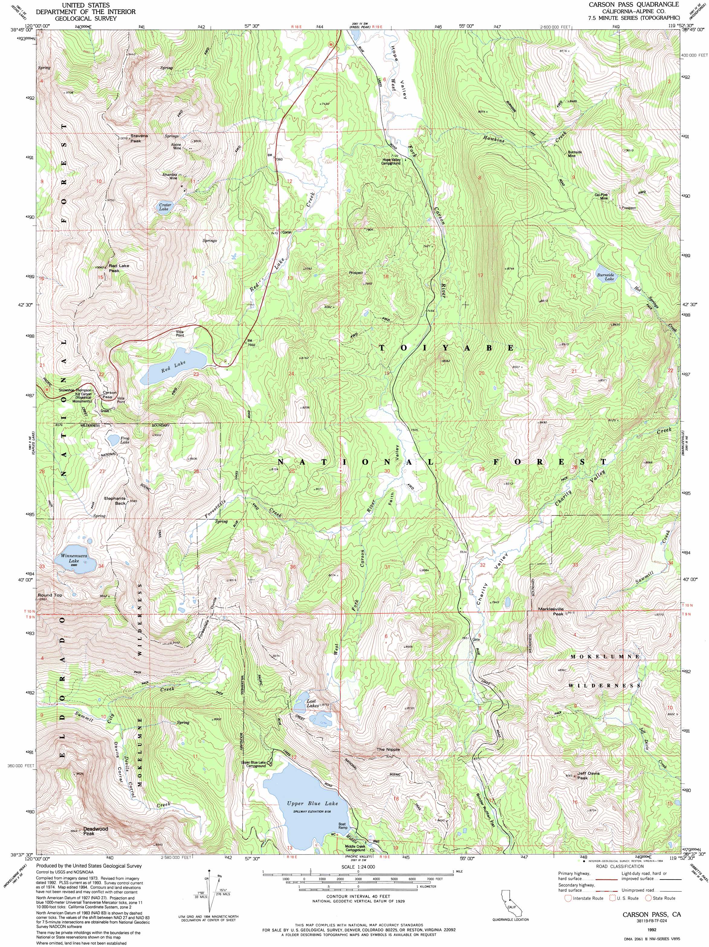
USGS Topo Quad 38119f8 - 1:24,000 scale
| Topo Map Name: | Carson Pass |
| USGS Topo Quad ID: | 38119f8 |
| Print Size: | ca. 21 1/4" wide x 27" high |
| Southeast Coordinates: | 38.625° N latitude / 119.875° W longitude |
| Map Center Coordinates: | 38.6875° N latitude / 119.9375° W longitude |
| U.S. State: | CA |
| Filename: | o38119f8.jpg |
| Download Map JPG Image: | Carson Pass topo map 1:24,000 scale |
| Map Type: | Topographic |
| Topo Series: | 7.5´ |
| Map Scale: | 1:24,000 |
| Source of Map Images: | United States Geological Survey (USGS) |
| Alternate Map Versions: |
Carson Pass CA 1979, updated 1979 Download PDF Buy paper map Carson Pass CA 1979, updated 1979 Download PDF Buy paper map Carson Pass CA 1992, updated 1994 Download PDF Buy paper map Carson Pass CA 1992, updated 1994 Download PDF Buy paper map Carson Pass CA 2012 Download PDF Buy paper map Carson Pass CA 2015 Download PDF Buy paper map |
| FStopo: | US Forest Service topo Carson Pass is available: Download FStopo PDF Download FStopo TIF |
1:24,000 Topo Quads surrounding Carson Pass
Rockbound Valley |
Emerald Bay |
South Lake Tahoe |
Minden |
Gardnerville |
Pyramid Peak |
Echo Lake |
Freel Peak |
Woodfords |
Carters Station |
Tragedy Spring |
Caples Lake |
Carson Pass |
Markleeville |
Heenan Lake |
Bear River Reservoir |
Mokelumne Peak |
Pacific Valley |
Ebbetts Pass |
Wolf Creek |
Calaveras Dome |
Tamarack |
Spicer Meadow Res |
Dardanelles Cone |
Disaster Peak |
> Back to 38119e1 at 1:100,000 scale
> Back to 38118a1 at 1:250,000 scale
> Back to U.S. Topo Maps home
Carson Pass topo map: Gazetteer
Carson Pass: Basins
Devils Corral elevation 2331m 7647′Carson Pass: Dams
Crater Lake 511-002 Dam elevation 2621m 8599′Lost Lake East 512 Dam elevation 2651m 8697′
Lost Lake West 512-002 Dam elevation 2623m 8605′
Red Lake 511-003 Dam elevation 2397m 7864′
Upper Blue Creek 97-070 Dam elevation 2481m 8139′
Carson Pass: Flats
Border Ruffian Flat elevation 2495m 8185′Charity Valley elevation 2384m 7821′
Faith Valley elevation 2293m 7522′
Carson Pass: Gaps
Carson Pass elevation 2619m 8592′Carson Pass: Lakes
Burnside Lake elevation 2482m 8143′Crater Lake elevation 2619m 8592′
Frog Lake elevation 2701m 8861′
Lost Lakes elevation 2623m 8605′
Winnemucca Lake elevation 2738m 8982′
Carson Pass: Mines
Alhambra Mine elevation 2631m 8631′Alpine Mine elevation 2673m 8769′
Brewers Mine elevation 2366m 7762′
Burnside Mine elevation 2487m 8159′
Cal-Pine Mine elevation 2575m 8448′
Carson Pass: Parks
Snowshoe Thompson Historical Monument elevation 2611m 8566′Carson Pass: Pillars
Kit Carson elevation 2615m 8579′Carson Pass: Reservoirs
Red Lake elevation 2397m 7864′Upper Blue Lake elevation 2480m 8136′
Carson Pass: Ridges
Forestdale Divide elevation 2716m 8910′Carson Pass: Streams
Devils Creek elevation 2292m 7519′Forestdale Creek elevation 2299m 7542′
Hawkins Creek elevation 2172m 7125′
Red Lake Creek elevation 2172m 7125′
Carson Pass: Summits
Deadwood Peak elevation 2987m 9799′Elephants Back elevation 2920m 9580′
Jeff Davis Peak elevation 2708m 8884′
Markleeville Peak elevation 2864m 9396′
Red Lake Peak elevation 3060m 10039′
Stevens Peak elevation 3061m 10042′
The Nipple elevation 2847m 9340′
Carson Pass: Trails
Charity Valley Trail elevation 2340m 7677′Carson Pass digital topo map on disk
Buy this Carson Pass topo map showing relief, roads, GPS coordinates and other geographical features, as a high-resolution digital map file on DVD: