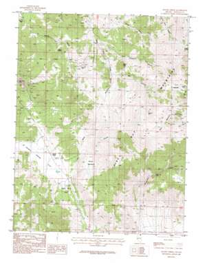
Double Spring Topo Map Nevada
To zoom in, hover over the map of Double Spring
USGS Topo Quad 38119g5 - 1:24,000 scale
| Topo Map Name: | Double Spring |
| USGS Topo Quad ID: | 38119g5 |
| Print Size: | ca. 21 1/4" wide x 27" high |
| Southeast Coordinates: | 38.75° N latitude / 119.5° W longitude |
| Map Center Coordinates: | 38.8125° N latitude / 119.5625° W longitude |
| U.S. State: | NV |
| Filename: | o38119g5.jpg |
| Download Map JPG Image: | Double Spring topo map 1:24,000 scale |
| Map Type: | Topographic |
| Topo Series: | 7.5´ |
| Map Scale: | 1:24,000 |
| Source of Map Images: | United States Geological Survey (USGS) |
| Alternate Map Versions: |
Double Spring NV 1986, updated 1987 Download PDF Buy paper map Double Spring NV 2012 Download PDF Buy paper map Double Spring NV 2014 Download PDF Buy paper map |
| FStopo: | US Forest Service topo Double Spring is available: Download FStopo PDF Download FStopo TIF |
1:24,000 Topo Quads surrounding Double Spring
> Back to 38119e1 at 1:100,000 scale
> Back to 38118a1 at 1:250,000 scale
> Back to U.S. Topo Maps home
Double Spring topo map: Gazetteer
Double Spring: Basins
Carter Canyon elevation 1825m 5987′Double Spring: Flats
Brown Meadows elevation 2009m 6591′Dead Horse Flat elevation 1830m 6003′
Double Spring Flat elevation 1805m 5921′
Double Spring: Gaps
Galena Summit elevation 2589m 8494′Simee Dimeh Summit elevation 1822m 5977′
Double Spring: Mines
Alpine Mine elevation 1926m 6318′B and C Tungsten Mine elevation 1882m 6174′
Carson Valley Tungsten Mine elevation 2013m 6604′
Danite Mine elevation 1837m 6026′
Duval Mine elevation 2049m 6722′
Gold Bug Mine elevation 2643m 8671′
Knox and Nixon Shaft elevation 2727m 8946′
Little Comstock Mine elevation 1810m 5938′
Longfellow Mine elevation 2717m 8914′
Mammoth Mine elevation 1818m 5964′
Monitor Mine elevation 1810m 5938′
Nevada Tungsten Mine elevation 2120m 6955′
Orpheus Mine elevation 1810m 5938′
Payday Tunnel elevation 2655m 8710′
Pikes Peak Mine elevation 2082m 6830′
Pine Nut Consolidated Mine elevation 2068m 6784′
Preachers Mine elevation 1747m 5731′
Premier Mine elevation 2630m 8628′
Red Cloud Shaft elevation 2680m 8792′
Ruby Hill Mine elevation 2101m 6893′
Tungsten Mine elevation 1882m 6174′
Ventura Mine elevation 1810m 5938′
Veta Grande Mine elevation 1905m 6250′
Double Spring: Populated Places
Carman Heights elevation 2716m 8910′Double Springs (historical) elevation 1814m 5951′
Mammoth Ledge (historical) elevation 1803m 5915′
Double Spring: Post Offices
Mammoth Ledge Post Office (historical) elevation 1803m 5915′Sprague Post Office (historical) elevation 1814m 5951′
Double Spring: Ridges
Bald Mountain elevation 2783m 9130′Double Spring: Springs
Buffalo Spring elevation 1952m 6404′Double Spring elevation 1818m 5964′
Double Spring: Summits
Granite Peak elevation 2769m 9084′Rattlesnake Hill elevation 2749m 9019′
Sugar Loaf elevation 2307m 7568′
Double Spring: Valleys
Blossom Canyon elevation 2098m 6883′Buffalo Canyon elevation 1769m 5803′
Mill Canyon elevation 2100m 6889′
Minnehaha Canyon elevation 1724m 5656′
Thompson Canyon elevation 1961m 6433′
Water Canyon elevation 1879m 6164′
Double Spring digital topo map on disk
Buy this Double Spring topo map showing relief, roads, GPS coordinates and other geographical features, as a high-resolution digital map file on DVD:


