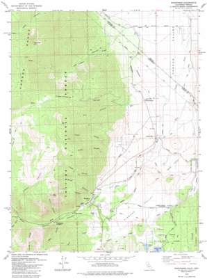
Woodfords Topo Map California
To zoom in, hover over the map of Woodfords
USGS Topo Quad 38119g7 - 1:24,000 scale
| Topo Map Name: | Woodfords |
| USGS Topo Quad ID: | 38119g7 |
| Print Size: | ca. 21 1/4" wide x 27" high |
| Southeast Coordinates: | 38.75° N latitude / 119.75° W longitude |
| Map Center Coordinates: | 38.8125° N latitude / 119.8125° W longitude |
| U.S. States: | CA, NV |
| Filename: | o38119g7.jpg |
| Download Map JPG Image: | Woodfords topo map 1:24,000 scale |
| Map Type: | Topographic |
| Topo Series: | 7.5´ |
| Map Scale: | 1:24,000 |
| Source of Map Images: | United States Geological Survey (USGS) |
| Alternate Map Versions: |
Woodfords CA 1979, updated 1984 Download PDF Buy paper map Woodfords CA 1979, updated 1984 Download PDF Buy paper map Woodfords CA 2012 Download PDF Buy paper map Woodfords CA 2015 Download PDF Buy paper map |
| FStopo: | US Forest Service topo Woodfords is available: Download FStopo PDF Download FStopo TIF |
1:24,000 Topo Quads surrounding Woodfords
> Back to 38119e1 at 1:100,000 scale
> Back to 38118a1 at 1:250,000 scale
> Back to U.S. Topo Maps home
Woodfords topo map: Gazetteer
Woodfords: Canals
Diamond Valley Ditch elevation 1673m 5488′Falke and Tillman Ditch elevation 1488m 4881′
Fredericksburg Ditch elevation 1474m 4835′
Millich Ditch elevation 1718m 5636′
Snowshoe Thompson Ditch Number Two elevation 1674m 5492′
Woodfords: Dams
Indian Creek 1062 Dam elevation 1709m 5606′Woodfords: Parks
Snowshoe Thompson Historical Mon elevation 1659m 5442′Woodfords: Populated Places
Alpine Village elevation 1708m 5603′Fredericksburg elevation 1546m 5072′
Mesa Vista elevation 1672m 5485′
Paynesville elevation 1560m 5118′
Valley View (historical) elevation 1493m 4898′
Woodfords elevation 1712m 5616′
Woodfords: Reservoirs
Indian Creek Reservoir elevation 1709m 5606′Stevens Lake elevation 1702m 5583′
Woodfords: Streams
Luther Creek elevation 1463m 4799′Scott Creek elevation 1732m 5682′
West Fork Carson River elevation 1456m 4776′
Woodfords: Summits
Cary Peak elevation 2651m 8697′Jobs Peak elevation 3233m 10606′
Woodfords: Valleys
Acorn Canyon elevation 1781m 5843′Cary Canyon elevation 1720m 5643′
Cloudburst Canyon elevation 1867m 6125′
Deep Canyon elevation 1949m 6394′
Diamond Valley elevation 1669m 5475′
Dry Canyon elevation 1545m 5068′
Fay Canyon elevation 1463m 4799′
Fay Canyon elevation 1579m 5180′
Fredericksburg Canyon elevation 1502m 4927′
Larson Canyon elevation 1585m 5200′
Merk Canyon elevation 1789m 5869′
Scossa Canyon elevation 1658m 5439′
Stuard Canyon elevation 1619m 5311′
Voight Canyon elevation 1666m 5465′
Wade Canyon elevation 1720m 5643′
Wade Valley elevation 1587m 5206′
West Carson Canyon elevation 1710m 5610′
Woodfords digital topo map on disk
Buy this Woodfords topo map showing relief, roads, GPS coordinates and other geographical features, as a high-resolution digital map file on DVD:


