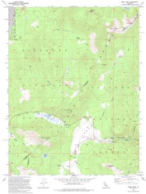
Freel Peak Topo Map California
To zoom in, hover over the map of Freel Peak
USGS Topo Quad 38119g8 - 1:24,000 scale
| Topo Map Name: | Freel Peak |
| USGS Topo Quad ID: | 38119g8 |
| Print Size: | ca. 21 1/4" wide x 27" high |
| Southeast Coordinates: | 38.75° N latitude / 119.875° W longitude |
| Map Center Coordinates: | 38.8125° N latitude / 119.9375° W longitude |
| U.S. State: | CA |
| Filename: | o38119g8.jpg |
| Download Map JPG Image: | Freel Peak topo map 1:24,000 scale |
| Map Type: | Topographic |
| Topo Series: | 7.5´ |
| Map Scale: | 1:24,000 |
| Source of Map Images: | United States Geological Survey (USGS) |
| Alternate Map Versions: |
Freel Peak CA 1955, updated 1956 Download PDF Buy paper map Freel Peak CA 1955, updated 1961 Download PDF Buy paper map Freel Peak CA 1955, updated 1971 Download PDF Buy paper map Freel Peak CA 1955, updated 1983 Download PDF Buy paper map Freel Peak CA 1992, updated 1994 Download PDF Buy paper map Freel Peak CA 1992, updated 1994 Download PDF Buy paper map Freel Peak CA 2012 Download PDF Buy paper map Freel Peak CA 2015 Download PDF Buy paper map |
| FStopo: | US Forest Service topo Freel Peak is available: Download FStopo PDF Download FStopo TIF |
1:24,000 Topo Quads surrounding Freel Peak
> Back to 38119e1 at 1:100,000 scale
> Back to 38118a1 at 1:250,000 scale
> Back to U.S. Topo Maps home
Freel Peak topo map: Gazetteer
Freel Peak: Basins
Hope Valley elevation 2159m 7083′Freel Peak: Dams
Scott Lake 511 Dam elevation 2445m 8021′Freel Peak: Flats
Big Meadow elevation 2294m 7526′Free Meadows elevation 2824m 9265′
Horse Meadow elevation 2590m 8497′
Tucker Flat elevation 2649m 8690′
Freel Peak: Gaps
Armstrong Pass elevation 2657m 8717′Luther Pass elevation 2355m 7726′
Freel Peak: Lakes
Grass Lake elevation 2348m 7703′Scotts Lake elevation 2445m 8021′
Freel Peak: Populated Places
Fountain Place elevation 2373m 7785′Sorensens elevation 2109m 6919′
Freel Peak: Reservoirs
Scotts Lake elevation 2445m 8021′Freel Peak: Streams
Maxwell Creek elevation 2167m 7109′Willow Creek elevation 2152m 7060′
Freel Peak: Summits
Freel Peak elevation 3305m 10843′Jobs Sister elevation 3299m 10823′
Pickett Peak elevation 2743m 8999′
Thompson Peak elevation 2840m 9317′
Trimmer Peak elevation 3016m 9895′
Waterhouse Peak elevation 2875m 9432′
Freel Peak: Swamps
Hell Hole elevation 2552m 8372′Freel Peak: Valleys
Hidden Canyon elevation 1972m 6469′Horsethief Canyon elevation 2418m 7933′
Freel Peak digital topo map on disk
Buy this Freel Peak topo map showing relief, roads, GPS coordinates and other geographical features, as a high-resolution digital map file on DVD:


