Twain Harte Topo Map California
To zoom in, hover over the map of Twain Harte
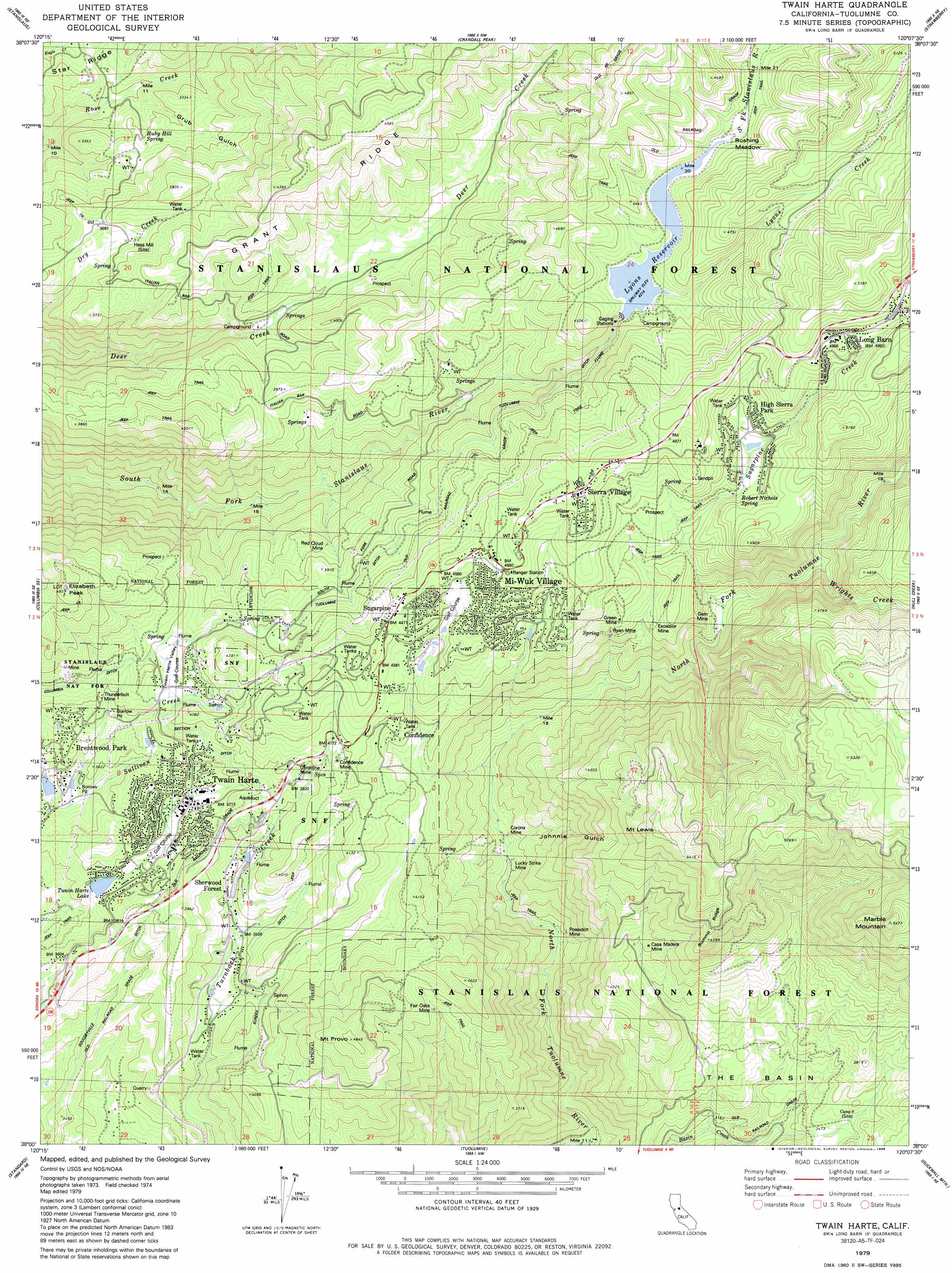
USGS Topo Quad 38120a2 - 1:24,000 scale
| Topo Map Name: | Twain Harte |
| USGS Topo Quad ID: | 38120a2 |
| Print Size: | ca. 21 1/4" wide x 27" high |
| Southeast Coordinates: | 38° N latitude / 120.125° W longitude |
| Map Center Coordinates: | 38.0625° N latitude / 120.1875° W longitude |
| U.S. State: | CA |
| Filename: | o38120a2.jpg |
| Download Map JPG Image: | Twain Harte topo map 1:24,000 scale |
| Map Type: | Topographic |
| Topo Series: | 7.5´ |
| Map Scale: | 1:24,000 |
| Source of Map Images: | United States Geological Survey (USGS) |
| Alternate Map Versions: |
Twain Harte CA 1979, updated 1980 Download PDF Buy paper map Twain Harte CA 1979, updated 1988 Download PDF Buy paper map Twain Harte CA 1979, updated 1988 Download PDF Buy paper map Twain Harte CA 2001, updated 2004 Download PDF Buy paper map Twain Harte CA 2001, updated 2004 Download PDF Buy paper map Twain Harte CA 2012 Download PDF Buy paper map Twain Harte CA 2015 Download PDF Buy paper map |
| FStopo: | US Forest Service topo Twain Harte is available: Download FStopo PDF Download FStopo TIF |
1:24,000 Topo Quads surrounding Twain Harte
Fort Mountain |
Dorrington |
Boards Crossing |
Liberty Hill |
Donnell Lake |
Murphys |
Stanislaus |
Crandall Peak |
Strawberry |
Pinecrest |
Columbia |
Columbia Se |
Twain Harte |
Hull Creek |
Cherry Lake North |
Sonora |
Standard |
Tuolumne |
Duckwall Mountain |
Cherry Lake South |
Chinese Camp |
Moccasin |
Groveland |
Jawbone Ridge |
Ascension Mountain |
> Back to 38120a1 at 1:100,000 scale
> Back to 38120a1 at 1:250,000 scale
> Back to U.S. Topo Maps home
Twain Harte topo map: Gazetteer
Twain Harte: Basins
The Basin elevation 978m 3208′Twain Harte Valley elevation 1193m 3914′
Twain Harte: Canals
Main Tuolumne Ditch elevation 1255m 4117′Soulsbyville Ditch elevation 1011m 3316′
Twain Harte: Dams
Brentwood Park 555 Dam elevation 1086m 3562′Lyons 97-073 Dam elevation 1285m 4215′
Twaine Harte 551 Dam elevation 1060m 3477′
Twain Harte: Flats
Rushing Meadow elevation 1320m 4330′Twain Harte: Mines
Casa Madera Mine elevation 1210m 3969′Confidence Mine elevation 1281m 4202′
Corona Mine elevation 928m 3044′
Excelsior Mine elevation 1303m 4274′
Fair Oaks Mine elevation 1215m 3986′
Gem Mine elevation 1186m 3891′
Geraldine Mine elevation 1185m 3887′
Green Mine elevation 1320m 4330′
Lucky Strike Mine elevation 971m 3185′
Poseidon Mine elevation 915m 3001′
Red Cloud Mine elevation 1078m 3536′
Ryan Mine elevation 1268m 4160′
Thunderbolt Mine elevation 1159m 3802′
Twain Harte: Parks
Odd Fellows High Sierra Park elevation 1415m 4642′Twain Harte: Populated Places
Black Oak Estates elevation 1137m 3730′Brentwood Park elevation 1113m 3651′
Camp Earnest elevation 1036m 3398′
Cedar Pines Vista elevation 1168m 3832′
Cedar Rock Lodge elevation 1099m 3605′
Confidence elevation 1264m 4146′
Hess Mill elevation 1073m 3520′
High Sierra Park elevation 1420m 4658′
Lakewood Highlands elevation 1290m 4232′
Lakewood Park elevation 1323m 4340′
Lilac Terrace elevation 1121m 3677′
Long Barn elevation 1528m 5013′
Lynnwood Estates elevation 1134m 3720′
Mi-Wuk Village elevation 1426m 4678′
Sherwood Forest elevation 1103m 3618′
Sierra Village elevation 1478m 4849′
Sugarpine elevation 1362m 4468′
Sylvan Lodge elevation 1511m 4957′
Tall Timber Camp elevation 1484m 4868′
Twain Harte elevation 1112m 3648′
Twain Harte Valley elevation 1198m 3930′
Twain Harte: Post Offices
Twain Harte Post Office elevation 1112m 3648′Twain Harte: Reservoirs
Lakewood Park Lake elevation 1208m 3963′Lyons Reservoir elevation 1285m 4215′
Twain Harte: Ridges
Grant Ridge elevation 1229m 4032′Star Ridge elevation 1011m 3316′
Summit Ridge elevation 1515m 4970′
Twain Harte: Springs
Robert Nichols Spring elevation 1372m 4501′Ruby Hill Spring elevation 976m 3202′
Twain Harte: Streams
Lyons Creek elevation 1290m 4232′Sugarpine Creek elevation 1167m 3828′
Wrights Creek elevation 1230m 4035′
Twain Harte: Summits
Elizabeth Peak elevation 1486m 4875′Marble Mountain elevation 1665m 5462′
Mount Lewis elevation 1661m 5449′
Mount Provo elevation 1480m 4855′
Twain Harte: Trails
Twain Harte Horseman Trail elevation 1095m 3592′Twain Harte: Valleys
Grub Gulch elevation 911m 2988′Johnnie Gulch elevation 923m 3028′
Twain Harte digital topo map on disk
Buy this Twain Harte topo map showing relief, roads, GPS coordinates and other geographical features, as a high-resolution digital map file on DVD: