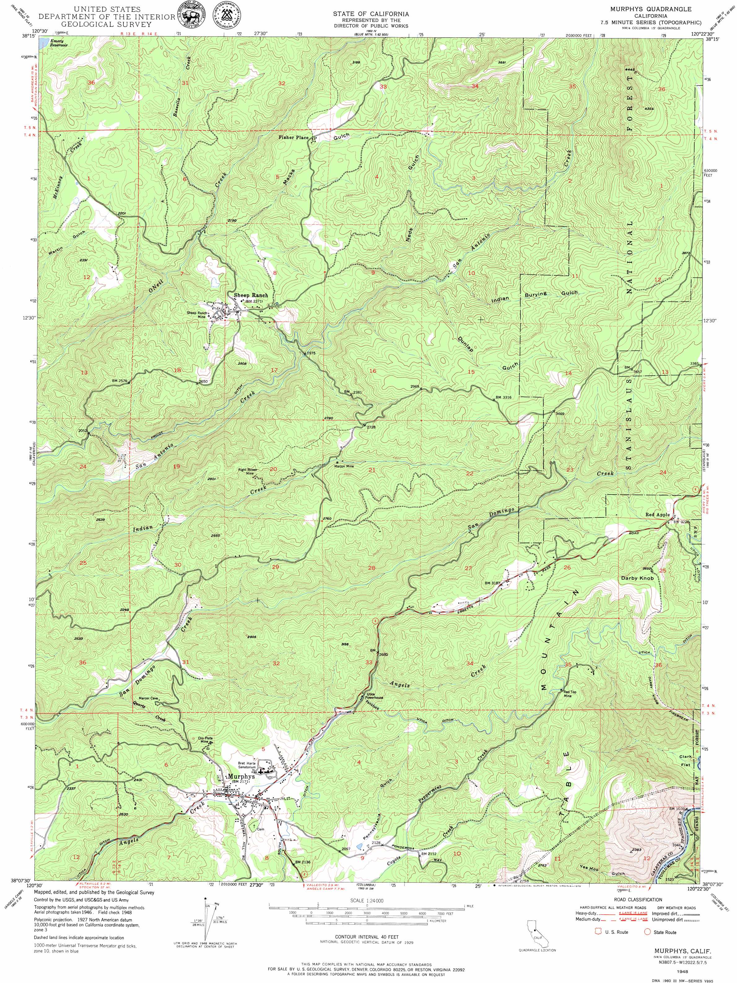
Murphys Topo Map California
To zoom in, hover over the map of Murphys
USGS Topo Quad 38120b4 - 1:24,000 scale
| Topo Map Name: | Murphys |
| USGS Topo Quad ID: | 38120b4 |
| Print Size: | ca. 21 1/4" wide x 27" high |
| Southeast Coordinates: | 38.125° N latitude / 120.375° W longitude |
| Map Center Coordinates: | 38.1875° N latitude / 120.4375° W longitude |
| U.S. State: | CA |
| Filename: | o38120b4.jpg |
| Download Map JPG Image: | Murphys topo map 1:24,000 scale |
| Map Type: | Topographic |
| Topo Series: | 7.5´ |
| Map Scale: | 1:24,000 |
| Source of Map Images: | United States Geological Survey (USGS) |
| Alternate Map Versions: |
Murphys CA 1948, updated 1957 Download PDF Buy paper map Murphys CA 1948, updated 1970 Download PDF Buy paper map Murphys CA 1948, updated 1979 Download PDF Buy paper map Murphys CA 1949, updated 1949 Download PDF Buy paper map Murphys CA 2001, updated 2004 Download PDF Buy paper map Murphys CA 2012 Download PDF Buy paper map Murphys CA 2015 Download PDF Buy paper map |
| FStopo: | US Forest Service topo Murphys is available: Download FStopo PDF Download FStopo TIF |
1:24,000 Topo Quads surrounding Murphys
Pine Grove |
West Point |
Devils Nose |
Garnet Hill |
Calaveras Dome |
Mokelumne Hill |
Rail Road Flat |
Fort Mountain |
Dorrington |
Boards Crossing |
San Andreas |
Calaveritas |
Murphys |
Stanislaus |
Crandall Peak |
Salt Spring Valley |
Angels Camp |
Columbia |
Columbia Se |
Twain Harte |
Copperopolis |
New Melones Dam |
Sonora |
Standard |
Tuolumne |
> Back to 38120a1 at 1:100,000 scale
> Back to 38120a1 at 1:250,000 scale
> Back to U.S. Topo Maps home
Murphys topo map: Gazetteer
Murphys: Canals
Fricot Ditch elevation 674m 2211′Murphys: Dams
Forest Meadows 1495 Dam elevation 959m 3146′Murphys Afterbay 97-117 Dam elevation 699m 2293′
Murphys Forebay 97-127 Dam elevation 916m 3005′
Tanner 1490 Dam elevation 1133m 3717′
Murphys: Flats
Forest Meadow elevation 1112m 3648′Murphys: Mines
Marjon Mine elevation 770m 2526′Oro Plata Mine elevation 701m 2299′
Red Top Mine elevation 924m 3031′
Right Bower Mine elevation 747m 2450′
Sheep Ranch Mine elevation 716m 2349′
Murphys: Parks
Brownsville State Historic Landmark elevation 648m 2125′Murphys Park elevation 655m 2148′
Murphys State Historic Landmark elevation 661m 2168′
Murphys: Populated Places
Big Valley elevation 657m 2155′Cedar Vista elevation 1011m 3316′
Fisher Place elevation 816m 2677′
Forest Meadows elevation 1028m 3372′
Hanford Hill elevation 1001m 3284′
Indian Creek elevation 908m 2979′
Indian Hills elevation 960m 3149′
Murphys elevation 663m 2175′
Red Apple elevation 986m 3234′
Rocky Hill elevation 701m 2299′
Sheep Ranch elevation 719m 2358′
Timber Trails elevation 1102m 3615′
Wyldewood elevation 704m 2309′
Murphys: Post Offices
Murphys Post Office elevation 664m 2178′Murphys: Ridges
Oak RIdge elevation 677m 2221′Murphys: Streams
Bassella Creek elevation 627m 2057′Cowell Creek elevation 750m 2460′
Peppermint Creek elevation 637m 2089′
Quartz Creek elevation 532m 1745′
Murphys: Summits
Darby Knob elevation 1127m 3697′Mineral Mountain elevation 856m 2808′
Murphys: Trails
Darby Knob Firebreak elevation 841m 2759′Timber Trails elevation 1105m 3625′
Murphys: Valleys
Dunlap Gulch elevation 684m 2244′Indian Burying Gulch elevation 695m 2280′
Macks Gulch elevation 596m 1955′
Neds Gulch elevation 690m 2263′
Pennsylvania Gulch elevation 653m 2142′
Murphys digital topo map on disk
Buy this Murphys topo map showing relief, roads, GPS coordinates and other geographical features, as a high-resolution digital map file on DVD: