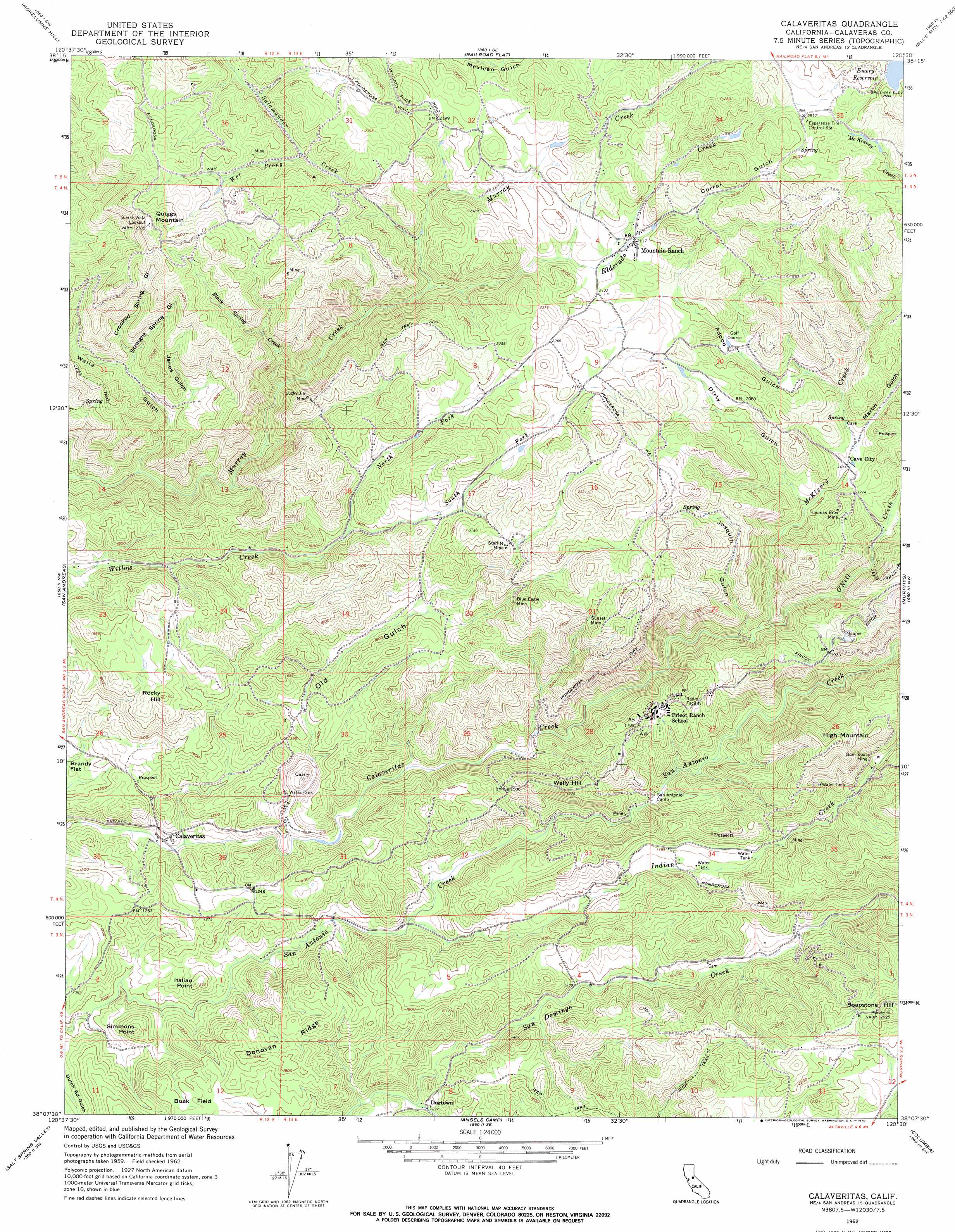
Calaveritas Topo Map California
To zoom in, hover over the map of Calaveritas
USGS Topo Quad 38120b5 - 1:24,000 scale
| Topo Map Name: | Calaveritas |
| USGS Topo Quad ID: | 38120b5 |
| Print Size: | ca. 21 1/4" wide x 27" high |
| Southeast Coordinates: | 38.125° N latitude / 120.5° W longitude |
| Map Center Coordinates: | 38.1875° N latitude / 120.5625° W longitude |
| U.S. State: | CA |
| Filename: | o38120b5.jpg |
| Download Map JPG Image: | Calaveritas topo map 1:24,000 scale |
| Map Type: | Topographic |
| Topo Series: | 7.5´ |
| Map Scale: | 1:24,000 |
| Source of Map Images: | United States Geological Survey (USGS) |
| Alternate Map Versions: |
Calaveritas CA 1962, updated 1963 Download PDF Buy paper map Calaveritas CA 1962, updated 1970 Download PDF Buy paper map Calaveritas CA 1962, updated 1970 Download PDF Buy paper map Calaveritas CA 2012 Download PDF Buy paper map Calaveritas CA 2015 Download PDF Buy paper map |
1:24,000 Topo Quads surrounding Calaveritas
Amador City |
Pine Grove |
West Point |
Devils Nose |
Garnet Hill |
Jackson |
Mokelumne Hill |
Rail Road Flat |
Fort Mountain |
Dorrington |
Valley Springs |
San Andreas |
Calaveritas |
Murphys |
Stanislaus |
Jenny Lind |
Salt Spring Valley |
Angels Camp |
Columbia |
Columbia Se |
Bachelor Valley |
Copperopolis |
New Melones Dam |
Sonora |
Standard |
> Back to 38120a1 at 1:100,000 scale
> Back to 38120a1 at 1:250,000 scale
> Back to U.S. Topo Maps home
Calaveritas topo map: Gazetteer
Calaveritas: Dams
Emery 491 Dam elevation 792m 2598′Calaveritas: Flats
Buck Field elevation 449m 1473′Calaveritas: Mines
Barnhardt Mine elevation 423m 1387′Bence Mine elevation 463m 1519′
Blue Eagle Mine elevation 605m 1984′
Bone Hard Mine elevation 366m 1200′
Bosco Mine elevation 380m 1246′
Bund Mine elevation 441m 1446′
Calaveritas Hill Consolidated Mine elevation 396m 1299′
Chaparral Mine elevation 448m 1469′
Cotton Flat Mine elevation 632m 2073′
Economic Mine elevation 451m 1479′
Esmeralda Mine elevation 539m 1768′
Foley Mine elevation 685m 2247′
Friendship Mine elevation 476m 1561′
Gaston Hill Mine elevation 648m 2125′
Gum Boot Mine elevation 551m 1807′
Hidden Cave Mine elevation 543m 1781′
Humboldt Mine elevation 657m 2155′
Lucky Jim Mine elevation 623m 2043′
Mountain Ranch Mine elevation 674m 2211′
New Orleans Mine elevation 411m 1348′
Oro Fino Mine elevation 444m 1456′
Quarry Four elevation 326m 1069′
Railroad Hill Mine elevation 364m 1194′
Richie Hill Mine elevation 384m 1259′
Rose Hill Mine elevation 684m 2244′
Starlite Mine elevation 638m 2093′
Sunset Mine elevation 622m 2040′
Thomas Brothers Mine elevation 566m 1856′
Calaveritas: Populated Places
Calaveritas elevation 338m 1108′Cave City elevation 493m 1617′
Mountain Ranch elevation 651m 2135′
Calaveritas: Reservoirs
Emery Reservoir elevation 788m 2585′Calaveritas: Ridges
Donovan Ridge elevation 468m 1535′Calaveritas: Streams
Black Spring Creek elevation 452m 1482′Eldorado Creek elevation 546m 1791′
Indian Creek elevation 330m 1082′
McKinney Creek elevation 628m 2060′
North Fork Willow Creek elevation 530m 1738′
O'Neil Creek elevation 422m 1384′
South Fork Willow Creek elevation 530m 1738′
Wet Prong Salamander Creek elevation 609m 1998′
Calaveritas: Summits
High Mountain elevation 748m 2454′Italian Point elevation 385m 1263′
Quiggs Mountain elevation 842m 2762′
Rocky Hill elevation 552m 1811′
Simmons Point elevation 417m 1368′
Soapstone Hill elevation 799m 2621′
Wally Hill elevation 540m 1771′
Calaveritas: Valleys
Adobe Gulch elevation 525m 1722′Corral Gulch elevation 641m 2103′
Crooked Spring Gulch elevation 504m 1653′
Dirty Gulch elevation 474m 1555′
French Gulch elevation 375m 1230′
Janes Gulch elevation 466m 1528′
Joaquin Gulch elevation 415m 1361′
Martin Gulch elevation 495m 1624′
Old Gulch elevation 333m 1092′
Straight Spring Gulch elevation 504m 1653′
Walla Gulch elevation 369m 1210′
Calaveritas digital topo map on disk
Buy this Calaveritas topo map showing relief, roads, GPS coordinates and other geographical features, as a high-resolution digital map file on DVD: