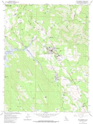
San Andreas Topo Map California
To zoom in, hover over the map of San Andreas
USGS Topo Quad 38120b6 - 1:24,000 scale
| Topo Map Name: | San Andreas |
| USGS Topo Quad ID: | 38120b6 |
| Print Size: | ca. 21 1/4" wide x 27" high |
| Southeast Coordinates: | 38.125° N latitude / 120.625° W longitude |
| Map Center Coordinates: | 38.1875° N latitude / 120.6875° W longitude |
| U.S. State: | CA |
| Filename: | o38120b6.jpg |
| Download Map JPG Image: | San Andreas topo map 1:24,000 scale |
| Map Type: | Topographic |
| Topo Series: | 7.5´ |
| Map Scale: | 1:24,000 |
| Source of Map Images: | United States Geological Survey (USGS) |
| Alternate Map Versions: |
San Andreas CA 1962, updated 1963 Download PDF Buy paper map San Andreas CA 1962, updated 1964 Download PDF Buy paper map San Andreas CA 1962, updated 1964 Download PDF Buy paper map San Andreas CA 2012 Download PDF Buy paper map San Andreas CA 2015 Download PDF Buy paper map |
1:24,000 Topo Quads surrounding San Andreas
> Back to 38120a1 at 1:100,000 scale
> Back to 38120a1 at 1:250,000 scale
> Back to U.S. Topo Maps home
San Andreas topo map: Gazetteer
San Andreas: Airports
Calaveras County Airport elevation 402m 1318′Mark Twain Saint Josephs Hospital Heliport elevation 306m 1003′
San Andreas: Basins
Dry Hollow elevation 537m 1761′San Andreas: Dams
Calaveras Cement 502 Dam elevation 316m 1036′Christensen Number 1 504 Dam elevation 454m 1489′
San Andreas: Flats
Brandy Flat elevation 348m 1141′San Andreas: Mines
Cassinelli Mine elevation 300m 984′Central Hill Mine elevation 317m 1040′
Gold Hill Mine elevation 269m 882′
Hageman Mine elevation 255m 836′
Holland Mine elevation 305m 1000′
Lloyd Mine elevation 352m 1154′
Lookout Mine elevation 248m 813′
Lucky Boy Mine elevation 299m 980′
San Andreas: Parks
Nielsen Park elevation 292m 958′San Andreas: Populated Places
Fourth Crossing elevation 281m 921′Mountain Ranch Subdivision elevation 348m 1141′
Oak Park Estates elevation 343m 1125′
San Andreas elevation 310m 1017′
Toyanza Subdivision elevation 341m 1118′
San Andreas: Post Offices
San Andreas Post Office elevation 291m 954′San Andreas: Reservoirs
Gourley Reservoir elevation 381m 1250′San Andreas: Ridges
Deer Ridge elevation 556m 1824′Hogback Mountain elevation 702m 2303′
San Andreas: Streams
Calaveritas Creek elevation 255m 836′Cedar Creek elevation 241m 790′
Murray Creek elevation 219m 718′
North Fork Calaveras River elevation 215m 705′
North Fork Murray Creek elevation 274m 898′
San Andreas Creek elevation 232m 761′
San Antonio Creek elevation 262m 859′
South Fork Calaveras River elevation 280m 918′
Willow Creek elevation 291m 954′
San Andreas: Summits
Central Hill elevation 460m 1509′Chili Hill elevation 416m 1364′
Deer Peak elevation 582m 1909′
Golden Gate Hill elevation 605m 1984′
Joaquin Peak elevation 854m 2801′
Mount Ophir elevation 376m 1233′
Pine Peak elevation 405m 1328′
San Andreas: Valleys
Chili Gulch elevation 223m 731′Dutch Ed Gulch elevation 292m 958′
Geers Gulch elevation 291m 954′
Latimer Gulch elevation 228m 748′
Old Woman Gulch elevation 268m 879′
Schoolhouse Gulch elevation 279m 915′
Spring Gulch elevation 243m 797′
San Andreas digital topo map on disk
Buy this San Andreas topo map showing relief, roads, GPS coordinates and other geographical features, as a high-resolution digital map file on DVD:


