Valley Springs Topo Map California
To zoom in, hover over the map of Valley Springs
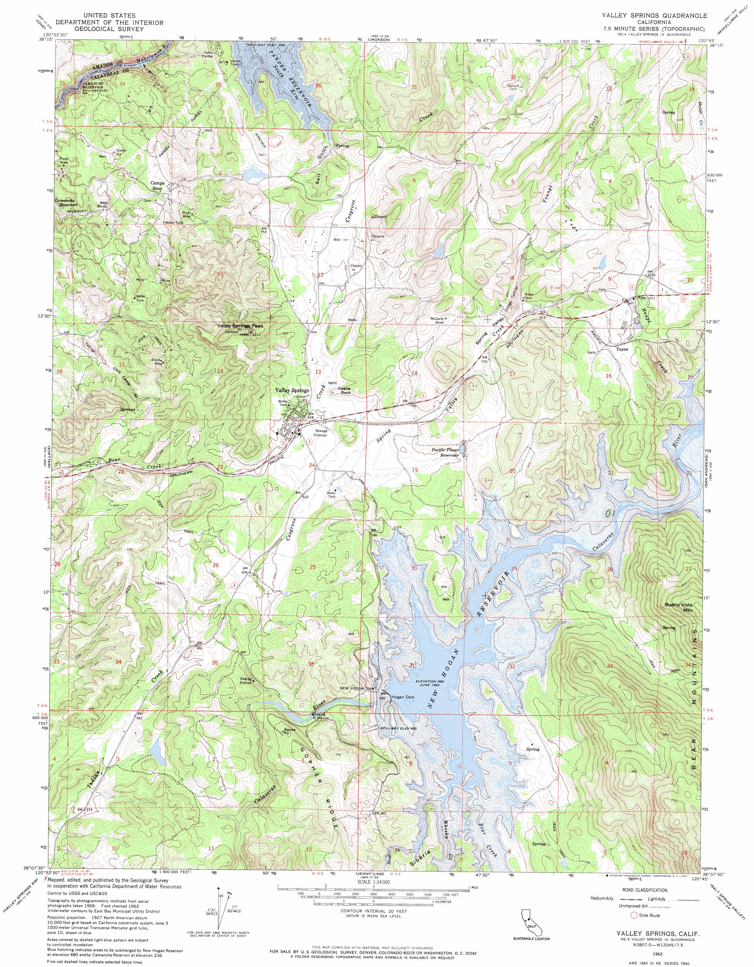
USGS Topo Quad 38120b7 - 1:24,000 scale
| Topo Map Name: | Valley Springs |
| USGS Topo Quad ID: | 38120b7 |
| Print Size: | ca. 21 1/4" wide x 27" high |
| Southeast Coordinates: | 38.125° N latitude / 120.75° W longitude |
| Map Center Coordinates: | 38.1875° N latitude / 120.8125° W longitude |
| U.S. State: | CA |
| Filename: | o38120b7.jpg |
| Download Map JPG Image: | Valley Springs topo map 1:24,000 scale |
| Map Type: | Topographic |
| Topo Series: | 7.5´ |
| Map Scale: | 1:24,000 |
| Source of Map Images: | United States Geological Survey (USGS) |
| Alternate Map Versions: |
Valley Springs CA 1962, updated 1963 Download PDF Buy paper map Valley Springs CA 1962, updated 1969 Download PDF Buy paper map Valley Springs CA 1962, updated 1969 Download PDF Buy paper map Valley Springs CA 2012 Download PDF Buy paper map Valley Springs CA 2015 Download PDF Buy paper map |
1:24,000 Topo Quads surrounding Valley Springs
Carbondale |
Irish Hill |
Amador City |
Pine Grove |
West Point |
Goose Creek |
Ione |
Jackson |
Mokelumne Hill |
Rail Road Flat |
Clements |
Wallace |
Valley Springs |
San Andreas |
Calaveritas |
Linden |
Valley Springs Sw |
Jenny Lind |
Salt Spring Valley |
Angels Camp |
Peters |
Farmington |
Bachelor Valley |
Copperopolis |
New Melones Dam |
> Back to 38120a1 at 1:100,000 scale
> Back to 38120a1 at 1:250,000 scale
> Back to U.S. Topo Maps home
Valley Springs topo map: Gazetteer
Valley Springs: Dams
Hogan Dam elevation 180m 590′New Hogan Dam elevation 203m 666′
Valley Springs: Flats
West Portal elevation 131m 429′Valley Springs: Mines
Emma Mine elevation 184m 603′McCarty Mine elevation 262m 859′
Penn Mine elevation 115m 377′
Pluto Mine elevation 219m 718′
Valley Springs: Parks
Acorn Recreation Area elevation 224m 734′Fiddleneck Day Use Area elevation 238m 780′
Oak Knoll Recreation Area elevation 228m 748′
Valley Springs State Historic Landmark elevation 207m 679′
Wrinkle Cove Day Use Area elevation 230m 754′
Valley Springs: Pillars
Castle Rock elevation 232m 761′Valley Springs: Populated Places
Camp Pardee elevation 212m 695′Campo Seco elevation 172m 564′
Norval (historical) elevation 210m 688′
Quail Oaks elevation 200m 656′
Rancho Calaveras elevation 163m 534′
Toyon elevation 301m 987′
Valley Springs elevation 204m 669′
Valley Springs: Post Offices
Campo Seco Post Office elevation 168m 551′Valley Springs Post Office elevation 206m 675′
Valley Springs: Reservoirs
New Hogan Lake elevation 203m 666′Pacific Placer Reservoir elevation 216m 708′
Valley Springs: Streams
Bear Creek elevation 180m 590′Cosgrove Creek elevation 158m 518′
Haupt Creek elevation 192m 629′
Slate Creek elevation 199m 652′
Spring Valley Creek elevation 189m 620′
Whisky Creek elevation 180m 590′
Youngs Creek elevation 228m 748′
Valley Springs: Summits
Buena Vista Mountain elevation 612m 2007′Valley Springs Peak elevation 357m 1171′
Valley Springs: Tunnels
Pardee Tunnel elevation 235m 770′Valley Springs: Valleys
Chili Camp Gulch elevation 106m 347′Salt Gulch elevation 159m 521′
Spring Valley elevation 221m 725′
Valley Springs digital topo map on disk
Buy this Valley Springs topo map showing relief, roads, GPS coordinates and other geographical features, as a high-resolution digital map file on DVD: