Wallace Topo Map California
To zoom in, hover over the map of Wallace
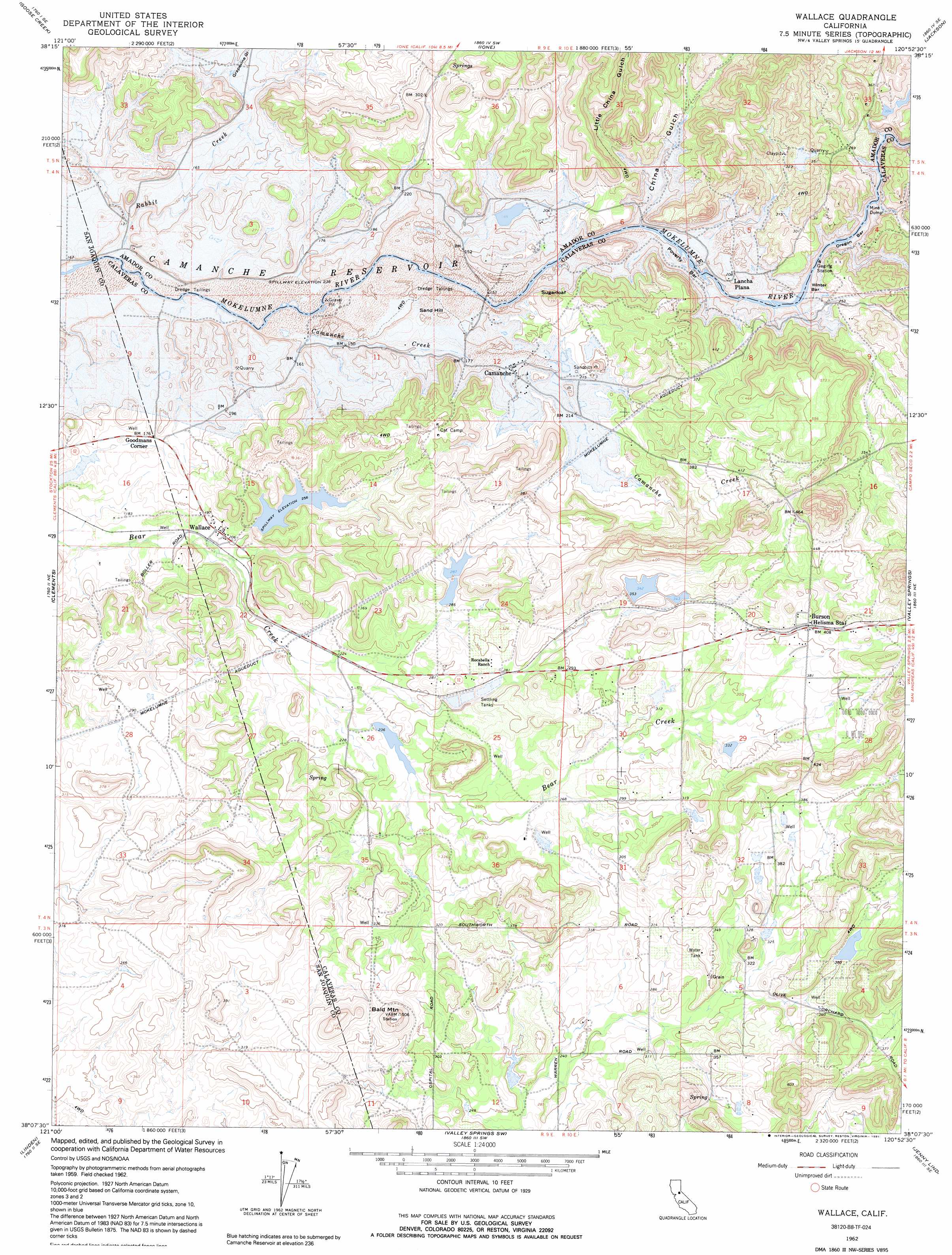
USGS Topo Quad 38120b8 - 1:24,000 scale
| Topo Map Name: | Wallace |
| USGS Topo Quad ID: | 38120b8 |
| Print Size: | ca. 21 1/4" wide x 27" high |
| Southeast Coordinates: | 38.125° N latitude / 120.875° W longitude |
| Map Center Coordinates: | 38.1875° N latitude / 120.9375° W longitude |
| U.S. State: | CA |
| Filename: | o38120b8.jpg |
| Download Map JPG Image: | Wallace topo map 1:24,000 scale |
| Map Type: | Topographic |
| Topo Series: | 7.5´ |
| Map Scale: | 1:24,000 |
| Source of Map Images: | United States Geological Survey (USGS) |
| Alternate Map Versions: |
Wallace CA 1962, updated 1963 Download PDF Buy paper map Wallace CA 1962, updated 1971 Download PDF Buy paper map Wallace CA 1962, updated 1991 Download PDF Buy paper map Wallace CA 2012 Download PDF Buy paper map Wallace CA 2015 Download PDF Buy paper map |
1:24,000 Topo Quads surrounding Wallace
Sloughhouse |
Carbondale |
Irish Hill |
Amador City |
Pine Grove |
Clay |
Goose Creek |
Ione |
Jackson |
Mokelumne Hill |
Lockeford |
Clements |
Wallace |
Valley Springs |
San Andreas |
Waterloo |
Linden |
Valley Springs Sw |
Jenny Lind |
Salt Spring Valley |
Stockton East |
Peters |
Farmington |
Bachelor Valley |
Copperopolis |
> Back to 38120a1 at 1:100,000 scale
> Back to 38120a1 at 1:250,000 scale
> Back to U.S. Topo Maps home
Wallace topo map: Gazetteer
Wallace: Bars
Oregon Bar elevation 54m 177′Poverty Bar elevation 49m 160′
Winter Bar elevation 49m 160′
Wallace: Dams
Bevanda 495 Dam elevation 120m 393′Ferrario 506 Dam elevation 105m 344′
Hein 1491 Dam elevation 82m 269′
Mine Run 31-032 Dam elevation 75m 246′
Wallace: Populated Places
Burson elevation 126m 413′Camanche (historical) elevation 57m 187′
Goodmans Corner elevation 56m 183′
Lake Camanche Ranches elevation 97m 318′
Lancha Plana (historical) elevation 63m 206′
South Camanche Shore elevation 135m 442′
Wallace elevation 58m 190′
Wallace: Post Offices
Burson Post Office elevation 125m 410′Wallace: Streams
Camanche Creek elevation 37m 121′Rabbit Creek elevation 34m 111′
Wallace: Summits
Bald Mountain elevation 153m 501′Sand Hill (historical) elevation 57m 187′
Sugarloaf elevation 102m 334′
Wallace: Valleys
China Gulch elevation 50m 164′Little China Gulch elevation 79m 259′
Wallace digital topo map on disk
Buy this Wallace topo map showing relief, roads, GPS coordinates and other geographical features, as a high-resolution digital map file on DVD: