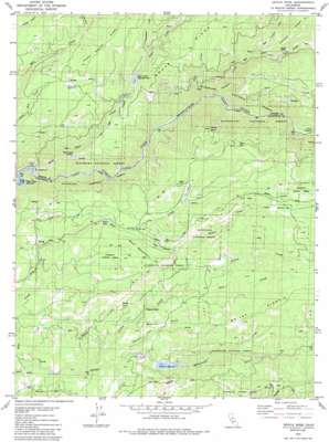
Devils Nose Topo Map California
To zoom in, hover over the map of Devils Nose
USGS Topo Quad 38120d4 - 1:24,000 scale
| Topo Map Name: | Devils Nose |
| USGS Topo Quad ID: | 38120d4 |
| Print Size: | ca. 21 1/4" wide x 27" high |
| Southeast Coordinates: | 38.375° N latitude / 120.375° W longitude |
| Map Center Coordinates: | 38.4375° N latitude / 120.4375° W longitude |
| U.S. State: | CA |
| Filename: | o38120d4.jpg |
| Download Map JPG Image: | Devils Nose topo map 1:24,000 scale |
| Map Type: | Topographic |
| Topo Series: | 7.5´ |
| Map Scale: | 1:24,000 |
| Source of Map Images: | United States Geological Survey (USGS) |
| Alternate Map Versions: |
Devils Nose CA 1979, updated 1979 Download PDF Buy paper map Devils Nose CA 1979, updated 1979 Download PDF Buy paper map Devils Nose CA 1979, updated 1985 Download PDF Buy paper map Devils Nose CA 2001, updated 2004 Download PDF Buy paper map Devils Nose CA 2012 Download PDF Buy paper map Devils Nose CA 2015 Download PDF Buy paper map |
| FStopo: | US Forest Service topo Devils Nose is available: Download FStopo PDF Download FStopo TIF |
1:24,000 Topo Quads surrounding Devils Nose
> Back to 38120a1 at 1:100,000 scale
> Back to 38120a1 at 1:250,000 scale
> Back to U.S. Topo Maps home
Devils Nose topo map: Gazetteer
Devils Nose: Canals
Tiger Creek Conduit elevation 1142m 3746′Devils Nose: Crossings
Bruce Crossing elevation 875m 2870′Devils Nose: Dams
Middle Fork 82-002 Dam elevation 882m 2893′Tiger Creek Forebay 97-126 Dam elevation 1079m 3540′
Tiger Creek Regulator 97-104 Dam elevation 1062m 3484′
West Point Reg 1024-002 Dam elevation 1388m 4553′
Devils Nose: Flats
Boston Flat elevation 949m 3113′Hunter Flat elevation 1313m 4307′
Lily Valley elevation 1172m 3845′
Whitmore Meadow elevation 1171m 3841′
Devils Nose: Gaps
Lily Gap elevation 1116m 3661′Devils Nose: Populated Places
Porter elevation 1087m 3566′Devils Nose: Reservoirs
Schaads Reservoir elevation 887m 2910′Tiger Creek Forbay elevation 1077m 3533′
Tiger Creek Regulation Reservoir elevation 1083m 3553′
Wilson Lake elevation 1096m 3595′
Devils Nose: Ridges
Doaks Ridge elevation 1247m 4091′Devils Nose: Springs
Sugar Spring elevation 1332m 4370′Devils Nose: Streams
Deer Creek elevation 828m 2716′East Panther Creek elevation 1045m 3428′
Forest Creek elevation 814m 2670′
Hunter Creek elevation 973m 3192′
Lion Creek elevation 958m 3143′
Little Tiger Creek elevation 1229m 4032′
Long John Creek elevation 1165m 3822′
Panther Creek elevation 835m 2739′
Sweetwater Creek elevation 1120m 3674′
Tiger Creek elevation 723m 2372′
West Panther Creek elevation 1045m 3428′
Devils Nose: Summits
Bald Mountain elevation 1247m 4091′Devils Nose elevation 1445m 4740′
Devils Nose: Tunnels
Panther Portal elevation 1369m 4491′Devils Nose: Valleys
Boston Flat Gulch elevation 851m 2791′Devils Nose digital topo map on disk
Buy this Devils Nose topo map showing relief, roads, GPS coordinates and other geographical features, as a high-resolution digital map file on DVD:


