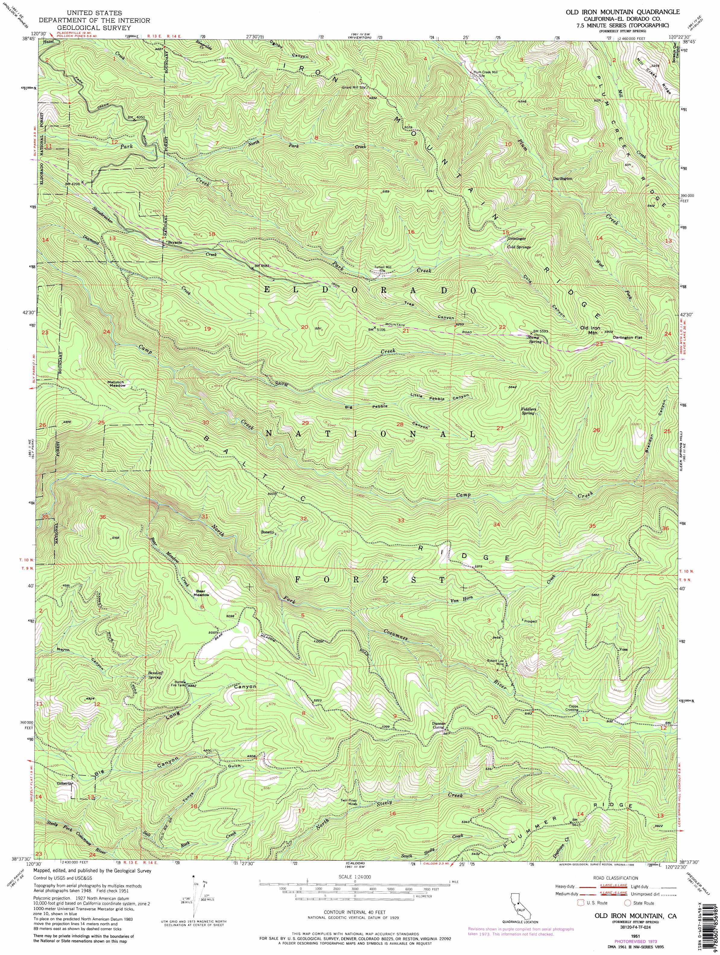
Old Iron Mountain Topo Map California
To zoom in, hover over the map of Old Iron Mountain
USGS Topo Quad 38120f4 - 1:24,000 scale
| Topo Map Name: | Old Iron Mountain |
| USGS Topo Quad ID: | 38120f4 |
| Print Size: | ca. 21 1/4" wide x 27" high |
| Southeast Coordinates: | 38.625° N latitude / 120.375° W longitude |
| Map Center Coordinates: | 38.6875° N latitude / 120.4375° W longitude |
| U.S. State: | CA |
| Filename: | o38120f4.jpg |
| Download Map JPG Image: | Old Iron Mountain topo map 1:24,000 scale |
| Map Type: | Topographic |
| Topo Series: | 7.5´ |
| Map Scale: | 1:24,000 |
| Source of Map Images: | United States Geological Survey (USGS) |
| Alternate Map Versions: |
Stump Spring CA 1951, updated 1952 Download PDF Buy paper map Stump Spring CA 1951, updated 1959 Download PDF Buy paper map Stump Spring CA 1951, updated 1973 Download PDF Buy paper map Stump Spring CA 1951, updated 1974 Download PDF Buy paper map Stump Spring CA 1951, updated 1980 Download PDF Buy paper map Stump Spring CA 1951, updated 1980 Download PDF Buy paper map Stump Spring CA 1951, updated 1987 Download PDF Buy paper map Old Iron Mountain CA 1951, updated 1996 Download PDF Buy paper map Old Iron Mountain CA 2012 Download PDF Buy paper map Old Iron Mountain CA 2015 Download PDF Buy paper map |
| FStopo: | US Forest Service topo Old Iron Mountain is available: Download FStopo PDF Download FStopo TIF |
1:24,000 Topo Quads surrounding Old Iron Mountain
Tunnel Hill |
Devil Peak |
Robbs Peak |
Loon Lake |
Rockbound Valley |
Slate Mountain |
Pollock Pines |
Riverton |
Kyburz |
Pyramid Peak |
Camino |
Sly Park |
Old Iron Mountain |
Leek Spring Hill |
Tragedy Spring |
Aukum |
Omo Ranch |
Caldor |
Peddler Hill |
Bear River Reservoir |
Pine Grove |
West Point |
Devils Nose |
Garnet Hill |
Calaveras Dome |
> Back to 38120e1 at 1:100,000 scale
> Back to 38120a1 at 1:250,000 scale
> Back to U.S. Topo Maps home
Old Iron Mountain topo map: Gazetteer
Old Iron Mountain: Crossings
Capps Crossing elevation 1550m 5085′Old Iron Mountain: Flats
Bear Meadow elevation 1513m 4963′Darlington Flat elevation 1772m 5813′
Matulich Meadow elevation 1366m 4481′
Old Iron Mountain: Mines
Robert Lee Mine elevation 1591m 5219′Twin Pines Mine elevation 1424m 4671′
Old Iron Mountain: Populated Places
Bonetti elevation 1412m 4632′Bryants elevation 1350m 4429′
Darlington elevation 1279m 4196′
Gilberts elevation 1295m 4248′
Griminger elevation 1495m 4904′
Voss elevation 1676m 5498′
Old Iron Mountain: Reservoirs
Harrel Fire Tank elevation 1499m 4917′Old Iron Mountain: Ridges
Iron Mountain Ridge elevation 1571m 5154′Plum Creek Ridge elevation 1640m 5380′
Old Iron Mountain: Springs
Bendorf Spring elevation 1423m 4668′Cold Springs elevation 1496m 4908′
Fiddlers Spring elevation 1582m 5190′
Stump Spring elevation 1691m 5547′
Old Iron Mountain: Streams
Bear Meadow Creek elevation 1204m 3950′North Sly Park Creek elevation 1178m 3864′
Salt Rock Creek elevation 1181m 3874′
Snow Creek elevation 1261m 4137′
Van Horn Creek elevation 1341m 4399′
West Fork Plum Creek elevation 1340m 4396′
Old Iron Mountain: Summits
Old Iron Mountain elevation 1798m 5898′Old Iron Mountain: Valleys
Big Pebble Canyon elevation 1403m 4603′Brandon Canyon elevation 1517m 4977′
Cold Canyon elevation 1488m 4881′
Little Pebble Canyon elevation 1471m 4826′
Long Canyon elevation 1308m 4291′
Tonys Gulch elevation 1327m 4353′
Trap Canyon elevation 1378m 4520′
Old Iron Mountain digital topo map on disk
Buy this Old Iron Mountain topo map showing relief, roads, GPS coordinates and other geographical features, as a high-resolution digital map file on DVD: