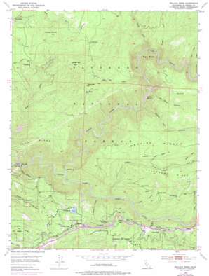
Pollock Pines Topo Map California
To zoom in, hover over the map of Pollock Pines
USGS Topo Quad 38120g5 - 1:24,000 scale
| Topo Map Name: | Pollock Pines |
| USGS Topo Quad ID: | 38120g5 |
| Print Size: | ca. 21 1/4" wide x 27" high |
| Southeast Coordinates: | 38.75° N latitude / 120.5° W longitude |
| Map Center Coordinates: | 38.8125° N latitude / 120.5625° W longitude |
| U.S. State: | CA |
| Filename: | o38120g5.jpg |
| Download Map JPG Image: | Pollock Pines topo map 1:24,000 scale |
| Map Type: | Topographic |
| Topo Series: | 7.5´ |
| Map Scale: | 1:24,000 |
| Source of Map Images: | United States Geological Survey (USGS) |
| Alternate Map Versions: |
Pollock Pines CA 1950, updated 1952 Download PDF Buy paper map Pollock Pines CA 1950, updated 1958 Download PDF Buy paper map Pollock Pines CA 1950, updated 1965 Download PDF Buy paper map Pollock Pines CA 1950, updated 1976 Download PDF Buy paper map Pollock Pines CA 2012 Download PDF Buy paper map Pollock Pines CA 2015 Download PDF Buy paper map |
| FStopo: | US Forest Service topo Pollock Pines is available: Download FStopo PDF Download FStopo TIF |
1:24,000 Topo Quads surrounding Pollock Pines
> Back to 38120e1 at 1:100,000 scale
> Back to 38120a1 at 1:250,000 scale
> Back to U.S. Topo Maps home
Pollock Pines topo map: Gazetteer
Pollock Pines: Airports
Fresh Pond Heliport elevation 1153m 3782′Pacific Gas and Electric Company Camp 5 Heliport elevation 1150m 3772′
Pollock Pines: Canals
El Dorado Irrigation District Main Canal elevation 1139m 3736′Pollock Pines: Dams
Camino 1009-004 Dam elevation 876m 2874′El Dorado Forebay 97-053 Dam elevation 1144m 3753′
Pollock Pines: Flats
Kings Meadow elevation 1362m 4468′Pollock Pines: Parks
Bullion Bend Historic Marker elevation 1216m 3989′Pollock Pines Recreation Park elevation 1170m 3838′
Pollock Pines: Populated Places
Claussenius elevation 1286m 4219′Ditch Camp Five elevation 1171m 3841′
Fresh Pond elevation 1099m 3605′
Gold Ridge elevation 1233m 4045′
McManus elevation 1308m 4291′
Pacific elevation 1035m 3395′
Pollock Pines elevation 1198m 3930′
Spring Valley elevation 1152m 3779′
Van Vleck elevation 1184m 3884′
Pollock Pines: Post Offices
Pollock Pines Post Office elevation 1184m 3884′Pollock Pines: Reservoirs
Brush Creek Reservoir elevation 571m 1873′Camino Reservoir elevation 876m 2874′
Long Canyon Forebay elevation 1146m 3759′
Pollock Pines: Ridges
Poho Ridge elevation 1005m 3297′Telephone Ridge elevation 1370m 4494′
Pollock Pines: Springs
Deadman Spring elevation 1129m 3704′Jay Bird Spring elevation 1407m 4616′
Pollock Pines: Streams
Bear Creek elevation 1178m 3864′Brooks Creek elevation 1094m 3589′
Davis Creek elevation 1009m 3310′
Gasparni Creek elevation 936m 3070′
Incline Creek elevation 971m 3185′
Little Soldier Creek elevation 1222m 4009′
North Fork Soldier Creek elevation 1285m 4215′
Onion Creek elevation 982m 3221′
Silver Creek elevation 628m 2060′
Soldier Creek elevation 752m 2467′
South Fork Soldier Creek elevation 1285m 4215′
Sugar Pine Creek elevation 949m 3113′
Pollock Pines: Summits
Big Bend elevation 1357m 4452′Chaix Mountain elevation 1471m 4826′
Little Sugar Pine Mountain elevation 1492m 4895′
Saddle Mountain elevation 1555m 5101′
Union Hill elevation 1316m 4317′
Pollock Pines: Valleys
Brush Canyon elevation 1005m 3297′Cement Ravine elevation 1274m 4179′
Fresh Pond Ravine elevation 868m 2847′
Grays Canyon elevation 810m 2657′
Jay Bird Canyon elevation 890m 2919′
North Fork Long Canyon elevation 987m 3238′
Randolph Canyon elevation 733m 2404′
Round Tent Canyon elevation 842m 2762′
South Fork Long Canyon elevation 987m 3238′
Pollock Pines digital topo map on disk
Buy this Pollock Pines topo map showing relief, roads, GPS coordinates and other geographical features, as a high-resolution digital map file on DVD:


