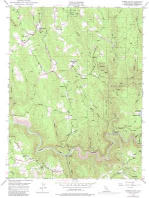
Garden Valley Topo Map California
To zoom in, hover over the map of Garden Valley
USGS Topo Quad 38120g7 - 1:24,000 scale
| Topo Map Name: | Garden Valley |
| USGS Topo Quad ID: | 38120g7 |
| Print Size: | ca. 21 1/4" wide x 27" high |
| Southeast Coordinates: | 38.75° N latitude / 120.75° W longitude |
| Map Center Coordinates: | 38.8125° N latitude / 120.8125° W longitude |
| U.S. State: | CA |
| Filename: | o38120g7.jpg |
| Download Map JPG Image: | Garden Valley topo map 1:24,000 scale |
| Map Type: | Topographic |
| Topo Series: | 7.5´ |
| Map Scale: | 1:24,000 |
| Source of Map Images: | United States Geological Survey (USGS) |
| Alternate Map Versions: |
Garden Valley CA 1949, updated 1959 Download PDF Buy paper map Garden Valley CA 1949, updated 1968 Download PDF Buy paper map Garden Valley CA 1949, updated 1976 Download PDF Buy paper map Garden Valley CA 1949, updated 1984 Download PDF Buy paper map Garden Valley CA 1950, updated 1950 Download PDF Buy paper map Garden Valley CA 2012 Download PDF Buy paper map Garden Valley CA 2015 Download PDF Buy paper map |
| FStopo: | US Forest Service topo Garden Valley is available: Download FStopo PDF Download FStopo TIF |
1:24,000 Topo Quads surrounding Garden Valley
> Back to 38120e1 at 1:100,000 scale
> Back to 38120a1 at 1:250,000 scale
> Back to U.S. Topo Maps home
Garden Valley topo map: Gazetteer
Garden Valley: Airports
Dubey Airport elevation 715m 2345′Garden Valley: Dams
Chili Bar Reservoir elevation 298m 977′Finnon Lake 1-034 Dam elevation 733m 2404′
Manhattan Creek 2461 Dam elevation 632m 2073′
Garden Valley: Flats
Barley Flat elevation 668m 2191′Garden Valley: Mines
Alhambra Mine elevation 682m 2237′Black Oak Mine elevation 613m 2011′
Nancy Lee Mine elevation 570m 1870′
Slate Mine elevation 334m 1095′
Taylor Mine elevation 607m 1991′
Garden Valley: Populated Places
Garden Valley elevation 594m 1948′Gold Trail Park elevation 527m 1729′
Kelsey elevation 586m 1922′
Meadow Brook elevation 694m 2276′
North Placerville elevation 552m 1811′
Spanish Flat elevation 741m 2431′
Garden Valley: Reservoirs
Finnon Reservoir elevation 733m 2404′Oma 6 300 Reservoir elevation 302m 990′
Teal Pond elevation 512m 1679′
Garden Valley: Ridges
Laumann Ridge elevation 748m 2454′Garden Valley: Streams
Bear Creek elevation 464m 1522′Big Sailor Creek elevation 430m 1410′
Empire Creek elevation 590m 1935′
Irish Creek elevation 558m 1830′
Jaybird Creek elevation 341m 1118′
Little Sailor Creek elevation 559m 1833′
Manhattan Creek elevation 593m 1945′
Mosquito Creek elevation 360m 1181′
One Eye Creek elevation 475m 1558′
Rock Creek elevation 338m 1108′
Slat Creek elevation 680m 2230′
Slate Creek elevation 439m 1440′
Traverse Creek elevation 535m 1755′
White Rock Creek elevation 306m 1003′
Garden Valley: Summits
Foster Mountain elevation 690m 2263′Gopher Hill elevation 655m 2148′
Negro Hill elevation 751m 2463′
Round Hill elevation 775m 2542′
Spanish Hill elevation 760m 2493′
Union Hill elevation 719m 2358′
Garden Valley: Trails
Mosquito Trail elevation 508m 1666′Garden Valley: Valleys
Big Canyon elevation 287m 941′Dark Canyon elevation 305m 1000′
Harricks Ravine elevation 494m 1620′
Hog Canyon elevation 721m 2365′
Kelsey Canyon elevation 283m 928′
Ladies Canyon elevation 298m 977′
Light Canyon elevation 304m 997′
Long Gulch elevation 536m 1758′
Nelson Canyon elevation 381m 1250′
Texas Canyon elevation 417m 1368′
Trail Gulch elevation 464m 1522′
Garden Valley digital topo map on disk
Buy this Garden Valley topo map showing relief, roads, GPS coordinates and other geographical features, as a high-resolution digital map file on DVD:


