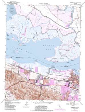
Honker Bay Topo Map California
To zoom in, hover over the map of Honker Bay
USGS Topo Quad 38121a8 - 1:24,000 scale
| Topo Map Name: | Honker Bay |
| USGS Topo Quad ID: | 38121a8 |
| Print Size: | ca. 21 1/4" wide x 27" high |
| Southeast Coordinates: | 38° N latitude / 121.875° W longitude |
| Map Center Coordinates: | 38.0625° N latitude / 121.9375° W longitude |
| U.S. State: | CA |
| Filename: | o38121a8.jpg |
| Download Map JPG Image: | Honker Bay topo map 1:24,000 scale |
| Map Type: | Topographic |
| Topo Series: | 7.5´ |
| Map Scale: | 1:24,000 |
| Source of Map Images: | United States Geological Survey (USGS) |
| Alternate Map Versions: |
Honker Bay CA 1953, updated 1955 Download PDF Buy paper map Honker Bay CA 1953, updated 1962 Download PDF Buy paper map Honker Bay CA 1953, updated 1969 Download PDF Buy paper map Honker Bay CA 1953, updated 1974 Download PDF Buy paper map Honker Bay CA 1953, updated 1981 Download PDF Buy paper map Honker Bay CA 1953, updated 1985 Download PDF Buy paper map Honker Bay CA 1953, updated 1985 Download PDF Buy paper map Honker Bay CA 2012 Download PDF Buy paper map Honker Bay CA 2015 Download PDF Buy paper map |
1:24,000 Topo Quads surrounding Honker Bay
> Back to 38121a1 at 1:100,000 scale
> Back to 38120a1 at 1:250,000 scale
> Back to U.S. Topo Maps home
Honker Bay topo map: Gazetteer
Honker Bay: Bays
Honker Bay elevation 0m 0′Suisun Bay elevation 0m 0′
Honker Bay: Canals
Contra Costa Canal elevation 37m 121′Honker Bay: Capes
Middle Point elevation 1m 3′New York Point elevation 0m 0′
Pelican Point elevation 1m 3′
Point Emmet elevation 0m 0′
Point Palo Alto elevation 0m 0′
Point Wall elevation 0m 0′
Point Wise elevation 1m 3′
Simmons Point elevation 1m 3′
Stake Point elevation 1m 3′
Honker Bay: Channels
East Reach elevation 0m 0′West Reach elevation 0m 0′
West Reach elevation 0m 0′
Honker Bay: Crossings
Exit 17 elevation 77m 252′Exit 19 elevation 50m 164′
Exit 20 elevation 38m 124′
Exit 23 elevation 19m 62′
Honker Bay: Guts
Champion Slough elevation 1m 3′Grizzly Slough elevation 1m 3′
Howard Slough elevation 1m 3′
Mallard Slough elevation 0m 0′
Mud Slough elevation 1m 3′
Norther Slough elevation 1m 3′
Noyce Slough elevation 1m 3′
Roaring River Slough elevation 1m 3′
Honker Bay: Islands
Chipps Island elevation 2m 6′Dutton Island elevation 1m 3′
Freeman Island elevation 1m 3′
Hammond Island elevation 1m 3′
Mallard Island elevation 1m 3′
Middle Ground Island elevation 1m 3′
Simmons Island elevation 1m 3′
Snag Island elevation 1m 3′
Van Sickle Island elevation 1m 3′
Wheeler Island elevation 1m 3′
Honker Bay: Parks
Ambrose Park elevation 33m 108′Ambrose Recreation Center elevation 20m 65′
Buchanan Park elevation 37m 121′
DeAnza Park elevation 13m 42′
Del Monte Recreation Center elevation 21m 68′
Marina Park elevation 2m 6′
Riverview Park elevation 2m 6′
Small World Park elevation 32m 104′
Stoneman Park elevation 59m 193′
Honker Bay: Populated Places
Ambrose (historical) elevation 5m 16′Chipps elevation 2m 6′
Cornwall elevation 12m 39′
Diamond elevation 13m 42′
Dutton elevation 1m 3′
McAvoy elevation 7m 22′
Nichols elevation 19m 62′
Pittsburg elevation 8m 26′
Shore Acres elevation 12m 39′
Spoonbill elevation 1m 3′
Honker Bay: Post Offices
Pittsburg Post Office elevation 8m 26′Honker Bay: Streams
Rack Creek elevation 1m 3′Spoonbill Creek elevation 0m 0′
Honker Bay: Valleys
Lawlor Ravine elevation 31m 101′Honker Bay digital topo map on disk
Buy this Honker Bay topo map showing relief, roads, GPS coordinates and other geographical features, as a high-resolution digital map file on DVD:


