Sacramento East Topo Map California
To zoom in, hover over the map of Sacramento East
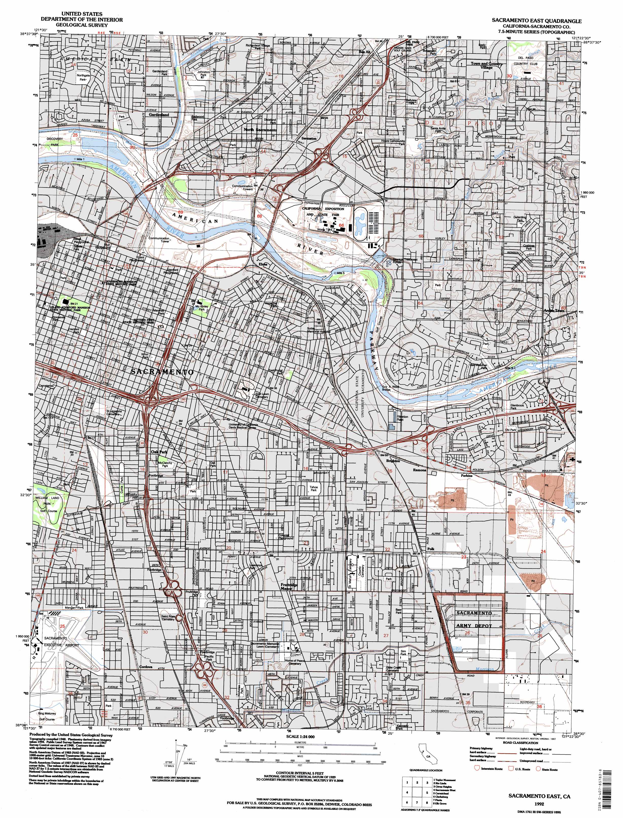
USGS Topo Quad 38121e4 - 1:24,000 scale
| Topo Map Name: | Sacramento East |
| USGS Topo Quad ID: | 38121e4 |
| Print Size: | ca. 21 1/4" wide x 27" high |
| Southeast Coordinates: | 38.5° N latitude / 121.375° W longitude |
| Map Center Coordinates: | 38.5625° N latitude / 121.4375° W longitude |
| U.S. State: | CA |
| Filename: | o38121e4.jpg |
| Download Map JPG Image: | Sacramento East topo map 1:24,000 scale |
| Map Type: | Topographic |
| Topo Series: | 7.5´ |
| Map Scale: | 1:24,000 |
| Source of Map Images: | United States Geological Survey (USGS) |
| Alternate Map Versions: |
Sacramento East CA 1949 Download PDF Buy paper map Sacramento East CA 1954, updated 1956 Download PDF Buy paper map Sacramento East CA 1954, updated 1964 Download PDF Buy paper map Sacramento East CA 1967, updated 1969 Download PDF Buy paper map Sacramento East CA 1967, updated 1977 Download PDF Buy paper map Sacramento East CA 1967, updated 1980 Download PDF Buy paper map Sacramento East CA 1992, updated 1997 Download PDF Buy paper map Sacramento East CA 2012 Download PDF Buy paper map Sacramento East CA 2015 Download PDF Buy paper map |
1:24,000 Topo Quads surrounding Sacramento East
Knights Landing |
Verona |
Pleasant Grove |
Roseville |
Rocklin |
Grays Bend |
Taylor Monument |
Rio Linda |
Citrus Heights |
Folsom |
Davis |
Sacramento West |
Sacramento East |
Carmichael |
Buffalo Creek |
Saxon |
Clarksburg |
Florin |
Elk Grove |
Sloughhouse |
Liberty Island |
Courtland |
Bruceville |
Galt |
Clay |
> Back to 38121e1 at 1:100,000 scale
> Back to 38120a1 at 1:250,000 scale
> Back to U.S. Topo Maps home
Sacramento East topo map: Gazetteer
Sacramento East: Airports
Lake Park Helistop elevation 13m 42′Sacramento Executive Airport elevation 6m 19′
UCDMC Heliport elevation 10m 32′
Sacramento East: Bridges
Guy A West Bridge elevation 7m 22′Sacramento East: Crossings
Exit 10A elevation 13m 42′Exit 10B elevation 14m 45′
Exit 11 elevation 14m 45′
Exit 11 elevation 16m 52′
Exit 294A elevation 9m 29′
Exit 294B elevation 9m 29′
Exit 295 elevation 8m 26′
Exit 296 elevation 13m 42′
Exit 297 elevation 7m 22′
Exit 298A elevation 8m 26′
Exit 298B elevation 11m 36′
Exit 46A elevation 12m 39′
Exit 46B elevation 10m 32′
Exit 47A elevation 12m 39′
Exit 47B elevation 9m 29′
Exit 48 elevation 16m 52′
Exit 5 elevation 12m 39′
Exit 6A elevation 11m 36′
Exit 6B elevation 8m 26′
Exit 6C elevation 13m 42′
Exit 7 elevation 10m 32′
Exit 7A elevation 8m 26′
Exit 7B elevation 11m 36′
Exit 8A elevation 10m 32′
Exit 8B elevation 12m 39′
Exit 9 elevation 12m 39′
Exit 9A elevation 12m 39′
Exit 9B elevation 11m 36′
Sacramento East: Lakes
Bushy Lake (historical) elevation 10m 32′Corral Lake (historical) elevation 12m 39′
Deadmans Lake (historical) elevation 8m 26′
Sacramento East: Parks
Airport Park elevation 8m 26′Alkali Flat Central Historic District elevation 9m 29′
Alkali Flat North Historic District elevation 10m 32′
Alkali Flat West Historic District elevation 10m 32′
Alkali Playground elevation 11m 36′
American Lakes School Park elevation 5m 16′
Applequist Athletic Field elevation 8m 26′
Babcock Park elevation 11m 36′
Baer Park elevation 11m 36′
Bellview Park elevation 16m 52′
Ben Ali School Park elevation 15m 49′
Bohemian Park elevation 16m 52′
Bowling Green Park elevation 7m 22′
Brockway Park elevation 7m 22′
Brockway Park elevation 7m 22′
California School Park elevation 5m 16′
California Vietnam Veterans Memorial elevation 7m 22′
California Vietnam Veterans Memorial elevation 7m 22′
Camellia Park elevation 10m 32′
Capitol Park elevation 7m 22′
Coloma Park elevation 10m 32′
Colonial Playground elevation 11m 36′
Cottage Park elevation 15m 49′
Crabtree Park elevation 19m 62′
Creekside Oaks Park elevation 5m 16′
Creekside Park elevation 18m 59′
Curtis Park elevation 7m 22′
Da Vinci School Park elevation 7m 22′
Deterding Park elevation 18m 59′
Discovery Park elevation 7m 22′
Dixieland Park elevation 13m 42′
Dos Rios School Park elevation 9m 29′
Earl Warren Park elevation 11m 36′
East Lawn Childrens Park elevation 8m 26′
East Portal Park elevation 10m 32′
Florin Reservoir Park elevation 10m 32′
Fountain Park Plaza elevation 8m 26′
Fremont Park elevation 6m 19′
Fruitridge Park elevation 9m 29′
Gardenland Park elevation 7m 22′
Glenbrook Park elevation 13m 42′
Governor's Mansion State Historic Park elevation 7m 22′
Granite Park elevation 6m 19′
Grant Playground elevation 12m 39′
Greenfair Park elevation 11m 36′
Hagginwood School Park elevation 12m 39′
Hall Park elevation 11m 36′
Hall Park elevation 10m 32′
Henschel Park elevation 10m 32′
Hoos Swimming Pool elevation 8m 26′
Hornet Stadium elevation 12m 39′
Howe Community Park elevation 15m 49′
Hughes Stadium elevation 9m 29′
Jack Davis Park elevation 10m 32′
Jefferson School Park elevation 12m 39′
Johnston Park elevation 8m 26′
Jonas Larkspur Park elevation 16m 52′
Kennedy Park elevation 10m 32′
Lawrence Playground elevation 10m 32′
Leland Stanford Mansion State Historic Park elevation 6m 19′
Little League Park elevation 13m 42′
Lubin School Park elevation 9m 29′
Mangan Park elevation 7m 22′
Maple School Park elevation 8m 26′
Marshall Park elevation 9m 29′
McClatchy Park elevation 9m 29′
McClatchy School Park elevation 5m 16′
McKinley Park elevation 8m 26′
Muir Playground elevation 11m 36′
Neely Johnson Park elevation 9m 29′
Nicholas Park elevation 7m 22′
Ninos Park elevation 7m 22′
North del Rio School Park elevation 8m 26′
Northgate Park elevation 5m 16′
Oak Meadow Park elevation 13m 42′
Oak Park elevation 8m 26′
Oak Park elevation 8m 26′
Oki Park elevation 13m 42′
Orville Wright Park elevation 21m 68′
P Z Cervantes Park elevation 7m 22′
Pacific Park elevation 10m 32′
Phillips School Park elevation 10m 32′
Plaza Park elevation 9m 29′
Rainbow Mini Park elevation 8m 26′
Redwood Park elevation 8m 26′
Richardson Village Park elevation 9m 29′
River Park elevation 12m 39′
Riverfront Park elevation 11m 36′
Roosevelt Park elevation 6m 19′
Sacramento School Park elevation 9m 29′
Santa Anita Park elevation 13m 42′
Seely Park elevation 20m 65′
Seventeenth Avenue Park elevation 12m 39′
Sierra School Park elevation 7m 22′
Sierra Vista Park elevation 10m 32′
Sim Park elevation 11m 36′
Stanford Playground elevation 12m 39′
Strauch School Park elevation 5m 16′
Sunset Park elevation 8m 26′
Sutter's Fort State Historic Park elevation 8m 26′
Swanston Park elevation 11m 36′
Tahoe Park elevation 11m 36′
Temple Avenue Park elevation 9m 29′
Triangle Park elevation 10m 32′
Twain School Park elevation 10m 32′
Twenty-First Avenue Parkway elevation 11m 36′
Union Stadium elevation 8m 26′
Washington Park elevation 9m 29′
Waterworld USA elevation 11m 36′
Wells Fargo Pavilion elevation 7m 22′
William Land Park elevation 7m 22′
Winn Park elevation 8m 26′
Winterstein Park elevation 17m 55′
Wood School Park elevation 10m 32′
Woodbine Park elevation 6m 19′
Woodbine School Park elevation 6m 19′
Woodlake Park elevation 9m 29′
Zapata Park elevation 10m 32′
Sacramento East: Populated Places
Arcade elevation 20m 65′Arden Town elevation 18m 59′
Ben Ali elevation 16m 52′
Brighton elevation 14m 45′
Cordova elevation 7m 22′
Elvas elevation 13m 42′
Fruitridge Manor elevation 10m 32′
Gardenland elevation 7m 22′
Highland Park elevation 6m 19′
North Sacramento elevation 10m 32′
Oak Park elevation 9m 29′
Perkins elevation 15m 49′
Polk elevation 13m 42′
Ramona elevation 14m 45′
Sacramento elevation 9m 29′
South Sacramento elevation 8m 26′
Swanston elevation 13m 42′
Town and Country Village elevation 20m 65′
Sacramento East: Post Offices
Arden Post Office elevation 16m 52′Broadway Post Office elevation 8m 26′
Camellia Post Office elevation 11m 36′
Colonial Post Office elevation 9m 29′
Country Club Centre Post Office elevation 19m 62′
Fort Sutter Post Office elevation 9m 29′
Metro Post Office elevation 8m 26′
Oak Park Post Office elevation 9m 29′
Sacramento Main Post Office elevation 9m 29′
Town and Country Post Office elevation 19m 62′
Sacramento East: Streams
Arcade Creek elevation 6m 19′Chicken Ranch Slough elevation 9m 29′
Strong Ranch Slough elevation 10m 32′
Sacramento East: Summits
Whisky Hill elevation 10m 32′Sacramento East: Woods
Alumni Grove elevation 9m 29′Sacramento East digital topo map on disk
Buy this Sacramento East topo map showing relief, roads, GPS coordinates and other geographical features, as a high-resolution digital map file on DVD: