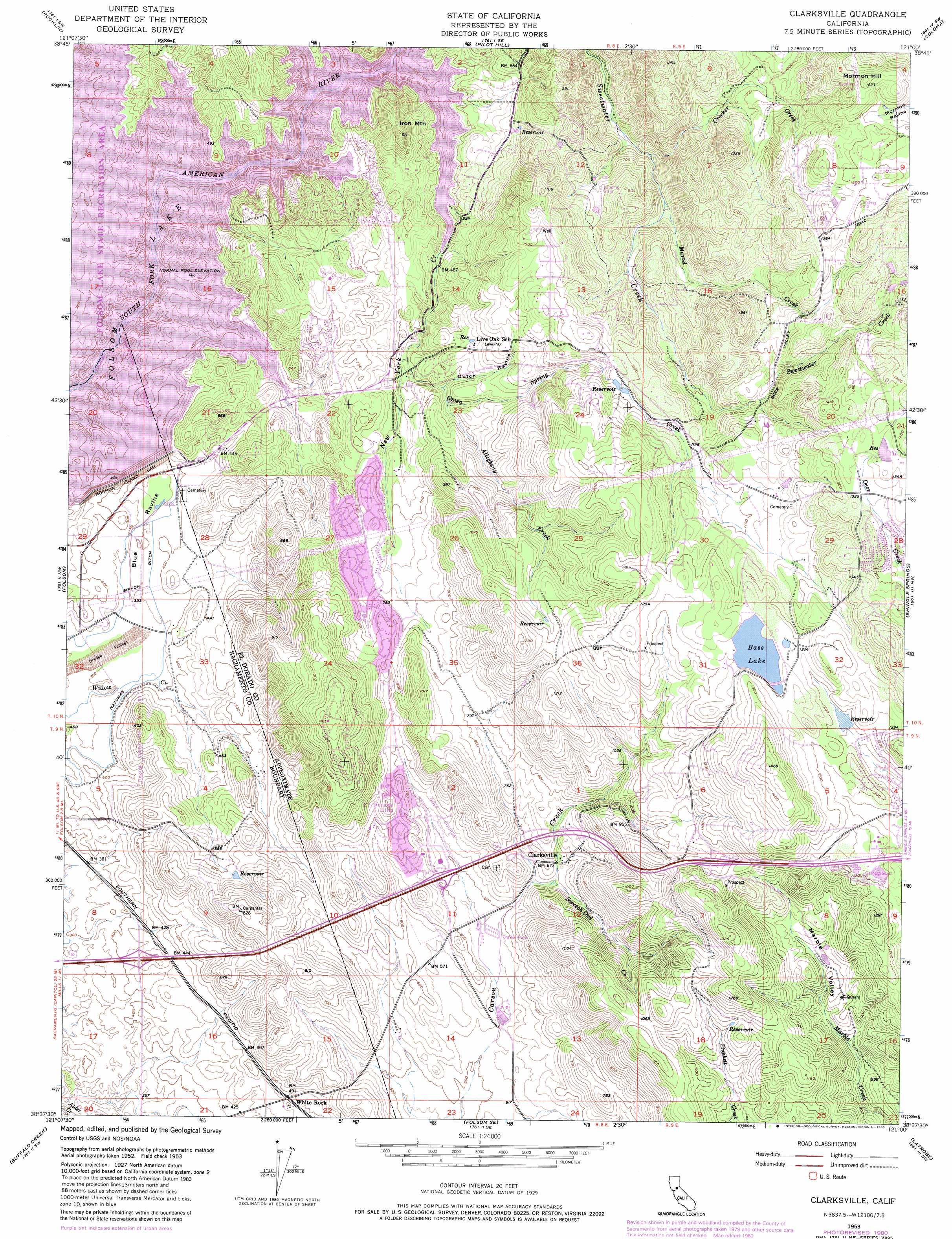
Clarksville Topo Map California
To zoom in, hover over the map of Clarksville
USGS Topo Quad 38121f1 - 1:24,000 scale
| Topo Map Name: | Clarksville |
| USGS Topo Quad ID: | 38121f1 |
| Print Size: | ca. 21 1/4" wide x 27" high |
| Southeast Coordinates: | 38.625° N latitude / 121° W longitude |
| Map Center Coordinates: | 38.6875° N latitude / 121.0625° W longitude |
| U.S. State: | CA |
| Filename: | o38121f1.jpg |
| Download Map JPG Image: | Clarksville topo map 1:24,000 scale |
| Map Type: | Topographic |
| Topo Series: | 7.5´ |
| Map Scale: | 1:24,000 |
| Source of Map Images: | United States Geological Survey (USGS) |
| Alternate Map Versions: |
Clarksville CA 1953, updated 1955 Download PDF Buy paper map Clarksville CA 1953, updated 1960 Download PDF Buy paper map Clarksville CA 1953, updated 1972 Download PDF Buy paper map Clarksville CA 1953, updated 1976 Download PDF Buy paper map Clarksville CA 1953, updated 1976 Download PDF Buy paper map Clarksville CA 1953, updated 1980 Download PDF Buy paper map Clarksville CA 1953, updated 1980 Download PDF Buy paper map Clarksville CA 2012 Download PDF Buy paper map Clarksville CA 2015 Download PDF Buy paper map |
1:24,000 Topo Quads surrounding Clarksville
Lincoln |
Gold Hill |
Auburn |
Greenwood |
Georgetown |
Roseville |
Rocklin |
Pilot Hill |
Coloma |
Garden Valley |
Citrus Heights |
Folsom |
Clarksville |
Shingle Springs |
Placerville |
Carmichael |
Buffalo Creek |
Folsom Se |
Latrobe |
Fiddletown |
Elk Grove |
Sloughhouse |
Carbondale |
Irish Hill |
Amador City |
> Back to 38121e1 at 1:100,000 scale
> Back to 38120a1 at 1:250,000 scale
> Back to U.S. Topo Maps home
Clarksville topo map: Gazetteer
Clarksville: Bays
Browns Ravine Cove elevation 143m 469′Deep Ravine Cove elevation 143m 469′
First Cove elevation 143m 469′
Lake Hill Cove elevation 143m 469′
New York Creek Cove elevation 143m 469′
Clarksville: Canals
Natomas Ditch elevation 116m 380′Clarksville: Capes
Bridge Point elevation 162m 531′Cattlemans Point elevation 150m 492′
Knoxton Point elevation 149m 488′
Peanut Point elevation 144m 472′
Peter Point elevation 153m 501′
Clarksville: Crossings
Exit 27 elevation 135m 442′Exit 30 elevation 191m 626′
Exit 32 elevation 318m 1043′
Clarksville: Dams
El Dorado Hills 53-008 Dam elevation 170m 557′Folsom Saddle Dam elevation 143m 469′
Mormon Island Dam elevation 150m 492′
New Bass Lake 53-007 Dam elevation 358m 1174′
Clarksville: Mines
Mormon Hill Mine elevation 440m 1443′Clarksville: Parks
Art Weisburg Park elevation 203m 666′Briggs Ranch Neighborhood Park elevation 128m 419′
Browns Ravine Recreation Area elevation 143m 469′
Crescent Ridge Park elevation 202m 662′
El Dorado Hills Archery Range elevation 218m 715′
El Dorado Hills Community Park elevation 228m 748′
Mormon Island Wetlands State Park elevation 115m 377′
Pleasant Grove House State Historic Landmark elevation 344m 1128′
Pony Express Station Historic Site elevation 210m 688′
Prewitt Park elevation 116m 380′
Ridgeview Park elevation 348m 1141′
Saint Andrews Park elevation 209m 685′
Sweetwater Basin Wildlife Area elevation 146m 479′
Willow Creek Mini Park elevation 114m 374′
Clarksville: Populated Places
Arroyo Vista elevation 297m 974′Bar J Ranch elevation 364m 1194′
Briarwood Canyon elevation 378m 1240′
Cambridge Oaks elevation 353m 1158′
Clarksville elevation 206m 675′
Crescent Ridge Village elevation 216m 708′
Crown Village elevation 227m 744′
El Dorado Hills elevation 234m 767′
Equestrian Village elevation 197m 646′
Franciscan Village elevation 220m 721′
Governors Village elevation 229m 751′
Green Springs Ranch elevation 317m 1040′
Green Springs Valley elevation 331m 1085′
Green Valley Acres elevation 207m 679′
Hickok Ranch elevation 301m 987′
Hidden Valley elevation 157m 515′
Highland Village elevation 228m 748′
La Cresta Village elevation 284m 931′
Lake Hills Estates elevation 149m 488′
Lakeridge Oaks elevation 145m 475′
Manzanita Acres elevation 248m 813′
Marble Mountain elevation 344m 1128′
Marina Village elevation 211m 692′
Oak Creek Hills elevation 180m 590′
Oak Ridge Village elevation 245m 803′
Oak Tree Village elevation 197m 646′
Park Village elevation 216m 708′
Ridgeview Village elevation 325m 1066′
Saint Andrews Village elevation 227m 744′
Springfield Meadows elevation 176m 577′
Stonegate Village elevation 227m 744′
Summit Village elevation 193m 633′
Sunset Mobile Home Park elevation 177m 580′
Waterford Village elevation 204m 669′
White Rock elevation 150m 492′
Winterhaven Village elevation 203m 666′
Clarksville: Post Offices
El Dorado Hills Post Office elevation 190m 623′Clarksville: Reservoirs
Bass Lake elevation 358m 1174′Carson Creek Watershed Reservoir elevation 170m 557′
Clarksville: Streams
Allegheny Creek elevation 198m 649′Crocker Creek elevation 185m 606′
Green Spring Creek elevation 177m 580′
Martel Creek elevation 213m 698′
New York Creek elevation 143m 469′
Screech Owl Creek elevation 193m 633′
Clarksville: Summits
Iron Mountain elevation 269m 882′Mormon Hill elevation 462m 1515′
Clarksville: Trails
South Shore Riding and Hiking Trail elevation 154m 505′Clarksville: Valleys
Blue Ravine elevation 116m 380′Deep Ravine elevation 143m 469′
Dutch Ravine elevation 193m 633′
Marble Valley elevation 252m 826′
Clarksville digital topo map on disk
Buy this Clarksville topo map showing relief, roads, GPS coordinates and other geographical features, as a high-resolution digital map file on DVD: