Citrus Heights Topo Map California
To zoom in, hover over the map of Citrus Heights
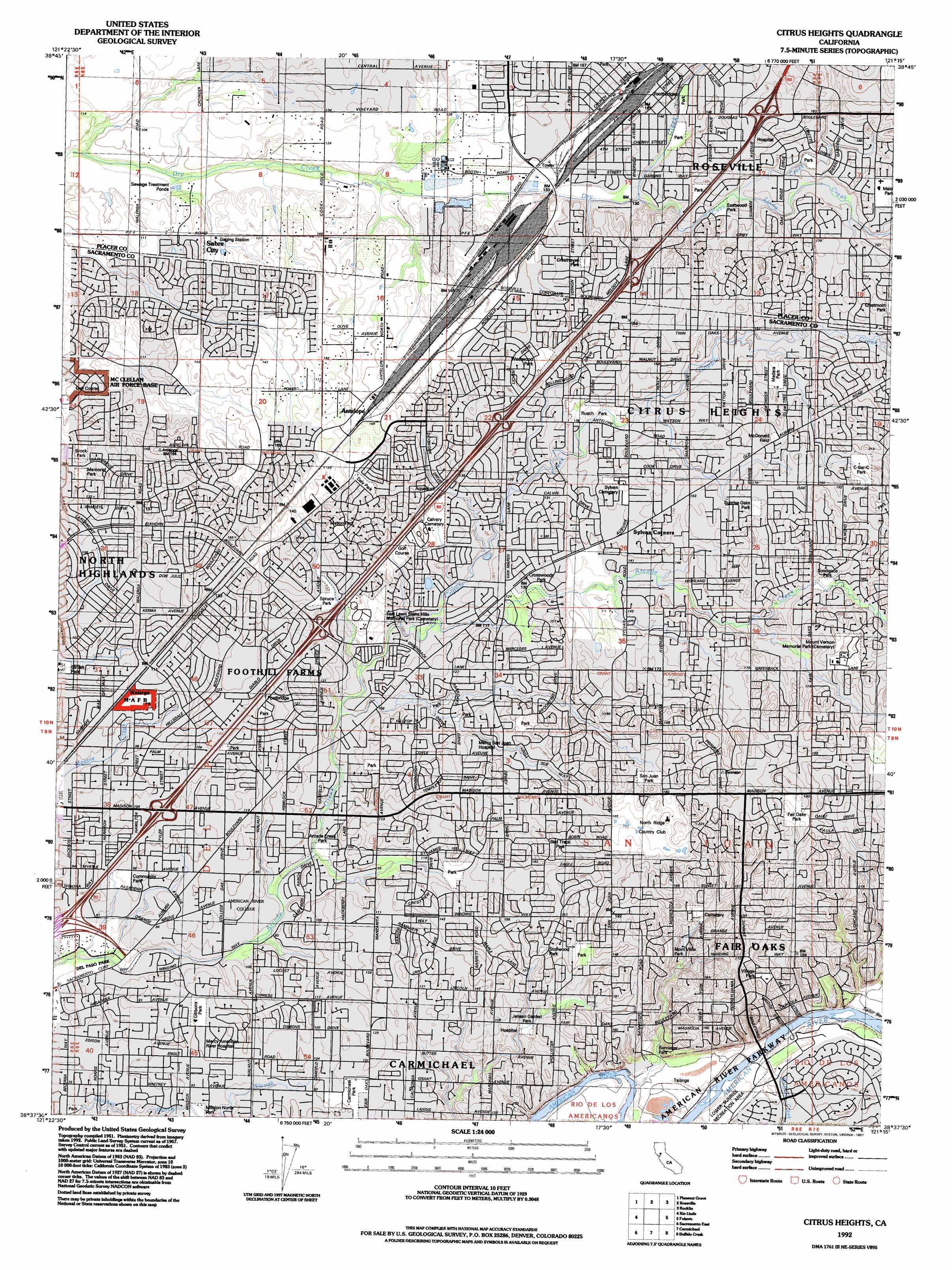
USGS Topo Quad 38121f3 - 1:24,000 scale
| Topo Map Name: | Citrus Heights |
| USGS Topo Quad ID: | 38121f3 |
| Print Size: | ca. 21 1/4" wide x 27" high |
| Southeast Coordinates: | 38.625° N latitude / 121.25° W longitude |
| Map Center Coordinates: | 38.6875° N latitude / 121.3125° W longitude |
| U.S. State: | CA |
| Filename: | o38121f3.jpg |
| Download Map JPG Image: | Citrus Heights topo map 1:24,000 scale |
| Map Type: | Topographic |
| Topo Series: | 7.5´ |
| Map Scale: | 1:24,000 |
| Source of Map Images: | United States Geological Survey (USGS) |
| Alternate Map Versions: |
Citrus Heights CA 1951, updated 1952 Download PDF Buy paper map Citrus Heights CA 1951, updated 1956 Download PDF Buy paper map Citrus Heights CA 1951, updated 1956 Download PDF Buy paper map Citrus Heights CA 1967, updated 1969 Download PDF Buy paper map Citrus Heights CA 1967, updated 1969 Download PDF Buy paper map Citrus Heights CA 1967, updated 1977 Download PDF Buy paper map Citrus Heights CA 1967, updated 1977 Download PDF Buy paper map Citrus Heights CA 1967, updated 1980 Download PDF Buy paper map Citrus Heights CA 1967, updated 1984 Download PDF Buy paper map Citrus Heights CA 1975, updated 1977 Download PDF Buy paper map Citrus Heights CA 1975, updated 1978 Download PDF Buy paper map Citrus Heights CA 1992, updated 1997 Download PDF Buy paper map Citrus Heights CA 2012 Download PDF Buy paper map Citrus Heights CA 2015 Download PDF Buy paper map |
1:24,000 Topo Quads surrounding Citrus Heights
Nicolaus |
Sheridan |
Lincoln |
Gold Hill |
Auburn |
Verona |
Pleasant Grove |
Roseville |
Rocklin |
Pilot Hill |
Taylor Monument |
Rio Linda |
Citrus Heights |
Folsom |
Clarksville |
Sacramento West |
Sacramento East |
Carmichael |
Buffalo Creek |
Folsom Se |
Clarksburg |
Florin |
Elk Grove |
Sloughhouse |
Carbondale |
> Back to 38121e1 at 1:100,000 scale
> Back to 38120a1 at 1:250,000 scale
> Back to U.S. Topo Maps home
Citrus Heights topo map: Gazetteer
Citrus Heights: Airports
Pruett Airport elevation 46m 150′Citrus Heights: Bars
Rossmoor Bar elevation 22m 72′Sacramento Bar elevation 22m 72′
Citrus Heights: Crossings
Exit 100 elevation 46m 150′Exit 102 elevation 50m 164′
Exit 103 elevation 53m 173′
Exit 96 elevation 34m 111′
Exit 98 elevation 43m 141′
Citrus Heights: Parks
Antelope Community Park elevation 45m 147′Arcade Creek Nature Area elevation 26m 85′
Arcade Creek Park elevation 29m 95′
Bannister Park elevation 36m 118′
Bird Track Park elevation 55m 180′
Brock Park elevation 36m 118′
Brooktree Park elevation 46m 150′
Carmichael Park elevation 33m 108′
C-Bar-C Park elevation 61m 200′
Chardonay Park elevation 49m 160′
Cherry Creek Park elevation 43m 141′
Churchill Park elevation 29m 95′
Cirby Creek Park elevation 39m 127′
Community Park elevation 28m 91′
Cresthaven Park elevation 52m 170′
Crestmont Park elevation 64m 209′
Crosswoods Park elevation 37m 121′
Daly Park elevation 48m 157′
Del Campo Park elevation 37m 121′
Eastwood Park elevation 43m 141′
Fair Oaks Park elevation 65m 213′
Garbolino Park elevation 51m 167′
Gibbons Park elevation 32m 104′
Greenback Park elevation 43m 141′
Jensen Garden Park elevation 32m 104′
Kenwood Oaks Park elevation 56m 183′
Kohler Park elevation 31m 101′
Madera Park elevation 53m 173′
Manzanita Park elevation 37m 121′
Mark White Park elevation 42m 137′
Mason Park elevation 43m 141′
McDonald Field elevation 59m 193′
Memorial Park elevation 38m 124′
Mission North Park elevation 26m 85′
Mont View Park elevation 47m 154′
Northwoods Park elevation 65m 213′
Park Oaks elevation 36m 118′
Pioneer Park elevation 38m 124′
Pioneer Park elevation 46m 150′
Pokelma Park elevation 36m 118′
Royer Park elevation 42m 137′
Rusch Park elevation 41m 134′
Rushmore Jeanine Park elevation 41m 134′
San Juan Park elevation 56m 183′
Saugstad Park elevation 42m 137′
Shadowcreek Park elevation 34m 111′
Sierra Gardens Park elevation 45m 147′
Spruce Park elevation 37m 121′
Stollwood Park elevation 43m 141′
Strizek Park elevation 28m 91′
Sundance Park elevation 53m 173′
Sunrise Oaks Park elevation 53m 173′
Tempo Park elevation 48m 157′
Tetotom Park elevation 43m 141′
Village Park elevation 60m 196′
Walerga Park elevation 40m 131′
Westwood Park elevation 43m 141′
Citrus Heights: Populated Places
Antelope elevation 50m 164′Citrus Heights elevation 50m 164′
Fair Oaks elevation 53m 173′
Fairoaks Bridge (historical) elevation 31m 101′
Foothill Farms elevation 43m 141′
North Highlands elevation 28m 91′
Sabre City elevation 42m 137′
Walerga elevation 34m 111′
Citrus Heights: Post Offices
Carmichael Post Office elevation 33m 108′Citrus Heights Post Office elevation 53m 173′
Fair Oaks Post Office elevation 46m 150′
Foothill Farms Post Office elevation 33m 108′
Roseville Post Office elevation 47m 154′
Citrus Heights: Streams
Buffalo Creek elevation 29m 95′Cirby Creek elevation 42m 137′
Cripple Creek elevation 31m 101′
Linda Creek elevation 43m 141′
Citrus Heights: Valleys
Strap Ravine elevation 45m 147′Citrus Heights digital topo map on disk
Buy this Citrus Heights topo map showing relief, roads, GPS coordinates and other geographical features, as a high-resolution digital map file on DVD: