Rocklin Topo Map California
To zoom in, hover over the map of Rocklin
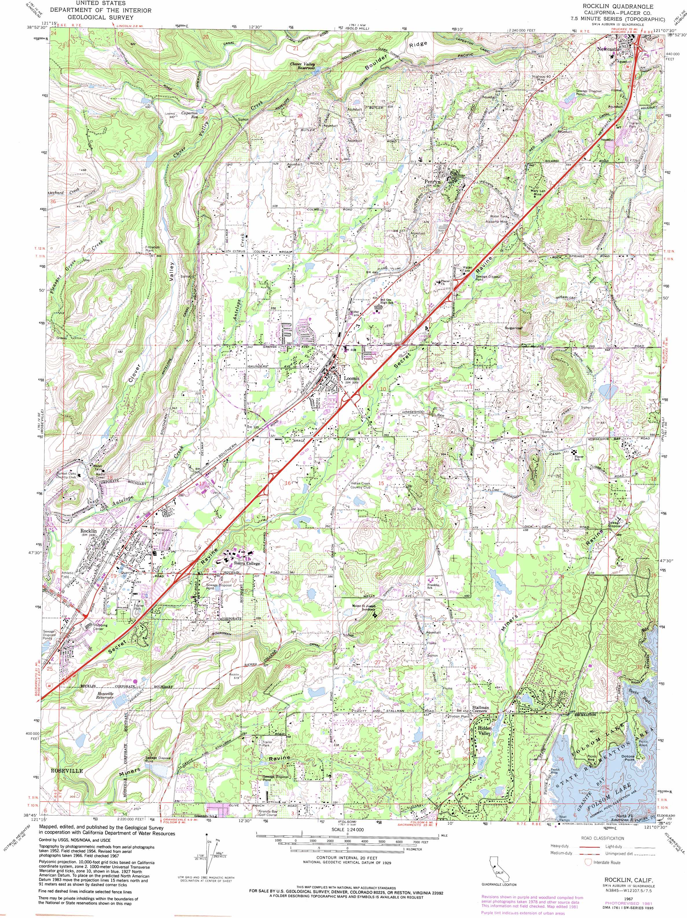
USGS Topo Quad 38121g2 - 1:24,000 scale
| Topo Map Name: | Rocklin |
| USGS Topo Quad ID: | 38121g2 |
| Print Size: | ca. 21 1/4" wide x 27" high |
| Southeast Coordinates: | 38.75° N latitude / 121.125° W longitude |
| Map Center Coordinates: | 38.8125° N latitude / 121.1875° W longitude |
| U.S. State: | CA |
| Filename: | o38121g2.jpg |
| Download Map JPG Image: | Rocklin topo map 1:24,000 scale |
| Map Type: | Topographic |
| Topo Series: | 7.5´ |
| Map Scale: | 1:24,000 |
| Source of Map Images: | United States Geological Survey (USGS) |
| Alternate Map Versions: |
Rocklin CA 1954, updated 1955 Download PDF Buy paper map Rocklin CA 1954, updated 1961 Download PDF Buy paper map Rocklin CA 1967, updated 1968 Download PDF Buy paper map Rocklin CA 1967, updated 1981 Download PDF Buy paper map Rocklin CA 1967, updated 1981 Download PDF Buy paper map Rocklin CA 2012 Download PDF Buy paper map Rocklin CA 2015 Download PDF Buy paper map |
1:24,000 Topo Quads surrounding Rocklin
Wheatland |
Camp Far West |
Wolf |
Lake Combie |
Colfax |
Sheridan |
Lincoln |
Gold Hill |
Auburn |
Greenwood |
Pleasant Grove |
Roseville |
Rocklin |
Pilot Hill |
Coloma |
Rio Linda |
Citrus Heights |
Folsom |
Clarksville |
Shingle Springs |
Sacramento East |
Carmichael |
Buffalo Creek |
Folsom Se |
Latrobe |
> Back to 38121e1 at 1:100,000 scale
> Back to 38120a1 at 1:250,000 scale
> Back to U.S. Topo Maps home
Rocklin topo map: Gazetteer
Rocklin: Airports
Holsclaws Stol Strip Stolport elevation 123m 403′Rocklin: Bays
Beeks Bight elevation 143m 469′Granite Bay elevation 143m 469′
Rocklin: Canals
Antelope Canal elevation 240m 787′Barton Canal elevation 195m 639′
Baughman Canal elevation 145m 475′
Ben Franklin Canal elevation 190m 623′
Morgan Canal elevation 188m 616′
Penryn Canal elevation 230m 754′
Perry Canal elevation 192m 629′
Red Ravine Canal elevation 183m 600′
Sugarloaf Canal elevation 209m 685′
Turner Canal elevation 156m 511′
Rocklin: Capes
Dotons Point elevation 150m 492′Rocklin: Crossings
Exit 108 elevation 86m 282′Exit 109 elevation 106m 347′
Exit 110 elevation 116m 380′
Exit 112 elevation 134m 439′
Exit 115 elevation 275m 902′
Rocklin: Dams
Clover Valley 1030-005 Dam elevation 198m 649′Folsom Dikes 1,2 and 3 Dam elevation 143m 469′
Kokila 320 Dam elevation 120m 393′
Mammoth Reservoir 1030-006 Dam elevation 197m 646′
Rocklin: Mines
Alabama Mine elevation 173m 567′Highway Forty Mine elevation 219m 718′
Mary Len Mine elevation 165m 541′
Sicily Mine elevation 231m 757′
Rocklin: Parks
Clover Valley Park elevation 79m 259′Griffith Quarry Historic Park elevation 218m 715′
Johnson-Springview Park elevation 69m 226′
Loomis Basin Regional Park elevation 115m 377′
Old Timers Park elevation 76m 249′
Quarry Park elevation 81m 265′
Sierra Meadows Park elevation 86m 282′
Woodside Park elevation 69m 226′
Rocklin: Populated Places
Granite Bay elevation 130m 426′Hidden Valley elevation 133m 436′
Loomis elevation 123m 403′
Newcastle elevation 288m 944′
Penryn elevation 191m 626′
Rocklin elevation 79m 259′
Rocklin: Post Offices
Loomis Post Office elevation 121m 396′Newcastle Post Office elevation 281m 921′
Penryn Post Office elevation 193m 633′
Rocklin Post Office elevation 74m 242′
Rocklin: Reservoirs
Caperton Reservoir elevation 190m 623′Clover Valley Reservoir elevation 198m 649′
Roseville Reservoir elevation 102m 334′
Rocklin: Ridges
Boulder Ridge elevation 271m 889′Rocklin: Streams
Clover Valley Creek elevation 71m 232′Rocklin: Summits
Sugarloaf elevation 218m 715′Rocklin: Tunnels
Clark Tunnel elevation 262m 859′Rocklin: Valleys
Clover Valley elevation 70m 229′Rocklin digital topo map on disk
Buy this Rocklin topo map showing relief, roads, GPS coordinates and other geographical features, as a high-resolution digital map file on DVD: