Lake Berryessa Topo Map California
To zoom in, hover over the map of Lake Berryessa
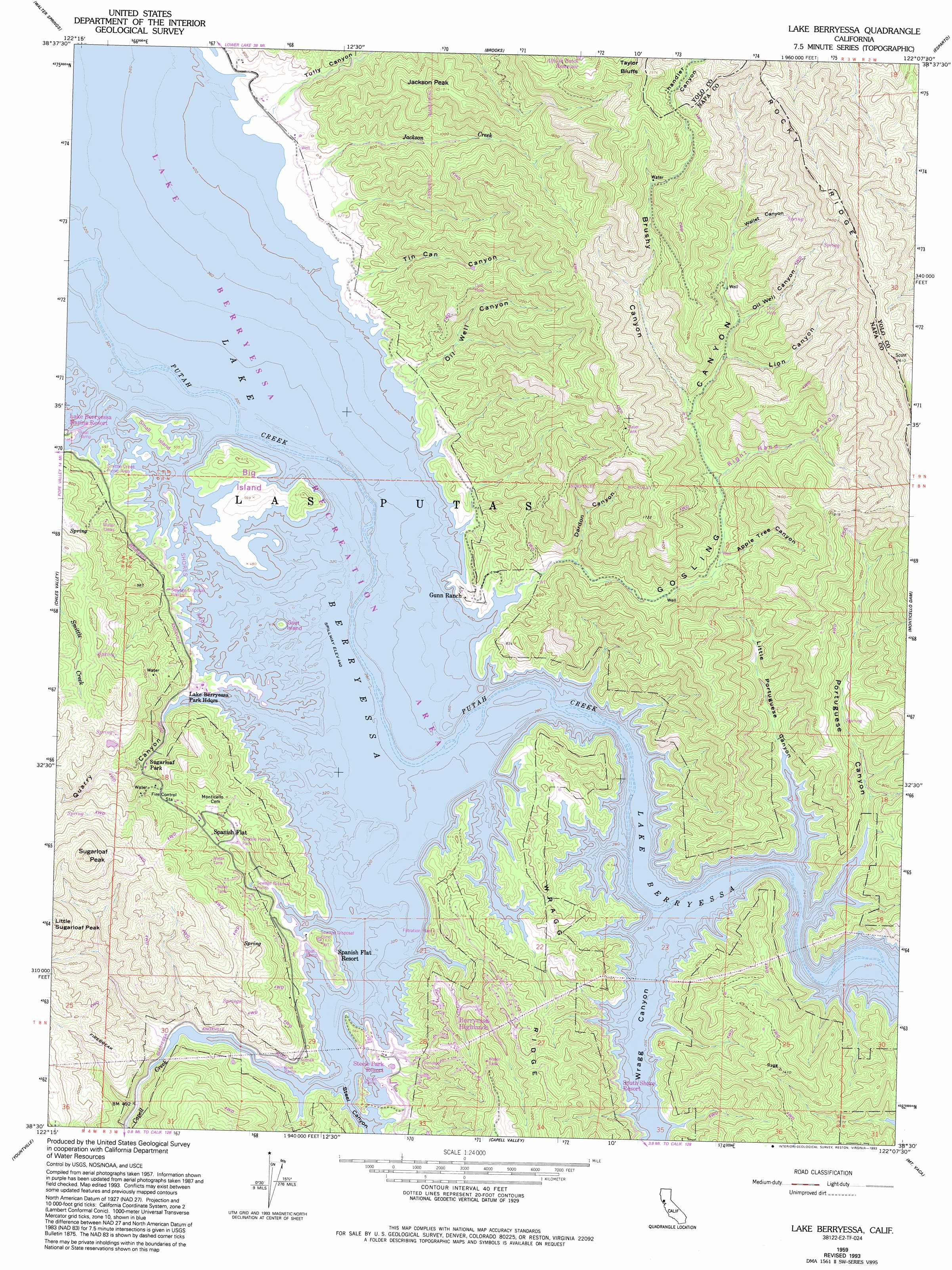
USGS Topo Quad 38122e2 - 1:24,000 scale
| Topo Map Name: | Lake Berryessa |
| USGS Topo Quad ID: | 38122e2 |
| Print Size: | ca. 21 1/4" wide x 27" high |
| Southeast Coordinates: | 38.5° N latitude / 122.125° W longitude |
| Map Center Coordinates: | 38.5625° N latitude / 122.1875° W longitude |
| U.S. State: | CA |
| Filename: | o38122e2.jpg |
| Download Map JPG Image: | Lake Berryessa topo map 1:24,000 scale |
| Map Type: | Topographic |
| Topo Series: | 7.5´ |
| Map Scale: | 1:24,000 |
| Source of Map Images: | United States Geological Survey (USGS) |
| Alternate Map Versions: |
Lake Berryessa CA 1959, updated 1961 Download PDF Buy paper map Lake Berryessa CA 1959, updated 1970 Download PDF Buy paper map Lake Berryessa CA 1959, updated 1980 Download PDF Buy paper map Lake Berryessa CA 1959, updated 1993 Download PDF Buy paper map Lake Berryessa CA 1998, updated 2002 Download PDF Buy paper map Lake Berryessa CA 2012 Download PDF Buy paper map Lake Berryessa CA 2015 Download PDF Buy paper map |
1:24,000 Topo Quads surrounding Lake Berryessa
Jericho Valley |
Knoxville |
Guinda |
Bird Valley |
Zamora |
Aetna Springs |
Walter Springs |
Brooks |
Esparto |
Madison |
Saint Helena |
Chiles Valley |
Lake Berryessa |
Monticello Dam |
Winters |
Rutherford |
Yountville |
Capell Valley |
Mount Vaca |
Allendale |
Sonoma |
Napa |
Mount George |
Fairfield North |
Elmira |
> Back to 38122e1 at 1:100,000 scale
> Back to 38122a1 at 1:250,000 scale
> Back to U.S. Topo Maps home
Lake Berryessa topo map: Gazetteer
Lake Berryessa: Islands
Big Island elevation 135m 442′Goat Island elevation 135m 442′
Small Island elevation 135m 442′
Lake Berryessa: Parks
Lake Berryessa Recreation Area elevation 135m 442′Lake Berryessa: Populated Places
Berryessa Highlands elevation 196m 643′Monticello (historical) elevation 135m 442′
Redbud Park (historical) elevation 135m 442′
Spanish Flat elevation 173m 567′
Spanish Flat Resort elevation 152m 498′
Steel Canyon Resort elevation 135m 442′
Lake Berryessa: Ridges
Rocky Ridge elevation 694m 2276′Lake Berryessa: Streams
Jackson Creek elevation 158m 518′Lake Berryessa: Summits
Jackson Peak elevation 552m 1811′Sugarloaf Peak elevation 568m 1863′
Lake Berryessa: Valleys
Apple Tree Canyon elevation 219m 718′Brushy Canyon elevation 269m 882′
Dardon Canyon elevation 156m 511′
Gosling Canyon elevation 135m 442′
Lion Canyon elevation 312m 1023′
Little Portuguese Canyon elevation 135m 442′
Oil Well Canyon elevation 336m 1102′
Oil Well Canyon elevation 143m 469′
Portuguese Canyon elevation 135m 442′
Quarry Canyon elevation 135m 442′
Right-Hand Canyon elevation 243m 797′
Steel Canyon elevation 135m 442′
Tin Can Canyon elevation 147m 482′
Tully Canyon elevation 156m 511′
Wallet Canyon elevation 407m 1335′
Wragg Canyon elevation 135m 442′
Lake Berryessa digital topo map on disk
Buy this Lake Berryessa topo map showing relief, roads, GPS coordinates and other geographical features, as a high-resolution digital map file on DVD: