Annapolis Topo Map California
To zoom in, hover over the map of Annapolis
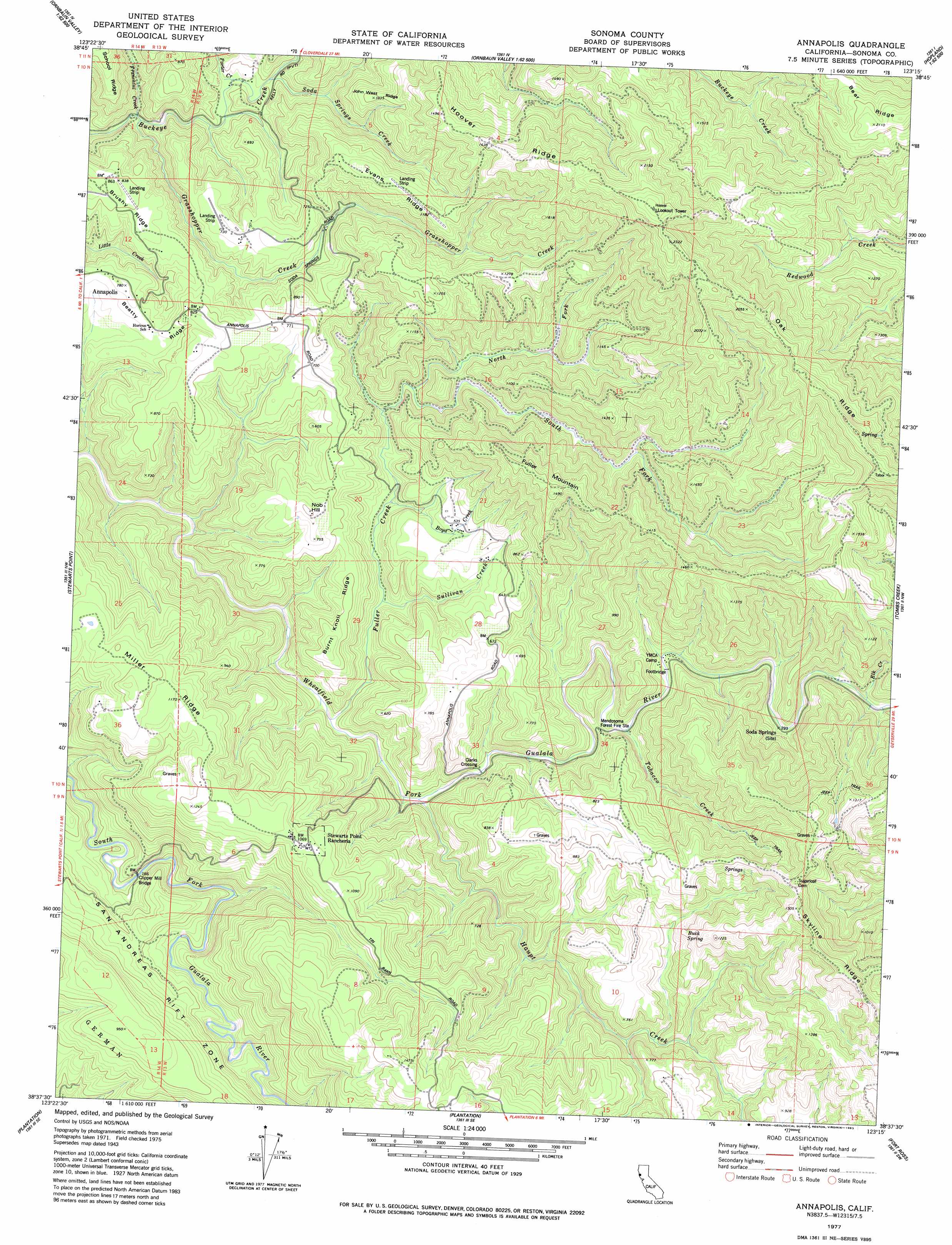
USGS Topo Quad 38123f3 - 1:24,000 scale
| Topo Map Name: | Annapolis |
| USGS Topo Quad ID: | 38123f3 |
| Print Size: | ca. 21 1/4" wide x 27" high |
| Southeast Coordinates: | 38.625° N latitude / 123.25° W longitude |
| Map Center Coordinates: | 38.6875° N latitude / 123.3125° W longitude |
| U.S. State: | CA |
| Filename: | o38123f3.jpg |
| Download Map JPG Image: | Annapolis topo map 1:24,000 scale |
| Map Type: | Topographic |
| Topo Series: | 7.5´ |
| Map Scale: | 1:24,000 |
| Source of Map Images: | United States Geological Survey (USGS) |
| Alternate Map Versions: |
Annapolis CA 1943, updated 1956 Download PDF Buy paper map Annapolis CA 1943, updated 1956 Download PDF Buy paper map Annapolis CA 1977, updated 1978 Download PDF Buy paper map Annapolis CA 1977, updated 1978 Download PDF Buy paper map Annapolis CA 1977, updated 1983 Download PDF Buy paper map Annapolis CA 2012 Download PDF Buy paper map Annapolis CA 2015 Download PDF Buy paper map |
1:24,000 Topo Quads surrounding Annapolis
Eureka Hill |
Zeni Ridge |
Ornbaun Valley |
Yorkville |
Hopland |
Gualala |
Mcguire Ridge |
Gube Mountain |
Big Foot Mountain |
Cloverdale |
Stewarts Point |
Annapolis |
Tombs Creek |
Warm Springs Dam |
|
Plantation |
Fort Ross |
Cazadero |
||
Arched Rock |
Duncans Mills |
> Back to 38123e1 at 1:100,000 scale
> Back to 38122a1 at 1:250,000 scale
> Back to U.S. Topo Maps home
Annapolis topo map: Gazetteer
Annapolis: Bridges
Clarks Crossing elevation 54m 177′Clipper Mill Bridge elevation 51m 167′
Annapolis: Dams
Richardson 2428 Dam elevation 337m 1105′Annapolis: Populated Places
Annapolis elevation 235m 770′Annapolis: Ridges
Bear Ridge elevation 639m 2096′Burnt Knoll Ridge elevation 181m 593′
Evans Ridge elevation 359m 1177′
Hoover Ridge elevation 507m 1663′
John West Ridge elevation 308m 1010′
Miller Ridge elevation 344m 1128′
Oak Ridge elevation 566m 1856′
School Ridge elevation 298m 977′
Annapolis: Springs
Buck Spring elevation 231m 757′Annapolis: Streams
Boyd Creek elevation 74m 242′Elk Creek elevation 85m 278′
Franchini Creek elevation 85m 278′
Fuller Creek elevation 40m 131′
Grasshopper Creek elevation 86m 282′
Haupt Creek elevation 51m 167′
North Fork Fuller Creek elevation 118m 387′
Porter Creek elevation 107m 351′
Redwood Creek elevation 165m 541′
Soda Springs Creek elevation 128m 419′
South Fork Fuller Creek elevation 112m 367′
Sullivan Creek elevation 68m 223′
Tobacco Creek elevation 71m 232′
Annapolis: Summits
Fuller Mountain elevation 422m 1384′Nob Hill elevation 246m 807′
Annapolis digital topo map on disk
Buy this Annapolis topo map showing relief, roads, GPS coordinates and other geographical features, as a high-resolution digital map file on DVD: