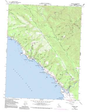
Gualala Topo Map California
To zoom in, hover over the map of Gualala
USGS Topo Quad 38123g5 - 1:24,000 scale
| Topo Map Name: | Gualala |
| USGS Topo Quad ID: | 38123g5 |
| Print Size: | ca. 21 1/4" wide x 27" high |
| Southeast Coordinates: | 38.75° N latitude / 123.5° W longitude |
| Map Center Coordinates: | 38.8125° N latitude / 123.5625° W longitude |
| U.S. State: | CA |
| Filename: | o38123g5.jpg |
| Download Map JPG Image: | Gualala topo map 1:24,000 scale |
| Map Type: | Topographic |
| Topo Series: | 7.5´ |
| Map Scale: | 1:24,000 |
| Source of Map Images: | United States Geological Survey (USGS) |
| Alternate Map Versions: |
Gualala CA 1960, updated 1961 Download PDF Buy paper map Gualala CA 1960, updated 1970 Download PDF Buy paper map Gualala CA 1960, updated 1991 Download PDF Buy paper map Gualala CA 1977, updated 1978 Download PDF Buy paper map Gualala CA 1998, updated 2002 Download PDF Buy paper map Gualala CA 2012 Download PDF Buy paper map Gualala CA 2015 Download PDF Buy paper map |
1:24,000 Topo Quads surrounding Gualala
Mallo Pass Creek |
Cold Spring |
Philo |
Boonville |
|
Point Arena |
Eureka Hill |
Zeni Ridge |
Ornbaun Valley |
|
Saunders Reef |
Gualala |
Mcguire Ridge |
Gube Mountain |
|
Stewarts Point |
Annapolis |
|||
Plantation |
> Back to 38123e1 at 1:100,000 scale
> Back to 38122a1 at 1:250,000 scale
> Back to U.S. Topo Maps home
Gualala topo map: Gazetteer
Gualala: Airports
Lofty Redwoods Airport elevation 395m 1295′Ocean Ridge Airport elevation 286m 938′
Wilsons Field elevation 55m 180′
Gualala: Bars
Robinson Reef elevation 0m 0′Gualala: Bays
Havens Anchorage elevation 0m 0′Gualala: Beaches
Cooks Beach elevation 0m 0′Fish Rock Beach elevation 27m 88′
Gualala: Capes
Gualala Point elevation 11m 36′Havens Neck elevation 14m 45′
Robinson Point elevation 9m 29′
Gualala: Flats
Elk Prairie elevation 18m 59′Wilsons Field elevation 0m 0′
Gualala: Islands
Bourns Rock elevation 0m 0′Fish Rocks elevation 0m 0′
Gualala Point Island elevation 16m 52′
Sail Rock elevation 0m 0′
Gualala: Parks
Gualala Point Regional Park elevation 23m 75′Gualala: Populated Places
Anchor Bay elevation 32m 104′Fish Rock elevation 52m 170′
Gualala elevation 15m 49′
Signal Port (historical) elevation 33m 108′
Gualala: Ridges
Fleming Ridge elevation 475m 1558′Gualala: Streams
Doty Creek elevation 67m 219′Fleming Creek elevation 121m 396′
Gualala River elevation 1m 3′
Little North Fork Gualala River elevation 9m 29′
Log Cabin Creek elevation 48m 157′
Roseman Creek elevation 22m 72′
Saint Orres Creek elevation 16m 52′
Signal Port Creek elevation 0m 0′
South Fork Garcia River elevation 55m 180′
Gualala: Valleys
Big Gulch elevation 5m 16′Bourns Gulch elevation 48m 157′
China Gulch elevation 2m 6′
China Gulch elevation 95m 311′
Ferguson Gulch elevation 27m 88′
Fish Rock Gulch elevation 7m 22′
Fox Gulch elevation 26m 85′
Getchell Gulch elevation 5m 16′
Glennen Gulch elevation 14m 45′
Hall Gulch elevation 95m 311′
Quinliven Gulch elevation 10m 32′
Robinson Gulch elevation 5m 16′
Saint Orres Gulch elevation 5m 16′
Triplett Gulch elevation 12m 39′
Gualala digital topo map on disk
Buy this Gualala topo map showing relief, roads, GPS coordinates and other geographical features, as a high-resolution digital map file on DVD:


