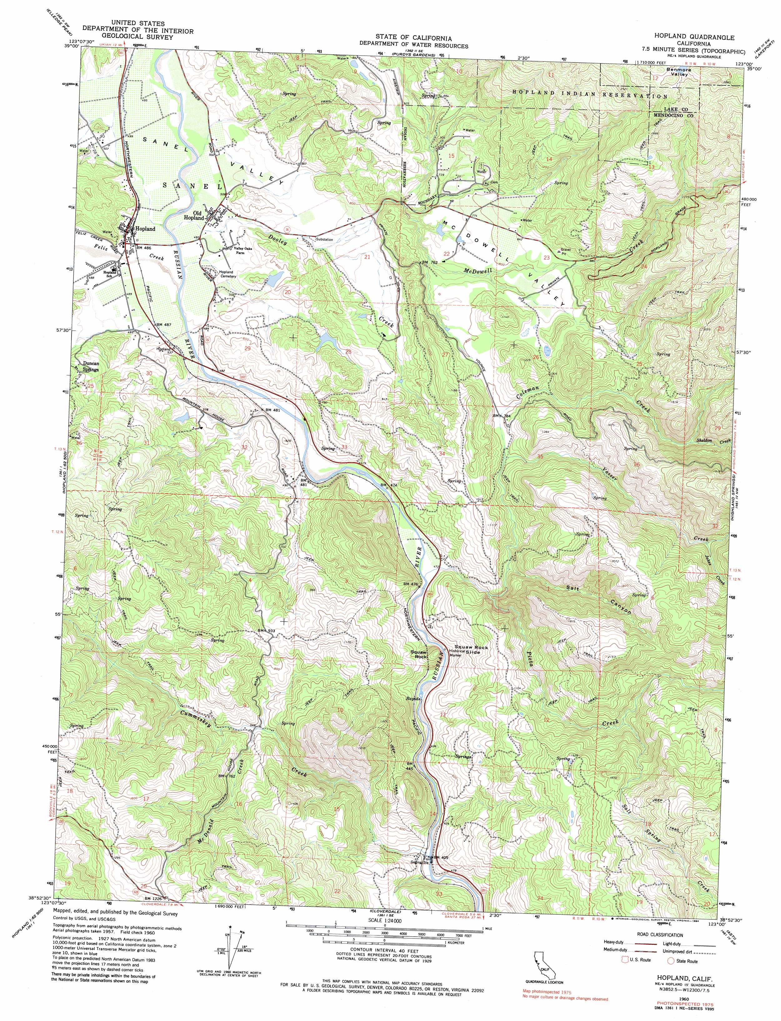
Hopland Topo Map California
To zoom in, hover over the map of Hopland
USGS Topo Quad 38123h1 - 1:24,000 scale
| Topo Map Name: | Hopland |
| USGS Topo Quad ID: | 38123h1 |
| Print Size: | ca. 21 1/4" wide x 27" high |
| Southeast Coordinates: | 38.875° N latitude / 123° W longitude |
| Map Center Coordinates: | 38.9375° N latitude / 123.0625° W longitude |
| U.S. State: | CA |
| Filename: | o38123h1.jpg |
| Download Map JPG Image: | Hopland topo map 1:24,000 scale |
| Map Type: | Topographic |
| Topo Series: | 7.5´ |
| Map Scale: | 1:24,000 |
| Source of Map Images: | United States Geological Survey (USGS) |
| Alternate Map Versions: |
Hopland CA 1960, updated 1962 Download PDF Buy paper map Hopland CA 1960, updated 1970 Download PDF Buy paper map Hopland CA 1960, updated 1984 Download PDF Buy paper map Hopland CA 2012 Download PDF Buy paper map Hopland CA 2015 Download PDF Buy paper map |
1:24,000 Topo Quads surrounding Hopland
Orrs Springs |
Ukiah |
Cow Mountain |
Upper Lake |
Bartlett Mountain |
Boonville |
Elledge Peak |
Purdys Gardens |
Lakeport |
Lucerne |
Ornbaun Valley |
Yorkville |
Hopland |
Highland Springs |
Kelseyville |
Gube Mountain |
Big Foot Mountain |
Cloverdale |
Asti |
The Geysers |
Annapolis |
Tombs Creek |
Warm Springs Dam |
Geyserville |
Jimtown |
> Back to 38123e1 at 1:100,000 scale
> Back to 38122a1 at 1:250,000 scale
> Back to U.S. Topo Maps home
Hopland topo map: Gazetteer
Hopland: Dams
Cornett 1385 Dam elevation 180m 590′Crawford Ranch 1387 Dam elevation 215m 705′
Hopland: Populated Places
Dawes elevation 152m 498′Duncan Springs elevation 238m 780′
Hopland elevation 153m 501′
Nacomis Indian Rancheria elevation 234m 767′
Oasis elevation 588m 1929′
Old Hopland elevation 152m 498′
Pieta elevation 145m 475′
Rankin (historical) elevation 478m 1568′
Hopland: Post Offices
Hopland Post Office elevation 153m 501′Hopland: Slopes
Squaw Rock Slide elevation 247m 810′Hopland: Streams
Coleman Creek elevation 187m 613′Cummiskey Creek elevation 115m 377′
Dooley Creek elevation 146m 479′
Feliz Creek elevation 147m 482′
Jakes Creek elevation 356m 1167′
McDonald Creek elevation 167m 547′
McDowell Creek elevation 557m 1827′
McDowell Valley elevation 209m 685′
Pieta Creek elevation 165m 541′
Salt Spring Creek elevation 316m 1036′
Sheldon Creek elevation 335m 1099′
Vasser Creek elevation 248m 813′
Hopland: Summits
Squaw Rock elevation 268m 879′Hopland: Valleys
Salt Canyon elevation 194m 636′Sanel Valley elevation 152m 498′
Hopland digital topo map on disk
Buy this Hopland topo map showing relief, roads, GPS coordinates and other geographical features, as a high-resolution digital map file on DVD: