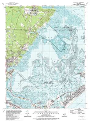
Oceanville Topo Map New Jersey
To zoom in, hover over the map of Oceanville
USGS Topo Quad 39074d4 - 1:24,000 scale
| Topo Map Name: | Oceanville |
| USGS Topo Quad ID: | 39074d4 |
| Print Size: | ca. 21 1/4" wide x 27" high |
| Southeast Coordinates: | 39.375° N latitude / 74.375° W longitude |
| Map Center Coordinates: | 39.4375° N latitude / 74.4375° W longitude |
| U.S. State: | NJ |
| Filename: | o39074d4.jpg |
| Download Map JPG Image: | Oceanville topo map 1:24,000 scale |
| Map Type: | Topographic |
| Topo Series: | 7.5´ |
| Map Scale: | 1:24,000 |
| Source of Map Images: | United States Geological Survey (USGS) |
| Alternate Map Versions: |
Oceanville NJ 1952, updated 1955 Download PDF Buy paper map Oceanville NJ 1952, updated 1969 Download PDF Buy paper map Oceanville NJ 1952, updated 1973 Download PDF Buy paper map Oceanville NJ 1989, updated 1989 Download PDF Buy paper map Oceanville NJ 1995, updated 2000 Download PDF Buy paper map Oceanville NJ 2011 Download PDF Buy paper map Oceanville NJ 2014 Download PDF Buy paper map Oceanville NJ 2016 Download PDF Buy paper map |
1:24,000 Topo Quads surrounding Oceanville
> Back to 39074a1 at 1:100,000 scale
> Back to 39074a1 at 1:250,000 scale
> Back to U.S. Topo Maps home
Oceanville topo map: Gazetteer
Oceanville: Airports
Harrahs Landing Seaplane Base elevation 0m 0′Smithville Airport (historical) elevation 11m 36′
Trumps Castle Heliport elevation 1m 3′
Oceanville: Bays
Absecon Bay elevation 0m 0′Eagle Bay elevation 0m 0′
Grassy Bay elevation 0m 0′
Hammock Cove elevation 0m 0′
Hammock Cove elevation 0m 0′
Lakes Bay elevation 0m 0′
Little Bay elevation 0m 0′
Little Bay elevation 0m 0′
Mankiller Bay elevation 0m 0′
Perch Cove elevation 0m 0′
Reeds Bay elevation 0m 0′
Somers Cove elevation 0m 0′
Turtle Cove elevation 0m 0′
Oceanville: Beaches
Peter Beach elevation 3m 9′Oceanville: Capes
Black Point elevation 0m 0′Doles Point elevation 0m 0′
Rum Point elevation 0m 0′
Oceanville: Channels
Absecon Channel elevation 0m 0′Big Fish Thorofare elevation 0m 0′
Bonita Tideway elevation 0m 0′
Broad Creek elevation 0m 0′
Clam Thorofare elevation 0m 0′
Conover Channel elevation 0m 0′
Cordery Thorofare elevation 0m 0′
Duck Thorofare elevation 0m 0′
East Point Channel elevation 0m 0′
Flat Thorofare elevation 0m 0′
Golden Hammock Thorofare elevation 0m 0′
Gull Island Thorofare elevation 0m 0′
Jonathan Thorofare elevation 0m 0′
Little Panama elevation 0m 0′
Low Water Thorofare elevation 4m 13′
Main Marsh Thorofare elevation 0m 0′
Meadow Cut elevation 3m 9′
Middle Thorofare elevation 0m 0′
Newfound Thorofare elevation 0m 0′
Obes Thorofare elevation 0m 0′
Oyster Thorofare elevation 1m 3′
Point Bar Thorofare elevation 0m 0′
Roundabout Thorofare elevation 0m 0′
Sand Thorofare elevation 0m 0′
Sheepshank Thorofare elevation 0m 0′
Sloop Thorofare elevation 0m 0′
Stake Thorofare elevation 0m 0′
Steelman Thorofare elevation 0m 0′
Wading Thorofare elevation 0m 0′
Wills Thorofare elevation 0m 0′
Oceanville: Dams
Lily Lake Dam elevation 0m 0′Oceanville: Guts
Absecon Inlet elevation 0m 0′Little Panama elevation 0m 0′
Oceanville: Harbors
State Marina elevation 0m 0′Oceanville: Islands
Boot Island elevation 1m 3′Mankiller Island elevation 0m 0′
Shad Island elevation 0m 0′
Sunflower Island elevation 0m 0′
Weakfish Island elevation 0m 0′
Oceanville: Parks
Absecon State Wildlife Management Area elevation 0m 0′Absecon State Wildlife Management Areas elevation 0m 0′
Edwin B Forsythe National Wildlife Refuge elevation 0m 0′
Green Acres Park elevation 16m 52′
Green Acres Park elevation 15m 49′
Oceanville: Populated Places
Absecon elevation 8m 26′Absecon Highlands elevation 11m 36′
Conovertown elevation 6m 19′
Leeds Point elevation 18m 59′
Oceanville elevation 12m 39′
Seaview Park elevation 3m 9′
Smithville elevation 10m 32′
Venice Park elevation 2m 6′
West Atlantic City elevation 2m 6′
Oceanville: Reservoirs
Lily Lake elevation 0m 0′Oceanville: Streams
Absecon Creek elevation 0m 0′Broad Creek elevation 0m 0′
Clam Creek elevation 0m 0′
Cordery Creek elevation 0m 0′
Doughty Creek elevation 0m 0′
Flat Creek elevation 0m 0′
Main Marsh Creek elevation 0m 0′
Mud Creek elevation 1m 3′
Rubes Creek elevation 2m 6′
Oceanville digital topo map on disk
Buy this Oceanville topo map showing relief, roads, GPS coordinates and other geographical features, as a high-resolution digital map file on DVD:
Atlantic Coast (NY, NJ, PA, DE, MD, VA, NC)
Buy digital topo maps: Atlantic Coast (NY, NJ, PA, DE, MD, VA, NC)


