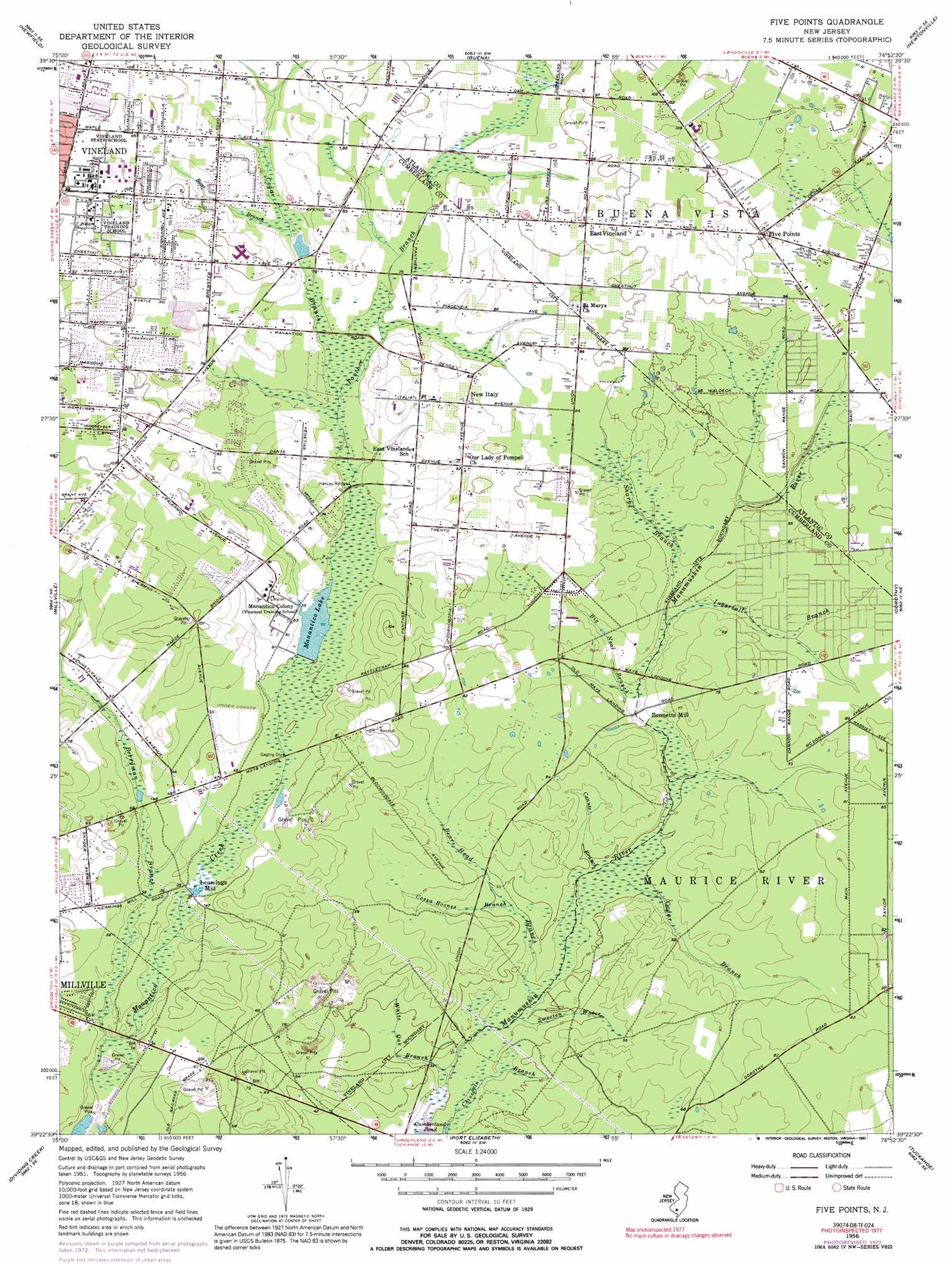
Five Points Topo Map New Jersey
To zoom in, hover over the map of Five Points
USGS Topo Quad 39074d8 - 1:24,000 scale
| Topo Map Name: | Five Points |
| USGS Topo Quad ID: | 39074d8 |
| Print Size: | ca. 21 1/4" wide x 27" high |
| Southeast Coordinates: | 39.375° N latitude / 74.875° W longitude |
| Map Center Coordinates: | 39.4375° N latitude / 74.9375° W longitude |
| U.S. State: | NJ |
| Filename: | o39074d8.jpg |
| Download Map JPG Image: | Five Points topo map 1:24,000 scale |
| Map Type: | Topographic |
| Topo Series: | 7.5´ |
| Map Scale: | 1:24,000 |
| Source of Map Images: | United States Geological Survey (USGS) |
| Alternate Map Versions: |
Five Points NJ 1956, updated 1958 Download PDF Buy paper map Five Points NJ 1956, updated 1972 Download PDF Buy paper map Five Points NJ 1956, updated 1992 Download PDF Buy paper map Five Points NJ 1994, updated 1998 Download PDF Buy paper map Five Points NJ 2011 Download PDF Buy paper map Five Points NJ 2014 Download PDF Buy paper map Five Points NJ 2016 Download PDF Buy paper map |
1:24,000 Topo Quads surrounding Five Points
Pitman West |
Pitman East |
Williamstown |
Hammonton |
Atsion |
Elmer |
Newfield |
Buena |
Newtonville |
Egg Harbor City |
Bridgeton |
Millville |
Five Points |
Dorothy |
Mays Landing |
Cedarville |
Dividing Creek |
Port Elizabeth |
Tuckahoe |
Marmora |
Fortescue |
Port Norris |
Heislerville |
Woodbine |
Sea Isle City |
> Back to 39074a1 at 1:100,000 scale
> Back to 39074a1 at 1:250,000 scale
> Back to U.S. Topo Maps home
Five Points topo map: Gazetteer
Five Points: Airports
Free Spirit Airport elevation 24m 78′J L Gentile Heliport elevation 27m 88′
Five Points: Bridges
Hances Bridge elevation 18m 59′Five Points: Dams
Memorial Park Pond Dam elevation 22m 72′Menantico Dam elevation 15m 49′
Five Points: Populated Places
Bennetts Mill elevation 18m 59′East Vineland elevation 32m 104′
Five Points elevation 30m 98′
Leamings Mill elevation 9m 29′
New Italy elevation 27m 88′
Five Points: Reservoirs
Memorial Park Pond elevation 22m 72′Menantico Lake elevation 15m 49′
Five Points: Streams
Bear Branch elevation 22m 72′Bears Head Branch elevation 11m 36′
Berryman Branch elevation 4m 13′
Big Neal Branch elevation 16m 52′
Canute Branch elevation 13m 42′
Cedar Branch elevation 20m 65′
Cedar Branch elevation 14m 45′
Chincopin Branch elevation 10m 32′
Cossa Boones Branch elevation 14m 45′
Ingersall Branch elevation 18m 59′
Panther Branch elevation 20m 65′
Sharps Branch elevation 19m 62′
Sweeten Water elevation 11m 36′
White Oak Branch elevation 9m 29′
Five Points digital topo map on disk
Buy this Five Points topo map showing relief, roads, GPS coordinates and other geographical features, as a high-resolution digital map file on DVD:
Atlantic Coast (NY, NJ, PA, DE, MD, VA, NC)
Buy digital topo maps: Atlantic Coast (NY, NJ, PA, DE, MD, VA, NC)
 map DVD")