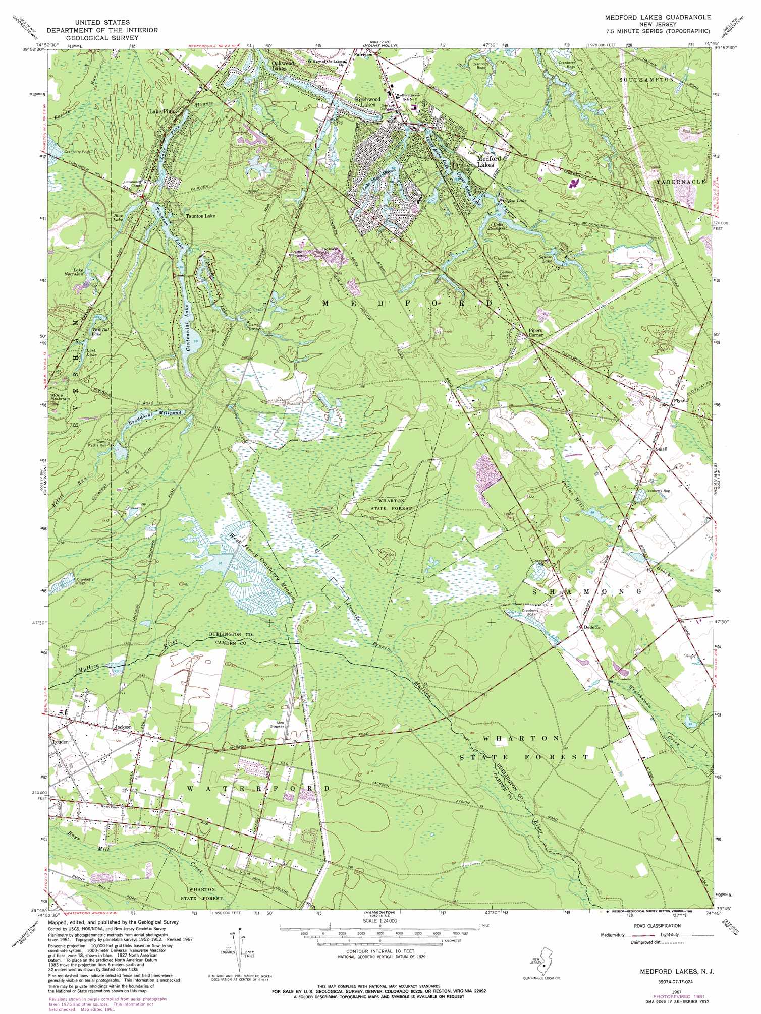
Medford Lakes Topo Map New Jersey
To zoom in, hover over the map of Medford Lakes
USGS Topo Quad 39074g7 - 1:24,000 scale
| Topo Map Name: | Medford Lakes |
| USGS Topo Quad ID: | 39074g7 |
| Print Size: | ca. 21 1/4" wide x 27" high |
| Southeast Coordinates: | 39.75° N latitude / 74.75° W longitude |
| Map Center Coordinates: | 39.8125° N latitude / 74.8125° W longitude |
| U.S. State: | NJ |
| Filename: | o39074g7.jpg |
| Download Map JPG Image: | Medford Lakes topo map 1:24,000 scale |
| Map Type: | Topographic |
| Topo Series: | 7.5´ |
| Map Scale: | 1:24,000 |
| Source of Map Images: | United States Geological Survey (USGS) |
| Alternate Map Versions: |
Medford Lakes NJ 1953, updated 1954 Download PDF Buy paper map Medford Lakes NJ 1953, updated 1960 Download PDF Buy paper map Medford Lakes NJ 1967, updated 1968 Download PDF Buy paper map Medford Lakes NJ 1967, updated 1972 Download PDF Buy paper map Medford Lakes NJ 1967, updated 1982 Download PDF Buy paper map Medford Lakes NJ 1967, updated 1988 Download PDF Buy paper map Medford Lakes NJ 2011 Download PDF Buy paper map Medford Lakes NJ 2014 Download PDF Buy paper map Medford Lakes NJ 2016 Download PDF Buy paper map |
1:24,000 Topo Quads surrounding Medford Lakes
Frankford |
Beverly |
Bristol |
Columbus |
New Egypt |
Camden |
Moorestown |
Mount Holly |
Pemberton |
Browns Mills |
Runnemede |
Clementon |
Medford Lakes |
Indian Mills |
Chatsworth |
Pitman East |
Williamstown |
Hammonton |
Atsion |
Jenkins |
Newfield |
Buena |
Newtonville |
Egg Harbor City |
Green Bank |
> Back to 39074e1 at 1:100,000 scale
> Back to 39074a1 at 1:250,000 scale
> Back to U.S. Topo Maps home
Medford Lakes topo map: Gazetteer
Medford Lakes: Airports
Indian Mills Heliport elevation 25m 82′Medford Lakes: Dams
Birchwood Lake Dam elevation 12m 39′Braddocks Mill Dam elevation 21m 68′
Breakneck Dam elevation 15m 49′
Centennial Lake Dam elevation 15m 49′
Lower Aetna Lake Dam elevation 16m 52′
Mishe-Mokwa Dam elevation 19m 62′
Pine Lake Dam elevation 12m 39′
Timber Lake Dam elevation 13m 42′
Upper Aetna Lake Dam elevation 19m 62′
Upper Stokes Dam elevation 25m 82′
Medford Lakes: Lakes
Lake Pine elevation 12m 39′Medford Lakes: Populated Places
Birchwood Lakes elevation 15m 49′Braddocks Mill elevation 22m 72′
Dellette elevation 26m 85′
Fairview elevation 17m 55′
Flyat elevation 27m 88′
Jackson elevation 37m 121′
Lake Pine elevation 15m 49′
Louden elevation 44m 144′
Medford Lakes elevation 23m 75′
Oakwood Lakes elevation 13m 42′
Pipers Corner elevation 34m 111′
Taunton Lake elevation 20m 65′
Medford Lakes: Reservoirs
Birchwood Lake elevation 12m 39′Blue Lake elevation 15m 49′
Braddocks Millpond elevation 21m 68′
Centennial Lake elevation 15m 49′
Lake Mishe-Mokwa elevation 19m 62′
Lake Norrsken elevation 20m 65′
Lake Pine elevation 12m 39′
Lake Stockwell elevation 19m 62′
Lost Lake elevation 23m 75′
Lower Aetna Lake elevation 16m 52′
Mimosa Lakes elevation 16m 52′
Papoose Lake elevation 19m 62′
Squaw Lake elevation 22m 72′
Taunton Lake elevation 15m 49′
Timber Lake elevation 13m 42′
Upper Aetna Lake elevation 19m 62′
Upper Stokes Pond elevation 25m 82′
Van Dal Lake elevation 18m 59′
Medford Lakes: Streams
Alquatka Branch elevation 24m 78′Black Run elevation 15m 49′
Kettle Run elevation 27m 88′
Medford Lakes: Summits
Jackson Hill elevation 45m 147′Sharps Mountain elevation 38m 124′
Stone Mountain elevation 50m 164′
Medford Lakes: Swamps
West Jersey Cranberry Meadow elevation 27m 88′Medford Lakes digital topo map on disk
Buy this Medford Lakes topo map showing relief, roads, GPS coordinates and other geographical features, as a high-resolution digital map file on DVD:
Atlantic Coast (NY, NJ, PA, DE, MD, VA, NC)
Buy digital topo maps: Atlantic Coast (NY, NJ, PA, DE, MD, VA, NC)
 map DVD")