Pemberton Topo Map New Jersey
To zoom in, hover over the map of Pemberton
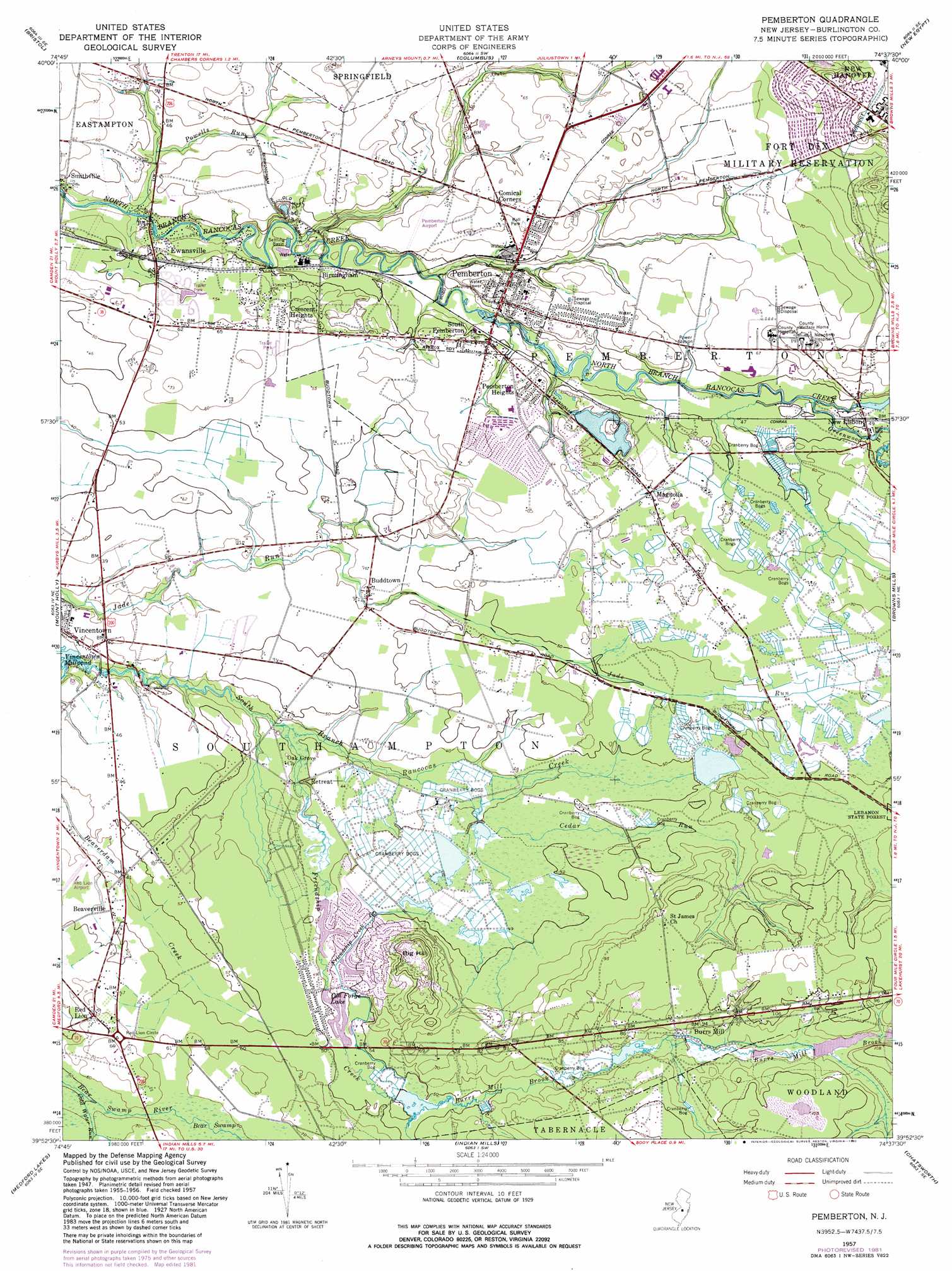
USGS Topo Quad 39074h6 - 1:24,000 scale
| Topo Map Name: | Pemberton |
| USGS Topo Quad ID: | 39074h6 |
| Print Size: | ca. 21 1/4" wide x 27" high |
| Southeast Coordinates: | 39.875° N latitude / 74.625° W longitude |
| Map Center Coordinates: | 39.9375° N latitude / 74.6875° W longitude |
| U.S. State: | NJ |
| Filename: | o39074h6.jpg |
| Download Map JPG Image: | Pemberton topo map 1:24,000 scale |
| Map Type: | Topographic |
| Topo Series: | 7.5´ |
| Map Scale: | 1:24,000 |
| Source of Map Images: | United States Geological Survey (USGS) |
| Alternate Map Versions: |
Pemberton NJ 1949, updated 1959 Download PDF Buy paper map Pemberton NJ 1951 Download PDF Buy paper map Pemberton NJ 1951 Download PDF Buy paper map Pemberton NJ 1957, updated 1961 Download PDF Buy paper map Pemberton NJ 1957, updated 1969 Download PDF Buy paper map Pemberton NJ 1957, updated 1971 Download PDF Buy paper map Pemberton NJ 1957, updated 1982 Download PDF Buy paper map Pemberton NJ 2011 Download PDF Buy paper map Pemberton NJ 2014 Download PDF Buy paper map Pemberton NJ 2016 Download PDF Buy paper map |
1:24,000 Topo Quads surrounding Pemberton
Langhorne |
Trenton West |
Trenton East |
Allentown |
Roosevelt |
Beverly |
Bristol |
Columbus |
New Egypt |
Cassville |
Moorestown |
Mount Holly |
Pemberton |
Browns Mills |
Whiting |
Clementon |
Medford Lakes |
Indian Mills |
Chatsworth |
Woodmansie |
Williamstown |
Hammonton |
Atsion |
Jenkins |
Oswego Lake |
> Back to 39074e1 at 1:100,000 scale
> Back to 39074a1 at 1:250,000 scale
> Back to U.S. Topo Maps home
Pemberton topo map: Gazetteer
Pemberton: Airports
Pemberton Airport elevation 20m 65′Red Lion Airport elevation 13m 42′
Pemberton: Dams
Gravelly Run Dam elevation 15m 49′Huntington Drive Dam elevation 11m 36′
Lisbon Dam elevation 13m 42′
New Lisbon Mill Dam elevation 13m 42′
Pemberton: Mines
Marl Pit elevation 7m 22′Pemberton: Populated Places
Beaverville elevation 13m 42′Birmingham elevation 10m 32′
Buddtown elevation 12m 39′
Burrs Mill elevation 27m 88′
Comical Corners elevation 21m 68′
Crescent Heights elevation 20m 65′
Ewansville elevation 12m 39′
Hampton Lakes elevation 12m 39′
Leisuretowne elevation 19m 62′
Magnolia elevation 18m 59′
New Lisbon elevation 13m 42′
Pemberton elevation 18m 59′
Pemberton Heights elevation 20m 65′
Red Lion elevation 19m 62′
Retreat elevation 9m 29′
Scrapetown elevation 25m 82′
Scratch Ridge elevation 20m 65′
Smithville elevation 13m 42′
South Pemberton elevation 16m 52′
Vincentown elevation 12m 39′
Pemberton: Reservoirs
Burrs Mill Brook Reservoir elevation 22m 72′Gravelly Run Pond elevation 15m 49′
Lake Three elevation 11m 36′
Old Forge Lake elevation 11m 36′
Pemberton: Streams
Beaverdam Creek elevation 11m 36′Budd Run elevation 8m 26′
Burrs Mill Brook elevation 14m 45′
Cedar Run elevation 12m 39′
Cold Water Run elevation 15m 49′
Friendship Creek elevation 8m 26′
Friendship Creek Branch elevation 15m 49′
Greenwood Branch elevation 11m 36′
Powells Run elevation 7m 22′
Pemberton: Summits
Big Hill elevation 37m 121′Pemberton digital topo map on disk
Buy this Pemberton topo map showing relief, roads, GPS coordinates and other geographical features, as a high-resolution digital map file on DVD:
Atlantic Coast (NY, NJ, PA, DE, MD, VA, NC)
Buy digital topo maps: Atlantic Coast (NY, NJ, PA, DE, MD, VA, NC)
 map DVD")