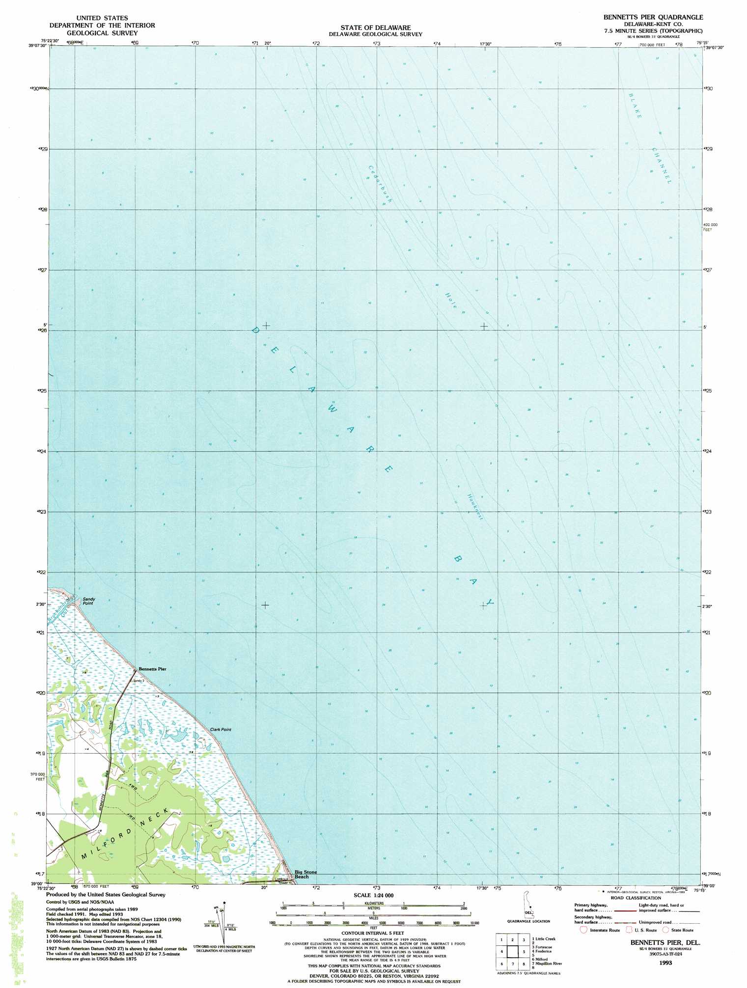
Bennetts Pier Topo Map Delaware
To zoom in, hover over the map of Bennetts Pier
USGS Topo Quad 39075a3 - 1:24,000 scale
| Topo Map Name: | Bennetts Pier |
| USGS Topo Quad ID: | 39075a3 |
| Print Size: | ca. 21 1/4" wide x 27" high |
| Southeast Coordinates: | 39° N latitude / 75.25° W longitude |
| Map Center Coordinates: | 39.0625° N latitude / 75.3125° W longitude |
| U.S. State: | DE |
| Filename: | o39075a3.jpg |
| Download Map JPG Image: | Bennetts Pier topo map 1:24,000 scale |
| Map Type: | Topographic |
| Topo Series: | 7.5´ |
| Map Scale: | 1:24,000 |
| Source of Map Images: | United States Geological Survey (USGS) |
| Alternate Map Versions: |
Bennetts Pier DE 1949 Download PDF Buy paper map Bennett's Pier DE 1949 Download PDF Buy paper map Bennetts Pier DE 1956, updated 1957 Download PDF Buy paper map Bennetts Pier DE 1956, updated 1957 Download PDF Buy paper map Bennetts Pier DE 1993, updated 1993 Download PDF Buy paper map Bennetts Pier DE 2011 Download PDF Buy paper map Bennetts Pier DE 2014 Download PDF Buy paper map Bennetts Pier DE 2016 Download PDF Buy paper map |
1:24,000 Topo Quads surrounding Bennetts Pier
Smyrna |
Bombay Hook |
Ben Davis Point |
Cedarville |
Dividing Creek |
Dover |
Little Creek |
Fortescue |
Port Norris |
|
Wyoming |
Frederica |
Bennetts Pier |
||
Harrington |
Milford |
Mispillion River |
||
Greenwood |
Ellendale |
Milton |
Lewes |
Cape Henlopen |
> Back to 39075a1 at 1:100,000 scale
> Back to 39074a1 at 1:250,000 scale
> Back to U.S. Topo Maps home
Bennetts Pier topo map: Gazetteer
Bennetts Pier: Areas
Cedarbush Hole elevation 0m 0′Bennetts Pier: Bars
Hawknest elevation 0m 0′The Inner Fork of the Shears (historical) elevation 0m 0′
Bennetts Pier: Capes
Clark Point elevation 0m 0′Sandy Point elevation 0m 0′
Bennetts Pier: Channels
Blake Channel elevation 0m 0′Bennetts Pier: Guts
Clarks Ditch (historical) elevation 1m 3′Bennetts Pier: Populated Places
Frenchs Mobile Homes elevation 3m 9′Bennetts Pier: Streams
Hawks Inlet (historical) elevation 1m 3′Bennetts Pier digital topo map on disk
Buy this Bennetts Pier topo map showing relief, roads, GPS coordinates and other geographical features, as a high-resolution digital map file on DVD:
Atlantic Coast (NY, NJ, PA, DE, MD, VA, NC)
Buy digital topo maps: Atlantic Coast (NY, NJ, PA, DE, MD, VA, NC)
 map DVD")