Church Hill Topo Map Maryland
To zoom in, hover over the map of Church Hill
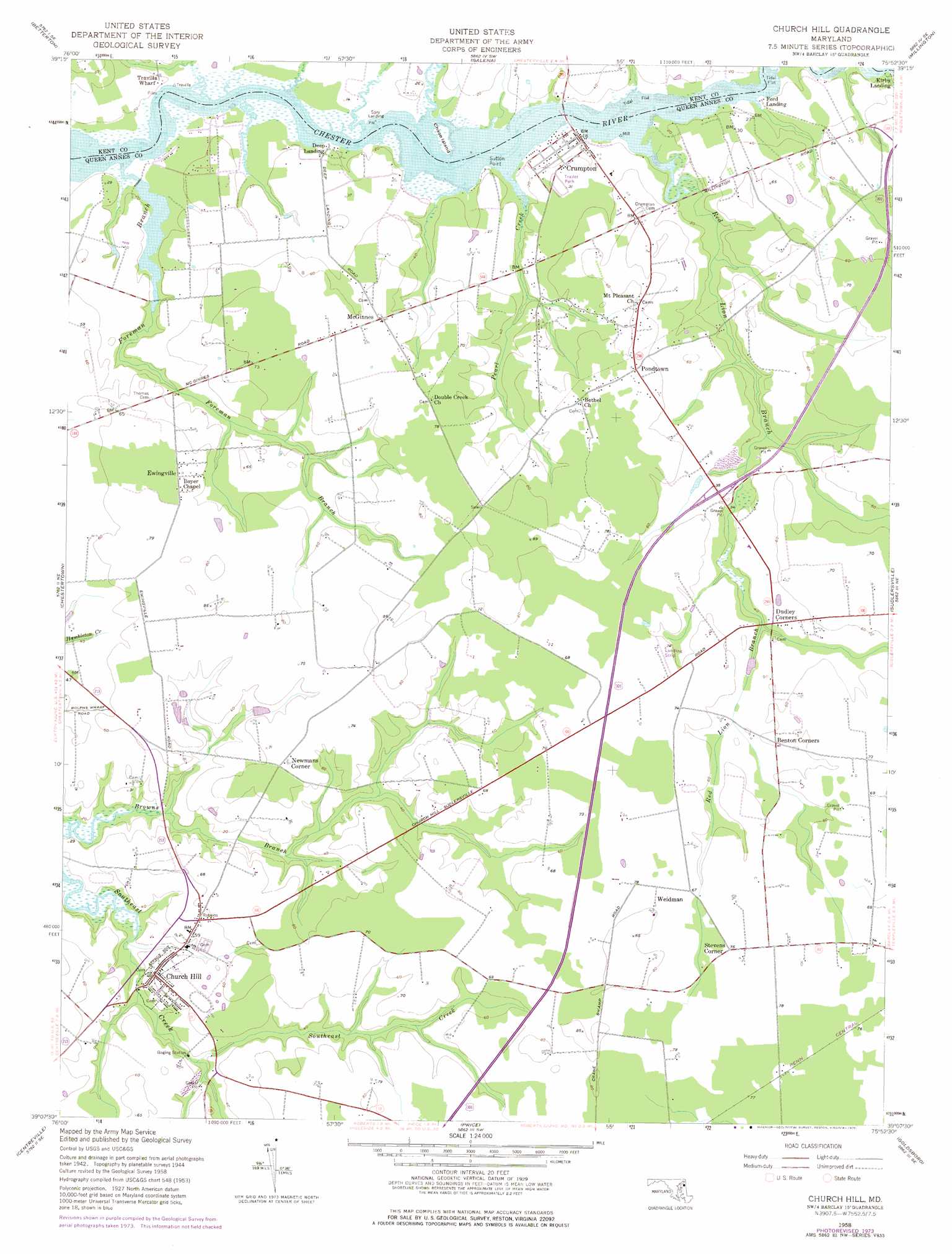
USGS Topo Quad 39075b8 - 1:24,000 scale
| Topo Map Name: | Church Hill |
| USGS Topo Quad ID: | 39075b8 |
| Print Size: | ca. 21 1/4" wide x 27" high |
| Southeast Coordinates: | 39.125° N latitude / 75.875° W longitude |
| Map Center Coordinates: | 39.1875° N latitude / 75.9375° W longitude |
| U.S. State: | MD |
| Filename: | o39075b8.jpg |
| Download Map JPG Image: | Church Hill topo map 1:24,000 scale |
| Map Type: | Topographic |
| Topo Series: | 7.5´ |
| Map Scale: | 1:24,000 |
| Source of Map Images: | United States Geological Survey (USGS) |
| Alternate Map Versions: |
Church Hill MD 1958, updated 1959 Download PDF Buy paper map Church Hill MD 1958, updated 1976 Download PDF Buy paper map Church Hill MD 2011 Download PDF Buy paper map Church Hill MD 2014 Download PDF Buy paper map Church Hill MD 2017 Download PDF Buy paper map |
1:24,000 Topo Quads surrounding Church Hill
Perryman |
Spesutie |
Earleville |
Cecilton |
Middletown |
Hanesville |
Betterton |
Galena |
Millington |
Clayton |
Rock Hall |
Chestertown |
Church Hill |
Sudlersville |
Kenton |
Langford Creek |
Centreville |
Price |
Goldsboro |
Marydel |
Queenstown |
Wye Mills |
Ridgely |
Denton |
Burrsville |
> Back to 39075a1 at 1:100,000 scale
> Back to 39074a1 at 1:250,000 scale
> Back to U.S. Topo Maps home
Church Hill topo map: Gazetteer
Church Hill: Airports
Flying Acres Airport elevation 18m 59′Church Hill: Capes
Bluff Point elevation 1m 3′Sutton Point elevation 1m 3′
Church Hill: Crossings
Callisters Ferry (historical) elevation 0m 0′Church Hill: Islands
Chase Island elevation 0m 0′Church Hill: Parks
Crumpton Park elevation 10m 32′Pinkney Park elevation 18m 59′
Church Hill: Populated Places
Ben Lee Estates elevation 19m 62′Char-Nor Manor elevation 6m 19′
Church Hill elevation 12m 39′
Cronshaw elevation 13m 42′
Crumpton elevation 3m 9′
Deep Landing elevation 0m 0′
Double Creek Wood elevation 6m 19′
Dudley Corners elevation 12m 39′
Ewingville elevation 18m 59′
Ford Landing elevation 4m 13′
Kirby Landing elevation 1m 3′
McGinnes elevation 20m 65′
Mussel Shoals elevation 6m 19′
Newmans Corner elevation 19m 62′
Pheasantfield elevation 6m 19′
Pine Cove elevation 6m 19′
Pine Springs Mobile Home Park elevation 8m 26′
Piney Shores elevation 6m 19′
Pondtown elevation 18m 59′
Sagefield elevation 17m 55′
Springview elevation 17m 55′
Spry Landing elevation 1m 3′
Stevens Corner elevation 21m 68′
The Meadows elevation 17m 55′
The Village at Church Hill Crossing elevation 11m 36′
Weidman elevation 24m 78′
Church Hill: Post Offices
Church Hill Post Office (historical) elevation 13m 42′Crumpton Post Office elevation 6m 19′
Church Hill: Streams
Birres Creek elevation 1m 3′Chesterville Branch elevation 0m 0′
Foreman Branch elevation 0m 0′
Goosehaven Creek elevation 0m 0′
Norris Creek elevation 0m 0′
Pearl Creek elevation 0m 0′
Prickly Pear Creek elevation 3m 9′
Red Lion Branch elevation 0m 0′
Rowsbys Branch elevation 12m 39′
Church Hill digital topo map on disk
Buy this Church Hill topo map showing relief, roads, GPS coordinates and other geographical features, as a high-resolution digital map file on DVD:
Atlantic Coast (NY, NJ, PA, DE, MD, VA, NC)
Buy digital topo maps: Atlantic Coast (NY, NJ, PA, DE, MD, VA, NC)
 map DVD")