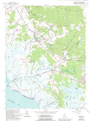
Cedarville Topo Map New Jersey
To zoom in, hover over the map of Cedarville
USGS Topo Quad 39075c2 - 1:24,000 scale
| Topo Map Name: | Cedarville |
| USGS Topo Quad ID: | 39075c2 |
| Print Size: | ca. 21 1/4" wide x 27" high |
| Southeast Coordinates: | 39.25° N latitude / 75.125° W longitude |
| Map Center Coordinates: | 39.3125° N latitude / 75.1875° W longitude |
| U.S. State: | NJ |
| Filename: | o39075c2.jpg |
| Download Map JPG Image: | Cedarville topo map 1:24,000 scale |
| Map Type: | Topographic |
| Topo Series: | 7.5´ |
| Map Scale: | 1:24,000 |
| Source of Map Images: | United States Geological Survey (USGS) |
| Alternate Map Versions: |
Cedarville NJ 1956, updated 1958 Download PDF Buy paper map Cedarville NJ 1956, updated 1969 Download PDF Buy paper map Cedarville NJ 1956, updated 1973 Download PDF Buy paper map Cedarville NJ 1956, updated 1980 Download PDF Buy paper map Cedarville NJ 1956, updated 1984 Download PDF Buy paper map Cedarville NJ 1956, updated 1993 Download PDF Buy paper map Cedarville NJ 2011 Download PDF Buy paper map Cedarville NJ 2014 Download PDF Buy paper map Cedarville NJ 2016 Download PDF Buy paper map |
1:24,000 Topo Quads surrounding Cedarville
> Back to 39075a1 at 1:100,000 scale
> Back to 39074a1 at 1:250,000 scale
> Back to U.S. Topo Maps home
Cedarville topo map: Gazetteer
Cedarville: Airports
Youngs Landing Field elevation 3m 9′Cedarville: Bays
Dyer Cove elevation -1m -4′Cedarville: Capes
Bradford Point elevation 3m 9′Fortescue Neck elevation 3m 9′
Iron Point elevation 3m 9′
Money Island elevation 3m 9′
Nantuxent Point elevation 0m 0′
Newport Neck elevation 3m 9′
Turkey Point elevation 3m 9′
Cedarville: Dams
Cedar Lake Dam elevation 3m 9′Lummis Lake Lower Dam elevation 8m 26′
Shaws Mill Pond Dam elevation 6m 19′
Cedarville: Flats
The Glades elevation -1m -4′Cedarville: Guts
Blackbird Gut elevation 3m 9′Blizzard Neck Gut elevation 3m 9′
Eagle Island Gut elevation 3m 9′
Grandad Gut elevation 3m 9′
Hay Gut elevation 3m 9′
Lone Tree Creek elevation 3m 9′
Lopers Gut elevation 3m 9′
Nancy Gut elevation 3m 9′
Rattlesnake Gut elevation 13m 42′
Cedarville: Islands
Fortescue Island (historical) elevation 3m 9′Jones Island elevation 3m 9′
Lores Island elevation 3m 9′
Cedarville: Lakes
Sheepkill Pond elevation 0m 0′Wallens Pond elevation 0m 0′
Cedarville: Parks
Fortescue Fish and Wildlife Management Area elevation 3m 9′Nantuxent Fish and Wildlife Management Area elevation 3m 9′
Cedarville: Populated Places
Cedarville elevation 8m 26′Frames Corner elevation 3m 9′
Gandys Beach elevation 3m 9′
Lummistown elevation 14m 45′
New England Crossroads elevation 9m 29′
Newport elevation 3m 9′
Newport Landing elevation 3m 9′
Shaws Mill elevation 4m 13′
Turkey Point Corner elevation 3m 9′
Watsons Corner elevation 3m 9′
Cedarville: Reservoirs
Cedar Lake elevation 3m 9′Lummis Lakes elevation 9m 29′
Shaws Mill Pond elevation 6m 19′
Cedarville: Ridges
Cabin Ridge elevation 3m 9′Cedarville: Streams
Beach Creek elevation 0m 0′Boggy Branch elevation 8m 26′
Bowers Creek elevation 3m 9′
Cedar Branch elevation 8m 26′
Dyer Creek elevation 1m 3′
Howells Creek elevation 3m 9′
Iron Branch elevation 0m 0′
Little Pond Creek elevation 1m 3′
Middle Brook elevation -5m -17′
Mile Branch elevation 8m 26′
Nantuxent Creek elevation -3m -10′
Padgetts Creek elevation 3m 9′
Pages Run elevation -5m -17′
Ponds Creek elevation 3m 9′
Sow and Pigs Creek elevation 0m 0′
Weir Creek elevation 2m 6′
Cedarville: Swamps
Bear Swamp elevation 3m 9′Coon Trap elevation 3m 9′
Cedarville digital topo map on disk
Buy this Cedarville topo map showing relief, roads, GPS coordinates and other geographical features, as a high-resolution digital map file on DVD:
Atlantic Coast (NY, NJ, PA, DE, MD, VA, NC)
Buy digital topo maps: Atlantic Coast (NY, NJ, PA, DE, MD, VA, NC)


