Canton Topo Map New Jersey
To zoom in, hover over the map of Canton
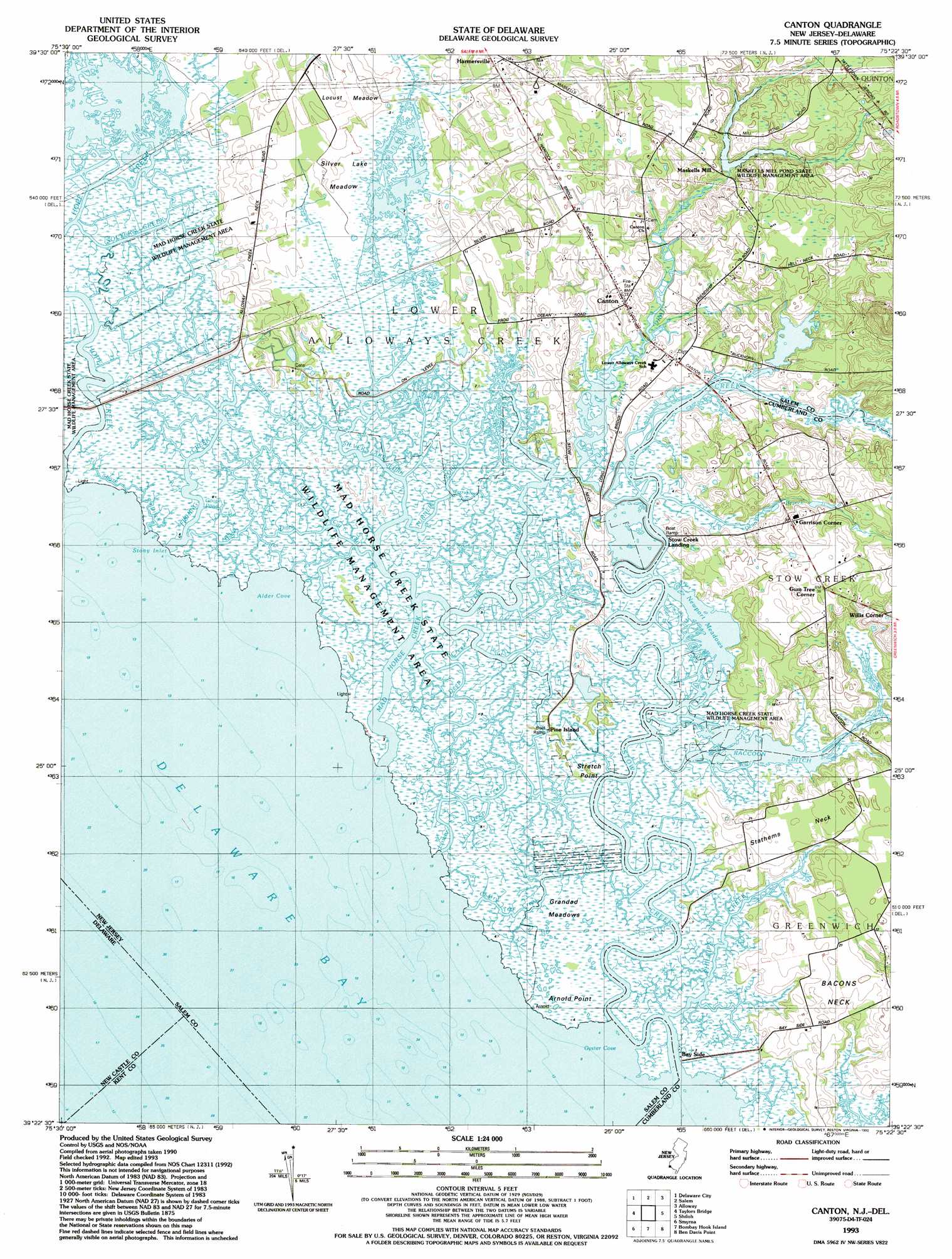
USGS Topo Quad 39075d4 - 1:24,000 scale
| Topo Map Name: | Canton |
| USGS Topo Quad ID: | 39075d4 |
| Print Size: | ca. 21 1/4" wide x 27" high |
| Southeast Coordinates: | 39.375° N latitude / 75.375° W longitude |
| Map Center Coordinates: | 39.4375° N latitude / 75.4375° W longitude |
| U.S. States: | NJ, DE |
| Filename: | o39075d4.jpg |
| Download Map JPG Image: | Canton topo map 1:24,000 scale |
| Map Type: | Topographic |
| Topo Series: | 7.5´ |
| Map Scale: | 1:24,000 |
| Source of Map Images: | United States Geological Survey (USGS) |
| Alternate Map Versions: |
Canton NJ 1948, updated 1965 Download PDF Buy paper map Canton NJ 1948, updated 1969 Download PDF Buy paper map Canton NJ 1948, updated 1972 Download PDF Buy paper map Canton NJ 1949 Download PDF Buy paper map Canton NJ 1993, updated 1993 Download PDF Buy paper map Canton NJ 2011 Download PDF Buy paper map Canton NJ 2014 Download PDF Buy paper map Canton NJ 2016 Download PDF Buy paper map |
1:24,000 Topo Quads surrounding Canton
Newark East |
Wilmington South |
Penns Grove |
Woodstown |
Pitman West |
Saint Georges |
Delaware City |
Salem |
Alloway |
Elmer |
Middletown |
Taylors Bridge |
Canton |
Shiloh |
Bridgeton |
Clayton |
Smyrna |
Bombay Hook |
Ben Davis Point |
Cedarville |
Kenton |
Dover |
Little Creek |
Fortescue |
> Back to 39075a1 at 1:100,000 scale
> Back to 39074a1 at 1:250,000 scale
> Back to U.S. Topo Maps home
Canton topo map: Gazetteer
Canton: Airports
Newport Meadows Seaplane Base elevation 0m 0′Canton: Bays
Alder Cove elevation -2m -7′Oyster Cove elevation -3m -10′
Stony Inlet elevation -2m -7′
Canton: Canals
Bucks Ditch elevation 0m 0′Raccoon Ditch elevation 0m 0′
Shore Ditch elevation 1m 3′
Canton: Capes
Arnold Point elevation 2m 6′Bacons Neck elevation 6m 19′
Stathems Neck elevation 5m 16′
Stretch Point elevation 1m 3′
Canton: Dams
Maskells Millpond Dam elevation 5m 16′Canton: Flats
Locust Meadow elevation 3m 9′Silver Lake Meadow elevation 1m 3′
Canton: Guts
Cat Gut elevation 0m 0′Devils Gut elevation 0m 0′
Lower Deep Creek elevation 0m 0′
Silver Lake Fork elevation 0m 0′
Terrapin Gut elevation 1m 3′
Upper Deep Creek elevation 1m 3′
Canton: Lakes
Goose Pond elevation 0m 0′Long Pond elevation 0m 0′
Newport Meadows elevation 0m 0′
Canton: Parks
Mad Horse Creek Fish and Wildlife Management Area elevation 2m 6′Maskells Millpond Fish and Wildlife Management Area elevation 2m 6′
Canton: Populated Places
Bay Side elevation 1m 3′Canton elevation 6m 19′
Garrison Corner elevation 9m 29′
Gum Tree Corner elevation 12m 39′
Harmersville elevation 3m 9′
Maskells Mill elevation 4m 13′
Pine Island elevation 1m 3′
Stow Creek Landing elevation 1m 3′
Willis Corner elevation 10m 32′
Canton: Reservoirs
Maskells Millpond elevation 5m 16′Canton: Streams
Canton Drain elevation 1m 3′Cherry Tree Creek elevation 0m 0′
Denn Branch elevation 0m 0′
Fishing Creek elevation 2m 6′
Little Creek elevation 0m 0′
Mad Horse Creek elevation -1m -4′
Malapartis Creek elevation 1m 3′
Muddy Creek elevation 2m 6′
Pattys Fork elevation 0m 0′
Phillips Creek elevation 0m 0′
Solters Creek elevation 0m 0′
Stow Creek elevation 0m 0′
Turner Fork elevation 0m 0′
Canton: Swamps
Grandad Meadows elevation 1m 3′Canton digital topo map on disk
Buy this Canton topo map showing relief, roads, GPS coordinates and other geographical features, as a high-resolution digital map file on DVD:
Atlantic Coast (NY, NJ, PA, DE, MD, VA, NC)
Buy digital topo maps: Atlantic Coast (NY, NJ, PA, DE, MD, VA, NC)
 map DVD")