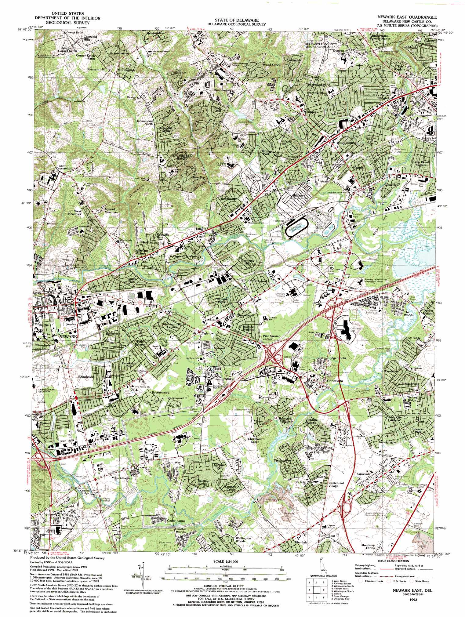
Newark East Topo Map Delaware
To zoom in, hover over the map of Newark East
USGS Topo Quad 39075f6 - 1:24,000 scale
| Topo Map Name: | Newark East |
| USGS Topo Quad ID: | 39075f6 |
| Print Size: | ca. 21 1/4" wide x 27" high |
| Southeast Coordinates: | 39.625° N latitude / 75.625° W longitude |
| Map Center Coordinates: | 39.6875° N latitude / 75.6875° W longitude |
| U.S. State: | DE |
| Filename: | o39075f6.jpg |
| Download Map JPG Image: | Newark East topo map 1:24,000 scale |
| Map Type: | Topographic |
| Topo Series: | 7.5´ |
| Map Scale: | 1:24,000 |
| Source of Map Images: | United States Geological Survey (USGS) |
| Alternate Map Versions: |
Newark East DE 1953, updated 1955 Download PDF Buy paper map Newark East DE 1953, updated 1964 Download PDF Buy paper map Newark East DE 1953, updated 1971 Download PDF Buy paper map Newark East DE 1953, updated 1985 Download PDF Buy paper map Newark East DE 1993, updated 1993 Download PDF Buy paper map Newark East DE 1993, updated 1993 Download PDF Buy paper map Newark East DE 2011 Download PDF Buy paper map Newark East DE 2014 Download PDF Buy paper map Newark East DE 2016 Download PDF Buy paper map |
1:24,000 Topo Quads surrounding Newark East
Parkesburg |
Coatesville |
Unionville |
West Chester |
Media |
Oxford |
West Grove |
Kennett Square |
Wilmington North |
Marcus Hook |
Bay View |
Newark West |
Newark East |
Wilmington South |
Penns Grove |
North East |
Elkton |
Saint Georges |
Delaware City |
Salem |
Earleville |
Cecilton |
Middletown |
Taylors Bridge |
Canton |
> Back to 39075e1 at 1:100,000 scale
> Back to 39074a1 at 1:250,000 scale
> Back to U.S. Topo Maps home
Newark East topo map: Gazetteer
Newark East: Airports
Du Pont Instruments Products Airport elevation 10m 32′Strawbridge Christiana Mall Helipad elevation 27m 88′
Newark East: Crossings
Interchange 1A and 1B elevation 24m 78′Interchange 3 elevation 25m 82′
Interchange 4A and 4B elevation 23m 75′
Newark East: Islands
Bread and Cheese Island elevation 5m 16′Newark East: Parks
Brandywine Springs State Park elevation 33m 108′Carousel Farm Park elevation 66m 216′
Cobbs-Gauger Park elevation 21m 68′
Coventry Ridge Park elevation 3m 9′
Eastburn Acres Park elevation 11m 36′
Gallaher School Park elevation 25m 82′
Glendale Park elevation 58m 190′
Kells Park elevation 30m 98′
Leathermans Run Park elevation 14m 45′
Lewden Green Park elevation 3m 9′
Lewis Park elevation 31m 101′
Lumbrook Park elevation 31m 101′
McKees Park elevation 22m 72′
Middle Run Valley Park elevation 51m 167′
Middle Run Valley Park elevation 47m 154′
Pleasant Hills Park elevation 3m 9′
Powell Ford Park elevation 13m 42′
Stafford Park elevation 31m 101′
University of Delaware Bob Hannah Stadium elevation 29m 95′
University of Delaware David M Nelson Athletic Complex elevation 31m 101′
University of Delaware Rullo Stadium elevation 30m 98′
University of Delaware Stadium elevation 29m 95′
White Chapel Park elevation 22m 72′
Newark East: Populated Places
Albertson elevation 34m 111′Albertson Park elevation 36m 118′
Albion elevation 12m 39′
Arbor Pointe Apartments elevation 11m 36′
Arundel elevation 56m 183′
Bear elevation 21m 68′
Beechers Lot elevation 18m 59′
Belford Manor elevation 37m 121′
Birch Pointe elevation 36m 118′
Birchwood Park elevation 23m 75′
Brandywine Springs elevation 49m 160′
Brandywine Springs Manor elevation 42m 137′
Breezewood II elevation 24m 78′
Brookbend elevation 27m 88′
Brookhaven elevation 16m 52′
Brookmont Farms elevation 21m 68′
Brookside elevation 23m 75′
Capital Trail Farms elevation 29m 95′
Carousel Knoll elevation 46m 150′
Carriage Run elevation 18m 59′
Catalina Gardens elevation 24m 78′
Cavaliers Country Club Apartments elevation 21m 68′
Cedar Farms elevation 12m 39′
Cedars elevation 40m 131′
Cedars Knoll elevation 18m 59′
Centennial Village elevation 22m 72′
Chapel Hill elevation 51m 167′
Cherokee Woods elevation 23m 75′
Chestnut Hill Estates elevation 21m 68′
Choate elevation 20m 65′
Christiana elevation 9m 29′
Christiana Green elevation 21m 68′
Christiana Landing elevation 18m 59′
Christiana Village elevation 8m 26′
Coach Hill elevation 77m 252′
Concord Towers elevation 26m 85′
Cooper Farm elevation 49m 160′
Corner Ketch elevation 100m 328′
Coventry elevation 5m 16′
Cranston Heights elevation 35m 114′
Deacons Walk elevation 56m 183′
Deer Run elevation 18m 59′
Delaplane Manor elevation 22m 72′
Delpark Manor elevation 18m 59′
Drummond North elevation 59m 193′
Drummond Ridge elevation 27m 88′
Duncan Glen elevation 62m 203′
Duncan Village elevation 28m 91′
Duncan Woods elevation 36m 118′
Dunlinden Acres elevation 42m 137′
Duross Heights elevation 5m 16′
Eastburn Acres elevation 16m 52′
Eastburn Farms elevation 79m 259′
Eastburn Heights elevation 24m 78′
Edgebrooke elevation 20m 65′
Elmwood elevation 22m 72′
English Village elevation 37m 121′
Fairway Falls elevation 42m 137′
Fairwinds elevation 21m 68′
Fairwinds Mobile Home Park elevation 16m 52′
Faulkland elevation 30m 98′
Faulkland Heights elevation 42m 137′
Faulkland Woods elevation 42m 137′
Fox Chase Park elevation 25m 82′
Fox Woods elevation 24m 78′
Foxfire elevation 76m 249′
Glen Berne Estates elevation 9m 29′
Glendale elevation 20m 65′
Glenville elevation 6m 19′
Green Valley elevation 15m 49′
Greenbank elevation 32m 104′
Greenbridge elevation 21m 68′
Greenbridge elevation 24m 78′
Greenleaf Manor elevation 21m 68′
Grendon Farms elevation 44m 144′
Harmony elevation 14m 45′
Harmony Hills elevation 18m 59′
Heather Woods elevation 11m 36′
Henderson Heights elevation 69m 226′
Heritage elevation 36m 118′
Heritage Farms elevation 31m 101′
Hillside Heights elevation 26m 85′
Hyde Park elevation 47m 154′
Iron Hills Apartments elevation 20m 65′
Ivy Ridge elevation 7m 22′
Jamestowne elevation 25m 82′
Kiamensi elevation 21m 68′
Kiamensi Gardens elevation 15m 49′
Kiamensi Heights elevation 9m 29′
Kimberton elevation 29m 95′
Kirkwood Gardens elevation 71m 232′
Klair Estate elevation 23m 75′
Lakecroft II elevation 18m 59′
Limestone Acres elevation 32m 104′
Limestone Gap elevation 31m 101′
Limestone Gardene elevation 31m 101′
Lindell Square elevation 47m 154′
Lindell Village elevation 29m 95′
Linden Green Apartment elevation 61m 200′
Linden Heath elevation 69m 226′
Linden Hill elevation 74m 242′
Linden Square elevation 79m 259′
Lumbrook elevation 34m 111′
Manette Heights elevation 15m 49′
Maplecrest elevation 24m 78′
Marshallton elevation 27m 88′
Marshallton Green elevation 22m 72′
Marshallton Heights II elevation 21m 68′
Marydale elevation 24m 78′
Meadowood elevation 32m 104′
Melanie elevation 21m 68′
Mermaid elevation 86m 282′
Mermaid Run elevation 78m 255′
Milford Crossroads elevation 97m 318′
Milford Meadows elevation 73m 239′
Milltown elevation 37m 121′
Montclare elevation 47m 154′
Monterey Farms elevation 18m 59′
Newark elevation 38m 124′
Newark Oaks elevation 21m 68′
Newkirk Estates elevation 17m 55′
Oak Hollow elevation 16m 52′
Oakdale elevation 23m 75′
Ogletown elevation 24m 78′
Old Mill Manor elevation 18m 59′
Parkwood elevation 73m 239′
Peikin Park elevation 27m 88′
Pencader elevation 29m 95′
Pencader Village elevation 37m 121′
Pendrew Manor elevation 19m 62′
Penndrew Manor elevation 14m 45′
Pennock elevation 33m 108′
Pepper Ridge elevation 45m 147′
Piermont Woods elevation 20m 65′
Pigeon Run elevation 15m 49′
Pike Creek elevation 38m 124′
Pike Creek Valley elevation 74m 242′
Pine Swamp Corner elevation 27m 88′
Pinecrest elevation 19m 62′
Pleasant Hill elevation 87m 285′
Pleasantville elevation 22m 72′
Plum Run elevation 61m 200′
Princeton Wood II elevation 21m 68′
Raintree Village elevation 22m 72′
Red Mills Farms elevation 29m 95′
Redmont elevation 9m 29′
Rivers End elevation 21m 68′
Robscott Manor elevation 29m 95′
Rolling Hills elevation 19m 62′
Roseville Park elevation 30m 98′
Ruthby elevation 23m 75′
Rutherford elevation 21m 68′
Salem Village elevation 22m 72′
Salem Woods elevation 21m 68′
Scottfield elevation 22m 72′
Sheffield Manor elevation 11m 36′
Sheridan Square elevation 28m 91′
Sherwood Forest elevation 22m 72′
Sherwood Park elevation 47m 154′
Skyline Crest elevation 59m 193′
Skyline Ridge elevation 63m 206′
Smith Mill Farms elevation 60m 196′
Stage Road Development elevation 88m 288′
Stanton elevation 7m 22′
Stanton Estates elevation 15m 49′
Stones Throw elevation 33m 108′
Stones Throw elevation 21m 68′
Stratford elevation 16m 52′
Summer Hill elevation 24m 78′
Sycamore Gardens elevation 24m 78′
Taylortown elevation 13m 42′
The Bluffs elevation 63m 206′
The Cedars elevation 21m 68′
The Elms elevation 21m 68′
The Highlands elevation 38m 124′
The Hills of Skyline elevation 41m 134′
The Pines of Pike Creek elevation 86m 282′
The Villa elevation 16m 52′
The Village of Drummond Hill elevation 79m 259′
The Woods elevation 16m 52′
Timber Ridge elevation 24m 78′
Todd Estates elevation 24m 78′
Tybrook elevation 47m 154′
Varlano elevation 15m 49′
Victoria Woods elevation 22m 72′
Village of Cantebury elevation 8m 26′
Washington Heights elevation 20m 65′
Weatherhill Farms elevation 76m 249′
Wedgewood elevation 22m 72′
Wellington Woods elevation 22m 72′
West Meadow elevation 76m 249′
Westfield elevation 13m 42′
Whilton elevation 25m 82′
Wilson elevation 27m 88′
Windy Hills elevation 18m 59′
Windy Hills elevation 23m 75′
Windy Mill Park elevation 28m 91′
Wood Mill elevation 26m 85′
Woodcreek elevation 66m 216′
Woodshade elevation 24m 78′
Yorkshire elevation 24m 78′
Newark East: Post Offices
Brandywine Springs Post Office (historical) elevation 49m 160′Newark Post Office elevation 34m 111′
Newark East: Reservoirs
Smalleys Pond elevation 4m 13′Newark East: Streams
Belltown Run elevation 6m 19′Hyde Run elevation 21m 68′
Leatherems Run elevation 5m 16′
Middle Run elevation 15m 49′
Mill Creek elevation 8m 26′
Muddy Run elevation 6m 19′
Pike Creek elevation 6m 19′
Red Clay Creek elevation 3m 9′
Wood Duck Run elevation 60m 196′
Newark East: Summits
Drummond Hill elevation 87m 285′Newark East: Swamps
Becks Pond elevation 8m 26′Newark East digital topo map on disk
Buy this Newark East topo map showing relief, roads, GPS coordinates and other geographical features, as a high-resolution digital map file on DVD:
Atlantic Coast (NY, NJ, PA, DE, MD, VA, NC)
Buy digital topo maps: Atlantic Coast (NY, NJ, PA, DE, MD, VA, NC)
 map DVD")