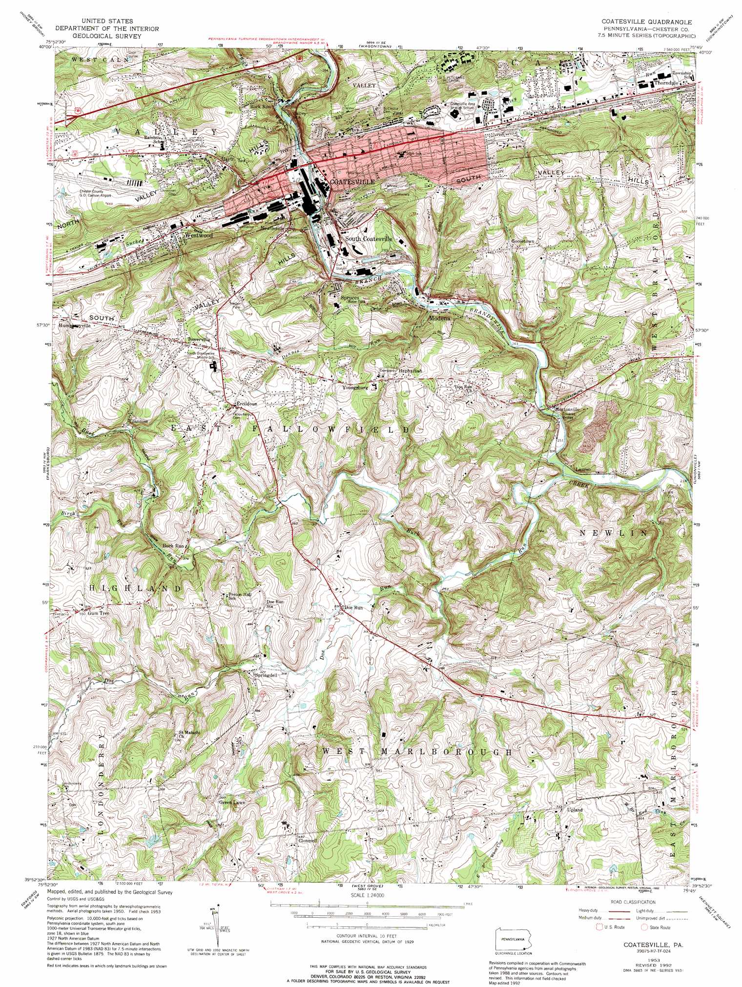
Coatesville Topo Map Pennsylvania
To zoom in, hover over the map of Coatesville
USGS Topo Quad 39075h7 - 1:24,000 scale
| Topo Map Name: | Coatesville |
| USGS Topo Quad ID: | 39075h7 |
| Print Size: | ca. 21 1/4" wide x 27" high |
| Southeast Coordinates: | 39.875° N latitude / 75.75° W longitude |
| Map Center Coordinates: | 39.9375° N latitude / 75.8125° W longitude |
| U.S. State: | PA |
| Filename: | o39075h7.jpg |
| Download Map JPG Image: | Coatesville topo map 1:24,000 scale |
| Map Type: | Topographic |
| Topo Series: | 7.5´ |
| Map Scale: | 1:24,000 |
| Source of Map Images: | United States Geological Survey (USGS) |
| Alternate Map Versions: |
Coatesville PA 1953, updated 1956 Download PDF Buy paper map Coatesville PA 1953, updated 1965 Download PDF Buy paper map Coatesville PA 1953, updated 1969 Download PDF Buy paper map Coatesville PA 1953, updated 1974 Download PDF Buy paper map Coatesville PA 1953, updated 1975 Download PDF Buy paper map Coatesville PA 1953, updated 1992 Download PDF Buy paper map Coatesville PA 1997, updated 1999 Download PDF Buy paper map Coatesville PA 2010 Download PDF Buy paper map Coatesville PA 2013 Download PDF Buy paper map Coatesville PA 2016 Download PDF Buy paper map |
1:24,000 Topo Quads surrounding Coatesville
Terre Hill |
Morgantown |
Elverson |
Pottstown |
Phoenixville |
New Holland |
Honey Brook |
Wagontown |
Downingtown |
Malvern |
Gap |
Parkesburg |
Coatesville |
Unionville |
West Chester |
Kirkwood |
Oxford |
West Grove |
Kennett Square |
Wilmington North |
Rising Sun |
Bay View |
Newark West |
Newark East |
Wilmington South |
> Back to 39075e1 at 1:100,000 scale
> Back to 39074a1 at 1:250,000 scale
> Back to U.S. Topo Maps home
Coatesville topo map: Gazetteer
Coatesville: Airports
Caln Township Heliport elevation 150m 492′Chester County/G O Carlson Airport elevation 197m 646′
Stoltzfus Airport (historical) elevation 192m 629′
Coatesville: Bridges
Speakman Number 1 Covered Bridge elevation 78m 255′Speakman Number 2 Covered Bridge elevation 93m 305′
Coatesville: Dams
Beaver Dam elevation 113m 370′Buck Run Dam elevation 108m 354′
Kurtz Dam elevation 105m 344′
Rock Run Dam elevation 91m 298′
Rockby Dam elevation 93m 305′
Coatesville: Populated Places
Buck Run elevation 114m 374′Caln elevation 100m 328′
Clonmell elevation 144m 472′
Coatesville elevation 97m 318′
Doe Run elevation 92m 301′
Ercildoun elevation 168m 551′
Glenrose elevation 121m 396′
Goosetown elevation 143m 469′
Green Lawn elevation 123m 403′
Hayti elevation 152m 498′
Hephzibah elevation 157m 515′
Laurel elevation 80m 262′
Modena elevation 94m 308′
Mortonville elevation 76m 249′
Newlinville elevation 110m 360′
South Coatesville elevation 114m 374′
Springdell elevation 103m 337′
Spruces elevation 129m 423′
Towerville elevation 169m 554′
Upland elevation 162m 531′
Westwood elevation 110m 360′
Youngsburg elevation 153m 501′
Coatesville: Post Offices
Derrydown Post Office (historical) elevation 114m 374′Leonard Post Office (historical) elevation 164m 538′
Coatesville: Reservoirs
Lake Kurtz elevation 105m 344′Coatesville: Streams
Birch Run elevation 109m 357′Buck Run elevation 69m 226′
Dennis Run elevation 83m 272′
Doe Run elevation 79m 259′
Rock Run elevation 99m 324′
Sucker Run elevation 94m 308′
Coatesville digital topo map on disk
Buy this Coatesville topo map showing relief, roads, GPS coordinates and other geographical features, as a high-resolution digital map file on DVD:
Atlantic Coast (NY, NJ, PA, DE, MD, VA, NC)
Buy digital topo maps: Atlantic Coast (NY, NJ, PA, DE, MD, VA, NC)
 map DVD")