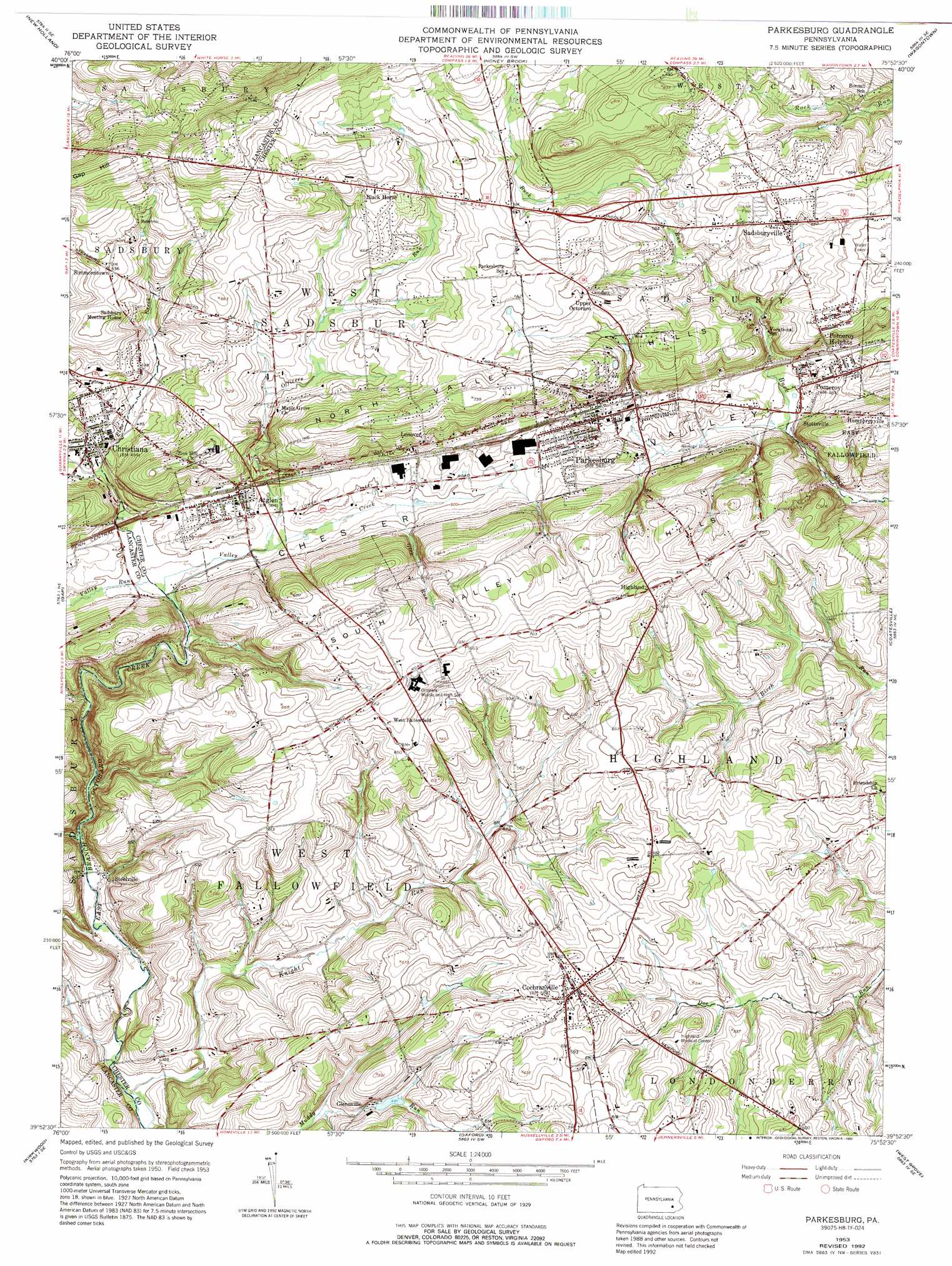
Parkesburg Topo Map Pennsylvania
To zoom in, hover over the map of Parkesburg
USGS Topo Quad 39075h8 - 1:24,000 scale
| Topo Map Name: | Parkesburg |
| USGS Topo Quad ID: | 39075h8 |
| Print Size: | ca. 21 1/4" wide x 27" high |
| Southeast Coordinates: | 39.875° N latitude / 75.875° W longitude |
| Map Center Coordinates: | 39.9375° N latitude / 75.9375° W longitude |
| U.S. State: | PA |
| Filename: | o39075h8.jpg |
| Download Map JPG Image: | Parkesburg topo map 1:24,000 scale |
| Map Type: | Topographic |
| Topo Series: | 7.5´ |
| Map Scale: | 1:24,000 |
| Source of Map Images: | United States Geological Survey (USGS) |
| Alternate Map Versions: |
Parkesburg PA 1953, updated 1955 Download PDF Buy paper map Parkesburg PA 1953, updated 1967 Download PDF Buy paper map Parkesburg PA 1953, updated 1969 Download PDF Buy paper map Parkesburg PA 1953, updated 1975 Download PDF Buy paper map Parkesburg PA 1953, updated 1992 Download PDF Buy paper map Parkesburg PA 2010 Download PDF Buy paper map Parkesburg PA 2013 Download PDF Buy paper map Parkesburg PA 2016 Download PDF Buy paper map |
1:24,000 Topo Quads surrounding Parkesburg
Ephrata |
Terre Hill |
Morgantown |
Elverson |
Pottstown |
Leola |
New Holland |
Honey Brook |
Wagontown |
Downingtown |
Quarryville |
Gap |
Parkesburg |
Coatesville |
Unionville |
Wakefield |
Kirkwood |
Oxford |
West Grove |
Kennett Square |
Conowingo Dam |
Rising Sun |
Bay View |
Newark West |
Newark East |
> Back to 39075e1 at 1:100,000 scale
> Back to 39074a1 at 1:250,000 scale
> Back to U.S. Topo Maps home
Parkesburg topo map: Gazetteer
Parkesburg: Dams
Parkesburg Iron Company Dam elevation 171m 561′Parkesburg: Populated Places
Atglen elevation 149m 488′Black Horse elevation 212m 695′
Christiana elevation 145m 475′
Cochranville elevation 177m 580′
Glennville elevation 147m 482′
Humphreyville elevation 186m 610′
Lenover elevation 176m 577′
Parkesburg elevation 160m 524′
Pomeroy elevation 141m 462′
Pomeroy Heights elevation 196m 643′
Sadsbury Meeting House elevation 183m 600′
Sadsburyville elevation 195m 639′
Simmonstown elevation 193m 633′
Steelville elevation 119m 390′
Stottsville elevation 138m 452′
Upper Octoraro elevation 197m 646′
Parkesburg: Post Offices
Black Horse Post Office (historical) elevation 212m 695′Christiana Post Office (historical) elevation 145m 475′
Parkesburg: Streams
Annan Run elevation 112m 367′Glen Run elevation 146m 479′
Knight Run elevation 103m 337′
Knott Run elevation 116m 380′
Officers Run elevation 137m 449′
Pine Creek elevation 139m 456′
Valley Creek elevation 133m 436′
Valley Run elevation 132m 433′
Parkesburg digital topo map on disk
Buy this Parkesburg topo map showing relief, roads, GPS coordinates and other geographical features, as a high-resolution digital map file on DVD:
Atlantic Coast (NY, NJ, PA, DE, MD, VA, NC)
Buy digital topo maps: Atlantic Coast (NY, NJ, PA, DE, MD, VA, NC)
 map DVD")