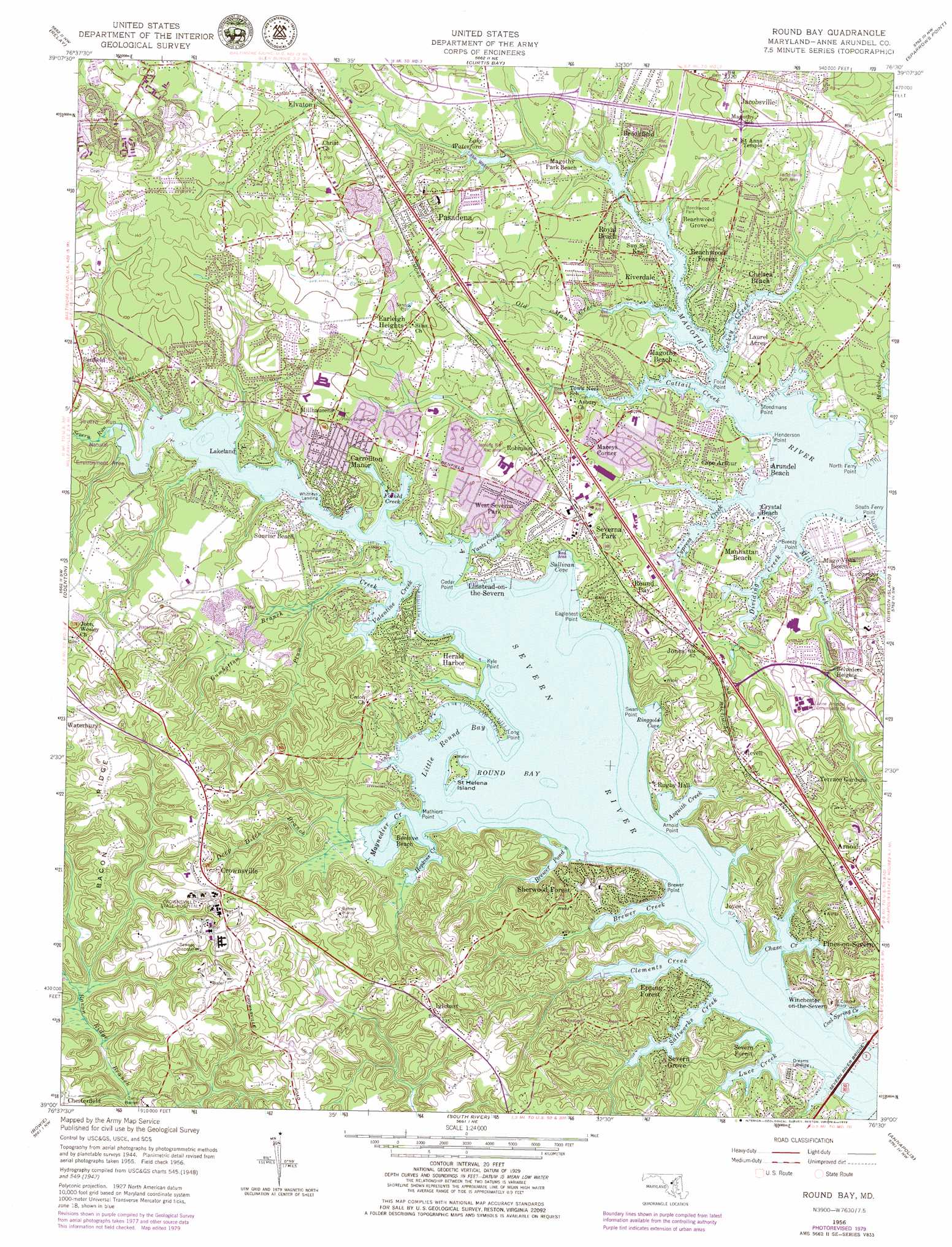
Round Bay Topo Map Maryland
To zoom in, hover over the map of Round Bay
USGS Topo Quad 39076a5 - 1:24,000 scale
| Topo Map Name: | Round Bay |
| USGS Topo Quad ID: | 39076a5 |
| Print Size: | ca. 21 1/4" wide x 27" high |
| Southeast Coordinates: | 39° N latitude / 76.5° W longitude |
| Map Center Coordinates: | 39.0625° N latitude / 76.5625° W longitude |
| U.S. State: | MD |
| Filename: | o39076a5.jpg |
| Download Map JPG Image: | Round Bay topo map 1:24,000 scale |
| Map Type: | Topographic |
| Topo Series: | 7.5´ |
| Map Scale: | 1:24,000 |
| Source of Map Images: | United States Geological Survey (USGS) |
| Alternate Map Versions: |
Round Bay MD 1949, updated 1953 Download PDF Buy paper map Round Bay MD 1949, updated 1953 Download PDF Buy paper map Round Bay MD 1956, updated 1960 Download PDF Buy paper map Round Bay MD 1956, updated 1966 Download PDF Buy paper map Round Bay MD 1956, updated 1972 Download PDF Buy paper map Round Bay MD 1956, updated 1979 Download PDF Buy paper map Round Bay MD 2011 Download PDF Buy paper map Round Bay MD 2014 Download PDF Buy paper map Round Bay MD 2016 Download PDF Buy paper map |
1:24,000 Topo Quads surrounding Round Bay
Ellicott City |
Baltimore West |
Baltimore East |
Middle River |
Gunpowder Neck |
Savage |
Relay |
Curtis Bay |
Sparrows Point |
Swan Point |
Laurel |
Odenton |
Round Bay |
Gibson Island |
Love Point |
Lanham |
Bowie |
South River |
Annapolis |
Kent Island |
Upper Marlboro |
Bristol |
Deale |
Claiborne |
> Back to 39076a1 at 1:100,000 scale
> Back to 39076a1 at 1:250,000 scale
> Back to U.S. Topo Maps home
Round Bay topo map: Gazetteer
Round Bay: Airports
Clements Creek Seaplane Base elevation 0m 0′Round Bay: Bays
Asquith Creek elevation 0m 0′Brewer Creek elevation 0m 0′
Brewer Pond elevation 8m 26′
Browns Cove elevation 4m 13′
Browns Cove elevation 4m 13′
Buckinghams Cove elevation 10m 32′
Cattail Creek elevation 0m 0′
Chase Creek elevation 0m 0′
Clements Creek elevation 0m 0′
Cockey Creek elevation 0m 0′
Cold Spring Cove elevation 0m 0′
Cool Spring Cove elevation 0m 0′
Cove of Cork elevation 2m 6′
Crystal Cove elevation 0m 0′
Cypress Creek elevation 1m 3′
Dividing Creek elevation 0m 0′
Forked Creek elevation 2m 6′
Hopkins Creek elevation 0m 0′
Indian Creek elevation 5m 16′
Little Round Bay elevation 0m 0′
Luce Creek elevation 0m 0′
Marriott Cove elevation 0m 0′
Martins Pond elevation 0m 0′
Maynadier Creek elevation 7m 22′
North Cypress Creek elevation 6m 19′
North Fork Chase Creek elevation 0m 0′
Rays Pond elevation 8m 26′
Ringgold Cove elevation 0m 0′
Robinson Cove elevation 4m 13′
Rock Cove elevation 3m 9′
Ross Cove elevation 4m 13′
Round Bay elevation 0m 0′
Saltworks Creek elevation 0m 0′
Stevens Creek elevation 4m 13′
Sullivan Cove elevation 1m 3′
Swan Cove elevation 0m 0′
Tar Hill Cove elevation 4m 13′
Valentine Creek elevation 0m 0′
Winchester Arm elevation 12m 39′
Yantz Creek elevation 0m 0′
Round Bay: Bridges
Severn River Bridge elevation 0m 0′Round Bay: Capes
Arnold Point elevation 7m 22′Boundary Stone Point elevation 3m 9′
Breezy Point elevation 0m 0′
Brewer Point elevation 1m 3′
Brooksbys Point elevation 0m 0′
Cedar Point elevation 1m 3′
Cocks Point elevation 0m 0′
Eaglenest Point elevation 10m 32′
Focal Point elevation 0m 0′
Henderson Point elevation 1m 3′
Kyle Point elevation 2m 6′
Long Point elevation 3m 9′
Mathews Point elevation 0m 0′
Mathiers Point elevation 16m 52′
North Ferry Point elevation 7m 22′
Pea Patch Point elevation 0m 0′
Point Lookout elevation 8m 26′
South Ferry Point elevation 2m 6′
Steedmans Point elevation 3m 9′
Stony Point elevation 1m 3′
Swan Point elevation 16m 52′
Round Bay: Channels
The Narrows elevation 0m 0′Round Bay: Cliffs
Wiona Cliffs elevation 12m 39′Round Bay: Crossings
Interchange 5 elevation 42m 137′Round Bay: Dams
Lake Waterford Dam elevation 8m 26′Saefern Recreation Lake Dam elevation 11m 36′
Round Bay: Harbors
Ferry Point Yacht Club elevation -2m -7′Round Bay: Islands
Saint Helena Island elevation 10m 32′Round Bay: Lakes
Arden Pond elevation 2m 6′Bunks Pond elevation 30m 98′
Cattail Pond elevation 23m 75′
Cedar Pond elevation 2m 6′
Duck Pond elevation 30m 98′
Elizabeth Pond elevation 12m 39′
Fox Pond elevation 5m 16′
Hartings Ponds elevation 10m 32′
Hidden Pond elevation 5m 16′
Hidden Pond elevation 31m 101′
Lake Liberty elevation 1m 3′
Sacketts Pond elevation 2m 6′
Timberneck Pond elevation 6m 19′
Winterberry Pond elevation 9m 29′
Round Bay: Parks
Arden Park elevation 23m 75′Bacon Ridge Natural Area elevation 27m 88′
Beechwood Park elevation 11m 36′
Belvedere Park elevation 24m 78′
Brown Baseball Field elevation 21m 68′
Cypress Creek Park elevation 11m 36′
Elvaton Park elevation 36m 118′
Generals Highway Corridor Park elevation 30m 98′
Herald Harbor Park elevation 17m 55′
Jacobsville Recreation Area elevation 25m 82′
Jenning Road Recreation Area elevation 14m 45′
Kinder Farm Park elevation 25m 82′
Lake Shore Athletic Complex elevation 20m 65′
Lake Waterford Park elevation 12m 39′
Magovista Park elevation 6m 19′
Olson Memorial Pool elevation 25m 82′
Siegert Field elevation 20m 65′
Southgate Old Mill Park elevation 28m 91′
Sullivans Cove Natural Area elevation 5m 16′
Twin Oaks Park elevation 14m 45′
Waterbury Recreation Area elevation 35m 114′
Round Bay: Populated Places
Allenville elevation 12m 39′Arden on the Severn elevation 14m 45′
Arnold elevation 41m 134′
Arundel Beach elevation 5m 16′
Asberry (historical) elevation 39m 127′
Ashcroft elevation 38m 124′
Bancroft elevation 25m 82′
Barrington Manor elevation 16m 52′
Beachwood Forest elevation 13m 42′
Beachwood Grove elevation 12m 39′
Belleview Estates elevation 26m 85′
Belvedere Heights elevation 26m 85′
Belvoir Farms elevation 44m 144′
Belvoir Manor elevation 57m 187′
Ben Oaks elevation 18m 59′
Bendale elevation 28m 91′
Benfield elevation 38m 124′
Berrywood elevation 6m 19′
Berrywood West elevation 6m 19′
Birchwood elevation 11m 36′
Bluff Point elevation 19m 62′
Briar Cliff on the Severn elevation 39m 127′
Brightview Woods elevation 49m 160′
Brightwood elevation 49m 160′
Brightwood Terrace elevation 35m 114′
Brookfield elevation 18m 59′
Brookfield on the Magothy elevation 12m 39′
Campus Green elevation 15m 49′
Candlewood elevation 32m 104′
Cape Arthur elevation 4m 13′
Cape McKinsey elevation 6m 19′
Cape Sable elevation 8m 26′
Capri Estates elevation 4m 13′
Captains Cove elevation 20m 65′
Carriage Hills elevation 40m 131′
Carrollton Manor elevation 24m 78′
Chartridge elevation 17m 55′
Chartwell elevation 30m 98′
Chartwood elevation 30m 98′
Chatham Hills elevation 17m 55′
Chelsea Beach elevation 20m 65′
Chelsea Pines elevation 20m 65′
Chesterfield elevation 39m 127′
Clearview Village elevation 18m 59′
Clumber elevation 20m 65′
Colchester on the Severn elevation 16m 52′
College Hills elevation 19m 62′
College Manor elevation 20m 65′
College Station elevation 13m 42′
Cool Pond elevation 12m 39′
Cranberry Woods elevation 46m 150′
Cresston Park elevation 9m 29′
Crownsville elevation 38m 124′
Crystal Beach elevation 2m 6′
Cypress Creek elevation 5m 16′
Deerfield elevation 23m 75′
Dellwood elevation 30m 98′
Divinity Cove elevation 11m 36′
Dogwood Trailer Park elevation 27m 88′
Downs on the Severn elevation 23m 75′
Dreams Landing elevation 10m 32′
Drexel Estates elevation 43m 141′
Duffield elevation 24m 78′
Dunkeld Manor elevation 9m 29′
Dunstable Green elevation 29m 95′
Earleigh Heights elevation 34m 111′
Edinboro Estates elevation 32m 104′
Elvaton elevation 19m 62′
Elvaton Acres elevation 37m 121′
Epping Farms elevation 31m 101′
Epping Forest elevation 22m 72′
Epping Forest Manor elevation 40m 131′
Evans Hill elevation 23m 75′
Evergreen Estates elevation 15m 49′
Fair Winds elevation 24m 78′
Fairoaks elevation 8m 26′
Farish Farms elevation 48m 157′
Fernbrook elevation 13m 42′
Foxhollow elevation 29m 95′
Frost elevation 23m 75′
Glen Oban elevation 30m 98′
Gotts elevation 44m 144′
Hampton Manor elevation 43m 141′
Harbor Oaks elevation 39m 127′
Harbour Glen elevation 42m 137′
Harting Estates elevation 15m 49′
Herald Harbor elevation 15m 49′
Hickory Hills elevation 32m 104′
Hidden Hills elevation 29m 95′
Hillendale elevation 28m 91′
Holly Point elevation 12m 39′
Hollywood elevation 21m 68′
Honeysuckle Ridge elevation 35m 114′
Iglehart elevation 42m 137′
Indian Creek Estates elevation 29m 95′
Indian Landing Estates elevation 26m 85′
Indian Village elevation 10m 32′
Jacobsville elevation 31m 101′
Jennings elevation 26m 85′
Jones elevation 18m 59′
Joyce elevation 22m 72′
Joyce Acres elevation 28m 91′
Kalmia Ridge elevation 7m 22′
Kensington elevation 19m 62′
Kilmarnock elevation 41m 134′
Lake Forest elevation 14m 45′
Lakeland elevation 15m 49′
Lakewood elevation 10m 32′
Lark Hill elevation 34m 111′
Laurel Acres elevation 12m 39′
Lindamoor on the Severn elevation 13m 42′
Linstead-on-the-Severn elevation 9m 29′
Little John elevation 24m 78′
Longmeadow elevation 9m 29′
Longmeadow North elevation 9m 29′
Lourds Manor elevation 12m 39′
Luce Creek elevation 11m 36′
Maceys Corner elevation 17m 55′
Mago Vista Beach elevation 6m 19′
Magothy Beach elevation 8m 26′
Magothy Estates elevation 9m 29′
Magothy Forest elevation 10m 32′
Magothy Forge elevation 11m 36′
Maid Marion elevation 27m 88′
Manhattan Beach elevation 6m 19′
Manhattan Manor elevation 10m 32′
Marabrooke elevation 34m 111′
Maynadier elevation 24m 78′
McKinsey Park elevation 7m 22′
Millhausens elevation 25m 82′
Moorings on the Magothy elevation 1m 3′
North Cape Arthur elevation 12m 39′
Norwich Acres elevation 5m 16′
Nottingham elevation 36m 118′
Oak Grove elevation 8m 26′
Oak Hollow elevation 15m 49′
Oak Landing elevation 6m 19′
Oakhill elevation 17m 55′
Oakleigh Forest elevation 12m 39′
Oaks of Severna Park elevation 27m 88′
Old County Estates elevation 34m 111′
Old Mill elevation 30m 98′
Old Severna Park elevation 13m 42′
Omar (historical) elevation 23m 75′
Pack Town elevation 18m 59′
Palisades on the Severn elevation 6m 19′
Palisades Park elevation 15m 49′
Parkview elevation 21m 68′
Pasadena elevation 25m 82′
Pasadena Manor elevation 20m 65′
Pine Bluff elevation 42m 137′
Pine Crest elevation 23m 75′
Pines-on-Severn elevation 34m 111′
Pohlman Point elevation 3m 9′
Point Field Landing on the Severn elevation 24m 78′
Point Somerset elevation 14m 45′
Quail Run elevation 33m 108′
Raintree elevation 18m 59′
Ravenshead elevation 36m 118′
Revell elevation 34m 111′
Rivendell elevation 19m 62′
Riverdale elevation 9m 29′
Riverdale Forest elevation 13m 42′
Robin Hood Hill elevation 19m 62′
Robinson elevation 15m 49′
Rolling Hills elevation 38m 124′
Ross Cove elevation 12m 39′
Round Bay elevation 17m 55′
Round Bay View elevation 9m 29′
Royal Beach elevation 12m 39′
Rubert Manor elevation 33m 108′
Rugby Hall elevation 18m 59′
Rugby Hall Estates elevation 32m 104′
Sabrina Park elevation 31m 101′
Saefern elevation 36m 118′
Saltworks on the Severn elevation 39m 127′
Seaborne Estates elevation 20m 65′
Selby Grove elevation 21m 68′
Severn Forest elevation 17m 55′
Severn Grove elevation 24m 78′
Severn Heights elevation 30m 98′
Severn Landing elevation 25m 82′
Severna Forest elevation 22m 72′
Severna Gardens elevation 18m 59′
Severna Park elevation 12m 39′
Severndale elevation 23m 75′
Severnview elevation 21m 68′
Sherwood Forest elevation 31m 101′
Shipleys Choice elevation 38m 124′
Smugglers Cove elevation 7m 22′
Spring Fields elevation 47m 154′
Stewarts Landing elevation 18m 59′
Stewarts Purchase elevation 31m 101′
Summer Hill Trailer Park elevation 34m 111′
Summerhill Park elevation 35m 114′
Sun Set Knoll elevation 7m 22′
Sunrise Beach elevation 21m 68′
Swan Point Estates elevation 30m 98′
Tall Timbers elevation 47m 154′
Tebbston elevation 8m 26′
Terrace Gardens elevation 40m 131′
The Dales elevation 34m 111′
The Downs elevation 31m 101′
The Timbers elevation 29m 95′
The Village elevation 22m 72′
The Woods elevation 48m 157′
Trinity Farms elevation 12m 39′
Twin Harbors elevation 14m 45′
Valentine Creek elevation 30m 98′
Waterbury Heights elevation 28m 91′
Watson Place elevation 32m 104′
West Magothy Manor elevation 5m 16′
West Severna Park elevation 15m 49′
Wexford elevation 19m 62′
Whippoorwill Estates elevation 8m 26′
Whitehurst elevation 6m 19′
Whitneys Landing elevation 1m 3′
Willowbrook elevation 16m 52′
Winchester-on-the-Severn elevation 1m 3′
Windrush Farm elevation 11m 36′
Windy Knolls elevation 48m 157′
Woodlore elevation 36m 118′
Woytych elevation 41m 134′
Zeman elevation 41m 134′
Round Bay: Post Offices
Arnold Post Office elevation 36m 118′Crownsville Post Office elevation 44m 144′
Pasadena Post Office elevation 25m 82′
Robinson Post Office (historical) elevation 15m 49′
Severna Park Post Office elevation 18m 59′
Sherwood Forest Post Office elevation 26m 85′
Round Bay: Reservoirs
Foster Pond elevation 7m 22′Lake Waterford elevation 8m 26′
Saefern Lake elevation 11m 36′
Round Bay: Ridges
Bacon Ridge elevation 51m 167′Round Bay: Streams
Arthurs Run elevation 1m 3′Bailys Branch elevation -1m -4′
Beachwood Branch elevation 1m 3′
Bear Branch elevation 0m 0′
Brookfield Branch elevation 1m 3′
Cabin Branch elevation 2m 6′
Cedar Creek elevation 4m 13′
Chartwell Branch elevation 1m 3′
Cold Spring Branch elevation 0m 0′
Cypress Branch elevation 1m 3′
Davids Run elevation 0m 0′
Deep Ditch Branch elevation 1m 3′
Gumbottom Branch elevation 3m 9′
Hockley Branch elevation 0m 0′
Howard Creek elevation -1m -4′
Howards Branch elevation 4m 13′
Indian Creek Branch elevation 1m 3′
Indian Village Branch elevation 1m 3′
Kinder Branch elevation 11m 36′
Magothy Branch elevation 8m 26′
Mill Creek elevation 0m 0′
Muddy Run elevation 2m 6′
Nannys Branch elevation 1m 3′
Nannys Creek elevation 2m 6′
North Cypress Branch elevation 2m 6′
Old Man Creek elevation 5m 16′
Old Place Creek elevation 1m 3′
Plum Creek elevation 0m 0′
Pointfield Branch elevation 1m 3′
Rouses Branch elevation 13m 42′
Rowles Branch elevation 0m 0′
Severn Run elevation 0m 0′
Sewell Spring Branch elevation 1m 3′
Weems Creek elevation 0m 0′
Wolf Pit Branch elevation 3m 9′
Round Bay: Summits
Mount Misery elevation 43m 141′Round Bay: Swamps
Cockeys Creek Bog elevation 9m 29′Cypress Creek Bog elevation 1m 3′
Cypress Creek Savannah Bog elevation 2m 6′
Deep Ditch Bog elevation 1m 3′
Dill Road Bog elevation 1m 3′
Gumbottom Bog elevation 3m 9′
Sullivans Cove Bog elevation 2m 6′
Round Bay digital topo map on disk
Buy this Round Bay topo map showing relief, roads, GPS coordinates and other geographical features, as a high-resolution digital map file on DVD:
Atlantic Coast (NY, NJ, PA, DE, MD, VA, NC)
Buy digital topo maps: Atlantic Coast (NY, NJ, PA, DE, MD, VA, NC)
 map DVD")