Sparrows Point Topo Map Maryland
To zoom in, hover over the map of Sparrows Point
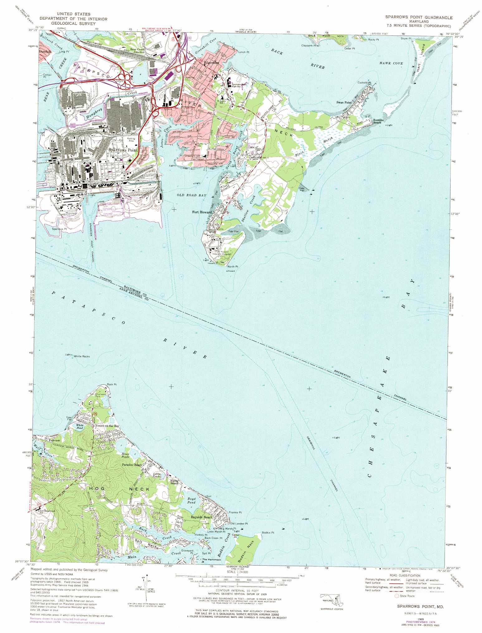
USGS Topo Quad 39076b4 - 1:24,000 scale
| Topo Map Name: | Sparrows Point |
| USGS Topo Quad ID: | 39076b4 |
| Print Size: | ca. 21 1/4" wide x 27" high |
| Southeast Coordinates: | 39.125° N latitude / 76.375° W longitude |
| Map Center Coordinates: | 39.1875° N latitude / 76.4375° W longitude |
| U.S. State: | MD |
| Filename: | o39076b4.jpg |
| Download Map JPG Image: | Sparrows Point topo map 1:24,000 scale |
| Map Type: | Topographic |
| Topo Series: | 7.5´ |
| Map Scale: | 1:24,000 |
| Source of Map Images: | United States Geological Survey (USGS) |
| Alternate Map Versions: |
Sparrows Point MD 1944, updated 1960 Download PDF Buy paper map Sparrows Point MD 1944, updated 1962 Download PDF Buy paper map Sparrows Point MD 1969, updated 1971 Download PDF Buy paper map Sparrows Point MD 1969, updated 1975 Download PDF Buy paper map Sparrows Point MD 1969, updated 1975 Download PDF Buy paper map Sparrows Point MD 2011 Download PDF Buy paper map Sparrows Point MD 2014 Download PDF Buy paper map Sparrows Point MD 2016 Download PDF Buy paper map |
1:24,000 Topo Quads surrounding Sparrows Point
Cockeysville |
Towson |
White Marsh |
Edgewood |
Perryman |
Baltimore West |
Baltimore East |
Middle River |
Gunpowder Neck |
Hanesville |
Relay |
Curtis Bay |
Sparrows Point |
Swan Point |
Rock Hall |
Odenton |
Round Bay |
Gibson Island |
Love Point |
Langford Creek |
Bowie |
South River |
Annapolis |
Kent Island |
Queenstown |
> Back to 39076a1 at 1:100,000 scale
> Back to 39076a1 at 1:250,000 scale
> Back to U.S. Topo Maps home
Sparrows Point topo map: Gazetteer
Sparrows Point: Bars
Bodkin Point Shoal elevation 0m 0′North Shoal elevation 0m 0′
Rock Point Shoal elevation 0m 0′
Sevenfoot Knoll elevation 0m 0′
Sixfoot Knoll elevation 0m 0′
Sparrows Point: Bays
Back Creek elevation 0m 0′Bodkin Creek elevation 0m 0′
First Cove elevation 0m 0′
Greenhill Cove elevation 0m 0′
Main Creek elevation 0m 0′
Old House Cove elevation 0m 0′
Old Road Bay elevation 0m 0′
Perry Cove elevation 0m 0′
Sams Cove elevation 0m 0′
Second Cove elevation 7m 22′
Shallow Creek elevation 0m 0′
Wall Cove elevation 0m 0′
Sparrows Point: Capes
Back Creek Point elevation 4m 13′Big Marsh Point elevation 1m 3′
Bodkin Neck elevation 6m 19′
Bodkin Point elevation 0m 0′
Cattail Point elevation 0m 0′
Cedar Point elevation 3m 9′
Cedar Point elevation 0m 0′
Claphams Point elevation 0m 0′
Claybank Point elevation 0m 0′
Cuckold Point elevation 0m 0′
Drum Point elevation 0m 0′
Frankie Point elevation 1m 3′
Graveyard Point elevation 2m 6′
Hickory Point elevation 2m 6′
Hog Neck elevation 20m 65′
Little Marsh Point elevation 1m 3′
Lloyd Point elevation 2m 6′
Long Point elevation 0m 0′
Lynch Point elevation 0m 0′
North Point elevation 1m 3′
Old Landen Point elevation 3m 9′
Patapsco River Neck elevation 6m 19′
Rock Point elevation 2m 6′
Rocky Point elevation 1m 3′
Sedgy Point elevation 0m 0′
Sparrows Point elevation 1m 3′
Spit Neck elevation 4m 13′
Spit Point elevation 3m 9′
Tom Point elevation 3m 9′
Sparrows Point: Channels
Brewerton Channel elevation 0m 0′Craighill Angle elevation 0m 0′
Cutoff Channel elevation 0m 0′
Penwood Channel elevation 0m 0′
Sparrows Point Channel elevation 0m 0′
Sparrows Point: Islands
Hathaway Island (historical) elevation 4m 13′Pleasure Island elevation 1m 3′
The Hammock elevation 2m 6′
White Rocks elevation 0m 0′
Sparrows Point: Lakes
Boyd Pond elevation 0m 0′Hines Ponds elevation 0m 0′
Letha Ponds elevation 3m 9′
White Pond elevation 0m 0′
Yates Pond elevation 1m 3′
Sparrows Point: Parks
Fort Howard Park elevation 1m 3′Fort Smallwood Park elevation 2m 6′
Hancocks Resolution Park elevation 3m 9′
Shallow Creek Park elevation 3m 9′
Sparrows Point: Populated Places
Alloway elevation 15m 49′Bay Shore Park (historical) elevation 3m 9′
Bayshore (historical) elevation 1m 3′
Bayside Beach elevation 3m 9′
Baywood Mobile Home Park elevation 3m 9′
Bear Creek Junction elevation 5m 16′
Belhaven Beach elevation 11m 36′
Belhaven Woods elevation 17m 55′
Bodkin Manor elevation 3m 9′
Chase Wood Run elevation 9m 29′
Chesapeake Terrace elevation 3m 9′
Darinton (historical) elevation 3m 9′
Edgemere elevation 6m 19′
Fairhaven Beach elevation 27m 88′
Fairview elevation 7m 22′
Fitzell elevation 5m 16′
Fitzell (historical) elevation 8m 26′
Fort Howard elevation 5m 16′
Hampton Chase elevation 21m 68′
Hickory Point elevation 2m 6′
Kurtz Beach elevation 3m 9′
Lincoln Mobile Home Park elevation 3m 9′
Lodge Forest elevation 6m 19′
Lynch Point elevation 1m 3′
Maryland Beach elevation 3m 9′
Paradise Beach elevation 4m 13′
Pasadena Beach elevation 1m 3′
Penwood Mobile Home Park elevation 4m 13′
Penwood Park (historical) elevation 1m 3′
Pine Crest North elevation 8m 26′
Pine Crest West elevation 28m 91′
Pinehurst Harbour elevation 1m 3′
Poplar Ridge elevation 3m 9′
Ramona Beach elevation 1m 3′
Rock Creek Park elevation 12m 39′
Rockwood Beach elevation 4m 13′
Sparrows Point elevation 3m 9′
Springdale elevation 11m 36′
Swan Point elevation 0m 0′
Venice on the Bay elevation 8m 26′
Water View elevation 4m 13′
Sparrows Point: Post Offices
Fort Howard Post Office elevation 5m 16′Sparrows Point Post Office elevation 5m 16′
Sparrows Point: Streams
Back River elevation 0m 0′Bullneck Creek elevation 0m 0′
Humphrey Creek elevation 1m 3′
Jones Creek elevation 0m 0′
North Point Creek elevation 0m 0′
Patapsco River elevation 0m 0′
Sparrows Point: Swamps
Black Marsh elevation 1m 3′Hines Pond Bog elevation 1m 3′
Sparrows Point digital topo map on disk
Buy this Sparrows Point topo map showing relief, roads, GPS coordinates and other geographical features, as a high-resolution digital map file on DVD:
Atlantic Coast (NY, NJ, PA, DE, MD, VA, NC)
Buy digital topo maps: Atlantic Coast (NY, NJ, PA, DE, MD, VA, NC)
 map DVD")