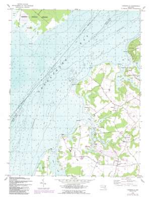
Hanesville Topo Map Maryland
To zoom in, hover over the map of Hanesville
USGS Topo Quad 39076c2 - 1:24,000 scale
| Topo Map Name: | Hanesville |
| USGS Topo Quad ID: | 39076c2 |
| Print Size: | ca. 21 1/4" wide x 27" high |
| Southeast Coordinates: | 39.25° N latitude / 76.125° W longitude |
| Map Center Coordinates: | 39.3125° N latitude / 76.1875° W longitude |
| U.S. State: | MD |
| Filename: | o39076c2.jpg |
| Download Map JPG Image: | Hanesville topo map 1:24,000 scale |
| Map Type: | Topographic |
| Topo Series: | 7.5´ |
| Map Scale: | 1:24,000 |
| Source of Map Images: | United States Geological Survey (USGS) |
| Alternate Map Versions: |
Hanesville MD 1948, updated 1985 Download PDF Buy paper map Hanesville MD 1948, updated 1991 Download PDF Buy paper map Hanesville MD 1969 Download PDF Buy paper map Hanesville MD 1977 Download PDF Buy paper map Hanesville MD 2011 Download PDF Buy paper map Hanesville MD 2014 Download PDF Buy paper map Hanesville MD 2016 Download PDF Buy paper map |
1:24,000 Topo Quads surrounding Hanesville
> Back to 39076a1 at 1:100,000 scale
> Back to 39076a1 at 1:250,000 scale
> Back to U.S. Topo Maps home
Hanesville topo map: Gazetteer
Hanesville: Airports
Russell Airport (historical) elevation 12m 39′Hanesville: Bays
Beacon Bay elevation 0m 0′Codjus Cove elevation 0m 0′
Still Pond elevation 0m 0′
Towner Cove elevation 0m 0′
Hanesville: Capes
Abbey Point elevation 0m 0′Bush Point elevation 0m 0′
Fairlee Neck elevation 12m 39′
Handys Point elevation 0m 0′
Kinnaird Point elevation 7m 22′
Meeks Point elevation 14m 45′
Plum Point elevation 1m 3′
Rocky Point elevation 1m 3′
Shell Point elevation 0m 0′
Stoops Point elevation 0m 0′
Worton Point elevation 5m 16′
Hanesville: Islands
Monks Island elevation 3m 9′Hanesville: Lakes
Big Fairlee Pond elevation 0m 0′Stavley Pond elevation 0m 0′
Hanesville: Populated Places
Buck Neck elevation 7m 22′Buck Neck Landing elevation 4m 13′
Chesapeake Landing elevation 12m 39′
Copeland elevation 9m 29′
Great Oak Estates elevation 7m 22′
Great Oak Landing elevation 0m 0′
Great Oak Manor elevation 0m 0′
Hanesville elevation 24m 78′
Kinnairds Point elevation 13m 42′
Melitota elevation 17m 55′
Millbrook elevation 7m 22′
Newtown elevation 12m 39′
Worton Heights elevation 11m 36′
Hanesville: Post Offices
Hanesville Post Office (historical) elevation 18m 59′Hanesville: Reservoirs
Millbrook Lake elevation 7m 22′Hanesville: Streams
Abbey Creek elevation 0m 0′Bush River elevation 0m 0′
Churn Creek elevation 0m 0′
Cod Creek elevation 0m 0′
Fairlee Creek elevation 0m 0′
Mill Creek elevation 0m 0′
Orchards Branch elevation 0m 0′
Still Pond Creek elevation 0m 0′
Tims Creek elevation 0m 0′
Worton Channel elevation 3m 9′
Worton Creek elevation 0m 0′
Hanesville digital topo map on disk
Buy this Hanesville topo map showing relief, roads, GPS coordinates and other geographical features, as a high-resolution digital map file on DVD:
Atlantic Coast (NY, NJ, PA, DE, MD, VA, NC)
Buy digital topo maps: Atlantic Coast (NY, NJ, PA, DE, MD, VA, NC)


