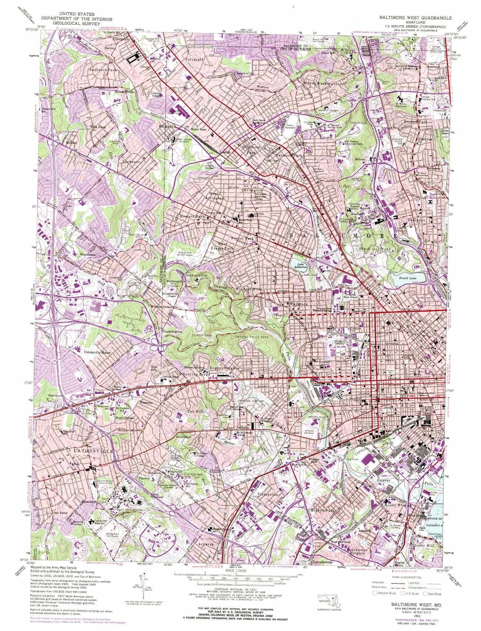
Baltimore West Topo Map Maryland
To zoom in, hover over the map of Baltimore West
USGS Topo Quad 39076c6 - 1:24,000 scale
| Topo Map Name: | Baltimore West |
| USGS Topo Quad ID: | 39076c6 |
| Print Size: | ca. 21 1/4" wide x 27" high |
| Southeast Coordinates: | 39.25° N latitude / 76.625° W longitude |
| Map Center Coordinates: | 39.3125° N latitude / 76.6875° W longitude |
| U.S. State: | MD |
| Filename: | o39076c6.jpg |
| Download Map JPG Image: | Baltimore West topo map 1:24,000 scale |
| Map Type: | Topographic |
| Topo Series: | 7.5´ |
| Map Scale: | 1:24,000 |
| Source of Map Images: | United States Geological Survey (USGS) |
| Alternate Map Versions: |
Baltimore West MD 1953 Download PDF Buy paper map Baltimore West MD 1953 Download PDF Buy paper map Baltimore West MD 1953, updated 1956 Download PDF Buy paper map Baltimore West MD 1953, updated 1956 Download PDF Buy paper map Baltimore West MD 1953, updated 1968 Download PDF Buy paper map Baltimore West MD 1953, updated 1975 Download PDF Buy paper map Baltimore West MD 2011 Download PDF Buy paper map Baltimore West MD 2014 Download PDF Buy paper map Baltimore West MD 2016 Download PDF Buy paper map |
1:24,000 Topo Quads surrounding Baltimore West
Westminister |
Hampstead |
Hereford |
Phoenix |
Jarrettsville |
Finksburg |
Reisterstown |
Cockeysville |
Towson |
White Marsh |
Sykesville |
Ellicott City |
Baltimore West |
Baltimore East |
Middle River |
Clarksville |
Savage |
Relay |
Curtis Bay |
Sparrows Point |
Beltsville |
Laurel |
Odenton |
Round Bay |
Gibson Island |
> Back to 39076a1 at 1:100,000 scale
> Back to 39076a1 at 1:250,000 scale
> Back to U.S. Topo Maps home
Baltimore West topo map: Gazetteer
Baltimore West: Airports
Maryland Institute for Emergency Medical Heliport elevation 17m 55′Baltimore West: Bays
Ridgleys Cove elevation 0m 0′Smith Cove elevation 0m 0′
Baltimore West: Bridges
Baltimore Fire Station 32 elevation 9m 29′Baltimore West: Crossings
Interchange 10 elevation 55m 180′Interchange 50 elevation 50m 164′
Interchange 51 elevation 30m 98′
Interchange 52 elevation 6m 19′
Interchange 7 elevation 43m 141′
Interchange 8 elevation 46m 150′
Interchange 9 elevation 69m 226′
Baltimore West: Dams
Clear Spring Water Reservoir Dam elevation 50m 164′Druid Hill Lake Dam elevation 41m 134′
Lake Ashburton Dam elevation 98m 321′
Pecks Branch Dam elevation 112m 367′
Baltimore West: Parks
Babe Ruth Field elevation 34m 111′Baltimore Zoo elevation 99m 324′
Barre Circle Historic District elevation 13m 42′
Bentalou Recreation Center elevation 43m 141′
Bolton Hill Historic District elevation 59m 193′
Carlins Park (historical) elevation 104m 341′
Carroll Park elevation 23m 75′
Cold Spring Park elevation 59m 193′
Cylburn Park elevation 129m 423′
Dead Run Park elevation 97m 318′
Dickeyville Historic District elevation 77m 252′
Druid Hill Park elevation 93m 305′
Druid Hill Park Historic District elevation 93m 305′
Easterwood Park elevation 72m 236′
Easterwood Recreation Center elevation 73m 239′
Edmondson Heights Park elevation 117m 383′
Eutaw-Madison Apartment House Historic District elevation 73m 239′
Franklin Square elevation 33m 108′
Franklin Square Historic District elevation 33m 108′
Gwynn Oak Park elevation 93m 305′
Gwynns Falls Park elevation 94m 308′
Gwynns Falls Recreation Center elevation 21m 68′
Hanlon Park elevation 94m 308′
Harlem Park elevation 43m 141′
Hilton Recreation Center elevation 56m 183′
Irvin Luckman Memorial Park elevation 121m 396′
Lafayette Square elevation 55m 180′
Leakin Park elevation 109m 357′
Liberty Recreation Center elevation 124m 406′
Lucille Park elevation 127m 416′
Maiden Choice Park elevation 47m 154′
Medfield Heights Park elevation 83m 272′
Medfield Heights Recreation Center elevation 80m 262′
Pall Mall Playground elevation 128m 419′
Powder Mill Park elevation 101m 331′
Powder Mill Run Park elevation 121m 396′
Queensbury Playground elevation 134m 439′
Roland Park Historic District elevation 104m 341′
Roosevelt Park elevation 69m 226′
Schenley Recreation Center elevation 99m 324′
Silver Creek Park elevation 119m 390′
Towanda Playground elevation 115m 377′
Towanda Recreation Center elevation 111m 364′
Traci Atkins Park elevation 24m 78′
Union Square elevation 30m 98′
Union Square-Hollins Market Historic District elevation 25m 82′
Uplands Park elevation 90m 295′
Villa Nova Park elevation 114m 374′
Weegworth Park elevation 24m 78′
West Hills Park elevation 103m 337′
Western Run Park elevation 102m 334′
Westview Recreation Area elevation 136m 446′
Wilkins Avenue Recreation Center elevation 31m 101′
Wyman Park elevation 44m 144′
Baltimore West: Populated Places
Academy Heights elevation 135m 442′Arbutus elevation 46m 150′
Arlington elevation 134m 439′
Asylum (historical) elevation 127m 416′
Beechfield elevation 61m 200′
Bloomsbury elevation 140m 459′
Brigadoon elevation 140m 459′
Brighton elevation 137m 449′
Calverton elevation 41m 134′
Calverton Heights elevation 55m 180′
Carroll elevation 49m 160′
Catonsville elevation 146m 479′
Catonsville Heights elevation 147m 482′
Catonsville Manor elevation 138m 452′
Charlestown elevation 98m 321′
Cherry Hill elevation 8m 26′
Cheswolde elevation 117m 383′
Claremont (historical) elevation 22m 72′
Cold Spring elevation 131m 429′
College Hills elevation 121m 396′
Colonial Park elevation 129m 423′
Colonial Village elevation 145m 475′
Cylburn (historical) elevation 55m 180′
Denmore Park elevation 129m 423′
Dickeyville elevation 78m 255′
Dixon Hill elevation 117m 383′
Dorchester Heights elevation 36m 118′
Edmondson Ridge elevation 142m 465′
Edmondson Village elevation 93m 305′
Euclid Heights elevation 137m 449′
Evergreen elevation 81m 265′
Fallstaff elevation 139m 456′
Featherbed elevation 130m 426′
Forest Park elevation 127m 416′
Franklintown elevation 93m 305′
Fulton elevation 52m 170′
Gilmor Homes elevation 60m 196′
Glenmore Park elevation 134m 439′
Gwynn Oak elevation 130m 426′
Hampden elevation 75m 246′
Harristown elevation 150m 492′
Haywood Heights elevation 124m 406′
Hillsdale Green elevation 102m 334′
Howard Park elevation 128m 419′
Howardsville elevation 141m 462′
Hunting Ridge elevation 120m 393′
Irvington elevation 68m 223′
Kenwood elevation 103m 337′
Knollview elevation 93m 305′
Lakeland elevation 23m 75′
Leahigh elevation 141m 462′
Lochearn elevation 126m 413′
Melvale elevation 49m 160′
Milford elevation 128m 419′
Minersville (historical) elevation 22m 72′
Mondawmin elevation 73m 239′
Morrell Park elevation 31m 101′
Mount Clare elevation 21m 68′
Mount DeSales elevation 144m 472′
Mount Hope elevation 134m 439′
Mount Royal elevation 49m 160′
Mount Washington elevation 102m 334′
Mount Winans elevation 21m 68′
North Bend elevation 83m 272′
Norwood Heights elevation 57m 187′
Oak Forest elevation 147m 482′
Oak Forest Park elevation 151m 495′
Oaklee Village elevation 56m 183′
Paradise elevation 110m 360′
Patapsco Woods elevation 127m 416′
Pickwick elevation 128m 419′
Pikesville elevation 155m 508′
Pimlico elevation 136m 446′
Powhatan elevation 104m 341′
Powhatan Hill elevation 123m 403′
Ralston elevation 147m 482′
Rognel Heights elevation 103m 337′
Roland Park elevation 111m 364′
Rolling Road Farms elevation 122m 400′
Roslyn elevation 129m 423′
Rutherford Green elevation 139m 456′
Spring Gardens elevation 12m 39′
Sudbrook Park elevation 146m 479′
Television Hill elevation 72m 236′
Ten Hills elevation 75m 246′
The Terraces elevation 90m 295′
Villa Nova elevation 121m 396′
Village of Cross Keys elevation 79m 259′
Violetville elevation 57m 187′
Wakefield elevation 115m 377′
Walbrook elevation 82m 269′
Walden Circle elevation 130m 426′
West Arlington elevation 130m 426′
West Baltimore elevation 26m 85′
West Edmondale elevation 150m 492′
West Forest Park elevation 117m 383′
West Glen elevation 120m 393′
West Hills elevation 129m 423′
Westowne elevation 143m 469′
Westport elevation 19m 62′
Westview Park elevation 134m 439′
Wetheredsville elevation 76m 249′
Wilhelm Park elevation 23m 75′
Williamsburg elevation 150m 492′
Willow Glen elevation 133m 436′
Windsor Hills elevation 93m 305′
Windsor Mill Manor elevation 136m 446′
Windsor Terrace elevation 107m 351′
Woodberry elevation 65m 213′
Woodlawn elevation 103m 337′
Woodmoor elevation 138m 452′
Baltimore West: Post Offices
Arlington Station Baltimore Post Office elevation 122m 400′Carroll Station Baltimore Post Office elevation 61m 200′
Catonsville Post Office elevation 154m 505′
Druid Station Baltimore Post Office elevation 53m 173′
Franklin Station Baltimore Post Office elevation 25m 82′
Gwynn Oak Branch Baltimore Post Office elevation 123m 403′
Hampden-Roland Park Station Baltimore Post Office elevation 74m 242′
Mount Washington Station Baltimore Post Office elevation 59m 193′
Walbrook Station Baltimore Post Office elevation 85m 278′
Baltimore West: Reservoirs
Ashburton Lake elevation 112m 367′Clear Spring Water Reservoir elevation 50m 164′
Druid Lake elevation 70m 229′
Lake Ashburton elevation 98m 321′
Silver Lake elevation 32m 104′
Wash Water Lake elevation 81m 265′
Baltimore West: Streams
Dead Run elevation 45m 147′Gwynns Falls elevation 0m 0′
Gwynns Run elevation 96m 314′
Maidens Choice Run elevation 11m 36′
Scotts Level Branch elevation 115m 377′
Stony Run elevation 36m 118′
Western Run elevation 61m 200′
Baltimore West digital topo map on disk
Buy this Baltimore West topo map showing relief, roads, GPS coordinates and other geographical features, as a high-resolution digital map file on DVD:
Atlantic Coast (NY, NJ, PA, DE, MD, VA, NC)
Buy digital topo maps: Atlantic Coast (NY, NJ, PA, DE, MD, VA, NC)
 map DVD")