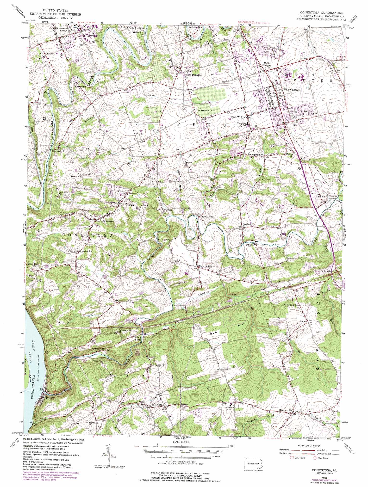
Conestoga Topo Map Pennsylvania
To zoom in, hover over the map of Conestoga
USGS Topo Quad 39076h3 - 1:24,000 scale
| Topo Map Name: | Conestoga |
| USGS Topo Quad ID: | 39076h3 |
| Print Size: | ca. 21 1/4" wide x 27" high |
| Southeast Coordinates: | 39.875° N latitude / 76.25° W longitude |
| Map Center Coordinates: | 39.9375° N latitude / 76.3125° W longitude |
| U.S. State: | PA |
| Filename: | o39076h3.jpg |
| Download Map JPG Image: | Conestoga topo map 1:24,000 scale |
| Map Type: | Topographic |
| Topo Series: | 7.5´ |
| Map Scale: | 1:24,000 |
| Source of Map Images: | United States Geological Survey (USGS) |
| Alternate Map Versions: |
Conestoga PA 1955, updated 1956 Download PDF Buy paper map Conestoga PA 1955, updated 1965 Download PDF Buy paper map Conestoga PA 1955, updated 1971 Download PDF Buy paper map Conestoga PA 1955, updated 1976 Download PDF Buy paper map Conestoga PA 1955, updated 1977 Download PDF Buy paper map Conestoga PA 1955, updated 1989 Download PDF Buy paper map Conestoga PA 1955, updated 1991 Download PDF Buy paper map Conestoga PA 2010 Download PDF Buy paper map Conestoga PA 2013 Download PDF Buy paper map Conestoga PA 2016 Download PDF Buy paper map |
1:24,000 Topo Quads surrounding Conestoga
Elizabethtown |
Manheim |
Lititz |
Ephrata |
Terre Hill |
Columbia West |
Columbia East |
Lancaster |
Leola |
New Holland |
Red Lion |
Safe Harbor |
Conestoga |
Quarryville |
Gap |
Stewartstown |
Airville |
Holtwood |
Wakefield |
Kirkwood |
Norrisville |
Fawn Grove |
Delta |
Conowingo Dam |
Rising Sun |
> Back to 39076e1 at 1:100,000 scale
> Back to 39076a1 at 1:250,000 scale
> Back to U.S. Topo Maps home
Conestoga topo map: Gazetteer
Conestoga: Parks
State Game Lands Number 288 elevation 149m 488′Conestoga: Populated Places
Baumgardner elevation 117m 383′Burnt Mills elevation 82m 269′
Colemanville elevation 66m 216′
Conestoga elevation 151m 495′
Herrville elevation 93m 305′
Martic Forge elevation 68m 223′
Marticville elevation 121m 396′
Millersville elevation 99m 324′
Mount Nebo elevation 214m 702′
New Danville elevation 123m 403′
Pequea elevation 52m 170′
Rawlinsville elevation 270m 885′
Rockhill elevation 75m 246′
Slackwater elevation 71m 232′
Smithville elevation 102m 334′
Stone Hill elevation 125m 410′
Union elevation 204m 669′
Wabank elevation 73m 239′
West Willow elevation 134m 439′
Willow Street elevation 147m 482′
Conestoga: Post Offices
Colemanville Post Office (historical) elevation 66m 216′Conestoga Post Office (historical) elevation 151m 495′
Marticville Post Office (historical) elevation 121m 396′
Millersville Post Office (historical) elevation 99m 324′
New Danville Post Office (historical) elevation 123m 403′
Petersville Post Office (historical) elevation 71m 232′
Rawlinsville Post Office (historical) elevation 270m 885′
Smithville Post Office (historical) elevation 102m 334′
Willow Street Post Office (historical) elevation 147m 482′
Conestoga: Springs
Big Spring elevation 104m 341′Conestoga: Streams
Big Beaver Creek elevation 89m 291′Climbers Run elevation 67m 219′
Goods Run elevation 79m 259′
Huber Run elevation 85m 278′
Indian Run elevation 60m 196′
Little Conestoga Creek elevation 59m 193′
Pequea Creek elevation 52m 170′
Silver Mine Run elevation 77m 252′
Stehman Run elevation 57m 187′
Trout Run elevation 101m 331′
Conestoga: Summits
Red Hill elevation 192m 629′Conestoga: Valleys
Grubb Hollow elevation 58m 190′Conestoga digital topo map on disk
Buy this Conestoga topo map showing relief, roads, GPS coordinates and other geographical features, as a high-resolution digital map file on DVD:
Atlantic Coast (NY, NJ, PA, DE, MD, VA, NC)
Buy digital topo maps: Atlantic Coast (NY, NJ, PA, DE, MD, VA, NC)
 map DVD")