Seneca Topo Map Maryland
To zoom in, hover over the map of Seneca
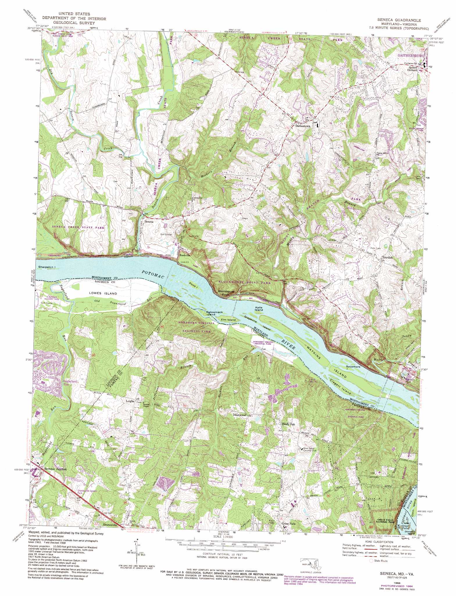
USGS Topo Quad 39077a3 - 1:24,000 scale
| Topo Map Name: | Seneca |
| USGS Topo Quad ID: | 39077a3 |
| Print Size: | ca. 21 1/4" wide x 27" high |
| Southeast Coordinates: | 39° N latitude / 77.25° W longitude |
| Map Center Coordinates: | 39.0625° N latitude / 77.3125° W longitude |
| U.S. States: | MD, VA |
| Filename: | o39077a3.jpg |
| Download Map JPG Image: | Seneca topo map 1:24,000 scale |
| Map Type: | Topographic |
| Topo Series: | 7.5´ |
| Map Scale: | 1:24,000 |
| Source of Map Images: | United States Geological Survey (USGS) |
| Alternate Map Versions: |
Seneca MD 1952, updated 1954 Download PDF Buy paper map Seneca MD 1952, updated 1954 Download PDF Buy paper map Seneca MD 1952, updated 1957 Download PDF Buy paper map Seneca MD 1952, updated 1963 Download PDF Buy paper map Seneca MD 1968, updated 1970 Download PDF Buy paper map Seneca MD 1968, updated 1980 Download PDF Buy paper map Seneca MD 1968, updated 1984 Download PDF Buy paper map Seneca MD 1968, updated 1984 Download PDF Buy paper map Seneca MD 1994, updated 1998 Download PDF Buy paper map Seneca MD 2011 Download PDF Buy paper map Seneca MD 2014 Download PDF Buy paper map Seneca MD 2016 Download PDF Buy paper map |
1:24,000 Topo Quads surrounding Seneca
Point Of Rocks |
Buckeystown |
Urbana |
Damascus |
Woodbine |
Waterford |
Poolesville |
Germantown |
Gaithersburg |
Sandy Spring |
Leesburg |
Sterling |
Seneca |
Rockville |
Kensington |
Arcola |
Herndon |
Vienna |
Falls Church |
Washington West |
Gainesville |
Manassas |
Fairfax |
Annandale |
Alexandria |
> Back to 39077a1 at 1:100,000 scale
> Back to 39076a1 at 1:250,000 scale
> Back to U.S. Topo Maps home
Seneca topo map: Gazetteer
Seneca: Areas
Seneca Breaks elevation 53m 173′Seneca: Bridges
Seneca Creek Aqueduct elevation 56m 183′Seneca: Capes
Blockhouse Point elevation 90m 295′Seneca: Crossings
Rowsers Ford elevation 55m 180′Seneca: Dams
Lock 22 elevation 53m 173′Lock 23 elevation 54m 177′
Lock 24 elevation 56m 183′
Seneca: Islands
Clagett Island elevation 54m 177′Elm Island elevation 56m 183′
Grapevine Island elevation 51m 167′
Harris Island elevation 54m 177′
Katie Island elevation 51m 167′
Lowes Island elevation 57m 187′
Patowmack Island elevation 55m 180′
Pond Island elevation 54m 177′
Sharpshin Island elevation 55m 180′
Sycamore Island elevation 49m 160′
Watkins Island elevation 51m 167′
Seneca: Mines
Seneca Quarry elevation 98m 321′Seneca: Parks
Aberdeen Park elevation 112m 367′Blockhouse Point Park elevation 83m 272′
Bretton Woods Recreation Center elevation 69m 226′
Cliff Bland Recreation Area elevation 125m 410′
Dierssen Waterfowl Sanctuary elevation 53m 173′
Dranesville Tavern Park elevation 90m 295′
Dry Seneca Creek Stream Valley Park elevation 73m 239′
Holly Knoll Park elevation 105m 344′
Northern Virginia Regional Park elevation 52m 170′
Orchard Park elevation 128m 419′
Riverbend Regional Park elevation 85m 278′
Riverview Park elevation 53m 173′
Seneca Creek State Park elevation 63m 206′
Tobytown Park elevation 95m 311′
Seneca: Populated Places
Ancient Oak elevation 121m 396′Ancient Oak North elevation 124m 406′
Ancient Oak West elevation 131m 429′
Beallmount elevation 100m 328′
Belvedere elevation 108m 354′
Bondbrook elevation 135m 442′
Brookmead elevation 117m 383′
Brookmead North elevation 114m 374′
Browns Corner elevation 126m 413′
Darnestown elevation 133m 436′
Darnestown Hills elevation 105m 344′
Darnestown Knolls elevation 120m 393′
Deakins Range elevation 107m 351′
Deanwood elevation 107m 351′
Dranesville elevation 129m 423′
Estates at Rivers Edge elevation 98m 321′
Esworthy Estates elevation 99m 324′
Esworthy Park elevation 97m 318′
Farmlands elevation 82m 269′
Fox Hills Green elevation 113m 370′
Fox Hills North elevation 109m 357′
Glen Query elevation 97m 318′
Harlow elevation 103m 337′
Hartley Hall Estates elevation 114m 374′
Harvest Hunt Farm elevation 105m 344′
Herndon Junction elevation 77m 252′
Highlands of Darnestown elevation 123m 403′
Lake Potomac elevation 76m 249′
Leighs elevation 118m 387′
Lowes Island elevation 57m 187′
Mills Farm elevation 110m 360′
Mills Farm East elevation 89m 291′
Mitchells Range elevation 121m 396′
Mountain View Estates elevation 133m 436′
North Potomac elevation 79m 259′
Pioneer Hills elevation 114m 374′
Polo Club Estates elevation 108m 354′
Potomac Chase elevation 108m 354′
Potomac Chase Estates elevation 104m 341′
Potomac Grove elevation 123m 403′
Potomac Park Estate elevation 101m 331′
Quail Run elevation 127m 416′
Quince Orchard elevation 132m 433′
Quince Orchard Knolls elevation 109m 357′
Ridgeland Farm Estates elevation 111m 364′
Rive Gauche Estates elevation 120m 393′
Riverwood elevation 85m 278′
Rushville elevation 59m 193′
Seneca elevation 59m 193′
Seneca Highlands elevation 126m 413′
Spring Meadows elevation 103m 337′
Stoney Creek Estates elevation 91m 298′
Stoney Creek Farm elevation 94m 308′
Tobytown elevation 95m 311′
Travilah elevation 107m 351′
Travilah Acres elevation 98m 321′
Travilah Meadows elevation 103m 337′
Willow Ridge elevation 131m 429′
Windmill Farm elevation 101m 331′
Woodbyran Farms elevation 115m 377′
Seneca: Springs
Herron Spring elevation 71m 232′Seneca: Streams
Dry Seneca Creek elevation 62m 203′Greenbrier Branch elevation 66m 216′
Hookers Branch elevation 62m 203′
Jefferson Branch elevation 65m 213′
Muddy Branch elevation 71m 232′
Muddy Branch elevation 50m 164′
Nichols Run elevation 49m 160′
Old Sugarland Run elevation 54m 177′
Russell Branch elevation 75m 246′
Sandy Branch elevation 50m 164′
Seneca Creek elevation 55m 180′
Sugarland Run elevation 55m 180′
Watts Branch elevation 51m 167′
Seneca: Trails
Meadow Trail elevation 78m 255′Paw Paw Passage Trail elevation 62m 203′
Potomac Heritage Trail elevation 56m 183′
Seneca digital topo map on disk
Buy this Seneca topo map showing relief, roads, GPS coordinates and other geographical features, as a high-resolution digital map file on DVD:
Atlantic Coast (NY, NJ, PA, DE, MD, VA, NC)
Buy digital topo maps: Atlantic Coast (NY, NJ, PA, DE, MD, VA, NC)
 map DVD")