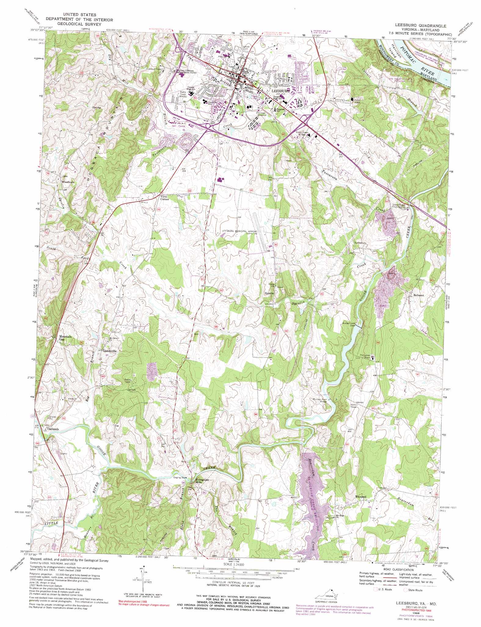
Leesburg Topo Map Virginia
To zoom in, hover over the map of Leesburg
USGS Topo Quad 39077a5 - 1:24,000 scale
| Topo Map Name: | Leesburg |
| USGS Topo Quad ID: | 39077a5 |
| Print Size: | ca. 21 1/4" wide x 27" high |
| Southeast Coordinates: | 39° N latitude / 77.5° W longitude |
| Map Center Coordinates: | 39.0625° N latitude / 77.5625° W longitude |
| U.S. States: | VA, MD |
| Filename: | o39077a5.jpg |
| Download Map JPG Image: | Leesburg topo map 1:24,000 scale |
| Map Type: | Topographic |
| Topo Series: | 7.5´ |
| Map Scale: | 1:24,000 |
| Source of Map Images: | United States Geological Survey (USGS) |
| Alternate Map Versions: |
Leesburg VA 1952, updated 1960 Download PDF Buy paper map Leesburg VA 1968, updated 1970 Download PDF Buy paper map Leesburg VA 1968, updated 1973 Download PDF Buy paper map Leesburg VA 1968, updated 1978 Download PDF Buy paper map Leesburg VA 1968, updated 1988 Download PDF Buy paper map Leesburg VA 1968, updated 1991 Download PDF Buy paper map Leesburg VA 1994, updated 1998 Download PDF Buy paper map Leesburg VA 2011 Download PDF Buy paper map Leesburg VA 2013 Download PDF Buy paper map Leesburg VA 2016 Download PDF Buy paper map |
1:24,000 Topo Quads surrounding Leesburg
Charles Town |
Harpers Ferry |
Point Of Rocks |
Buckeystown |
Urbana |
Round Hill |
Purcellville |
Waterford |
Poolesville |
Germantown |
Bluemont |
Lincoln |
Leesburg |
Sterling |
Seneca |
Rectortown |
Middleburg |
Arcola |
Herndon |
Vienna |
Marshall |
Thoroughfare Gap |
Gainesville |
Manassas |
Fairfax |
> Back to 39077a1 at 1:100,000 scale
> Back to 39076a1 at 1:250,000 scale
> Back to U.S. Topo Maps home
Leesburg topo map: Gazetteer
Leesburg: Airports
Leesburg Executive Airport elevation 116m 380′Loudoun Hospital Center Heliport elevation 111m 364′
Leesburg: Bridges
Dry Mill Bridge elevation 108m 354′Evergreen Mills Bridge elevation 75m 246′
Murrays Ford Bridge elevation 78m 255′
Leesburg: Dams
Beaverdam Dam elevation 76m 249′Goose Creek Dam elevation 71m 232′
Leesburg: Parks
Banshee Reeks Nature Preserve elevation 103m 337′Brandon Park elevation 89m 291′
Edgar Tillett Memorial Park elevation 105m 344′
Freedom Park elevation 115m 377′
Ida Lee Park and Recreation Center elevation 111m 364′
Keep Loudoun Beautiful Park elevation 72m 236′
Leesburg Animal Park elevation 126m 413′
Leesburg Historic District elevation 103m 337′
Oatlands Historic District elevation 86m 282′
Olde Izaak Walton Park elevation 99m 324′
Plaza Street Park elevation 100m 328′
Raflo Park elevation 98m 321′
Red Rock Overlook Regional Park elevation 75m 246′
Robinson Park elevation 96m 314′
Rotary Park elevation 99m 324′
Rust Sanctuary elevation 156m 511′
Smithsonian Naturalist Center elevation 114m 374′
Stone House at Harper Park elevation 87m 285′
Trailside Park elevation 90m 295′
Leesburg: Populated Places
Ashburn Farm elevation 89m 291′Belmont elevation 90m 295′
Belmont Greene elevation 91m 298′
Broadlands elevation 111m 364′
Compher elevation 77m 252′
Dunlin elevation 105m 344′
Evergreen Mills elevation 102m 334′
Gleedsville elevation 105m 344′
Graves elevation 95m 311′
Leesburg elevation 104m 341′
Little Washington elevation 142m 465′
Oatlands elevation 84m 275′
Sycolin elevation 111m 364′
Virts Corner elevation 120m 393′
Waxpool elevation 103m 337′
Woodburn elevation 149m 488′
Leesburg: Post Offices
Leesburg Post Office elevation 104m 341′Leesburg: Reservoirs
Beaverdam Reservoir elevation 76m 249′Goose Creek Reservoir elevation 71m 232′
Leesburg: Streams
Beaverdam Creek elevation 75m 246′Big Branch elevation 79m 259′
Black Branch elevation 76m 249′
Dry Mill Branch elevation 97m 318′
Howsers Branch elevation 82m 269′
Little River elevation 79m 259′
South Fork Sycolin Creek elevation 111m 364′
Sycolin Creek elevation 65m 213′
Tan Branch elevation 76m 249′
Town Branch elevation 92m 301′
Tuscarora Creek elevation 59m 193′
Leesburg: Summits
Hogback Mountain elevation 186m 610′Leesburg digital topo map on disk
Buy this Leesburg topo map showing relief, roads, GPS coordinates and other geographical features, as a high-resolution digital map file on DVD:
Atlantic Coast (NY, NJ, PA, DE, MD, VA, NC)
Buy digital topo maps: Atlantic Coast (NY, NJ, PA, DE, MD, VA, NC)
 map DVD")