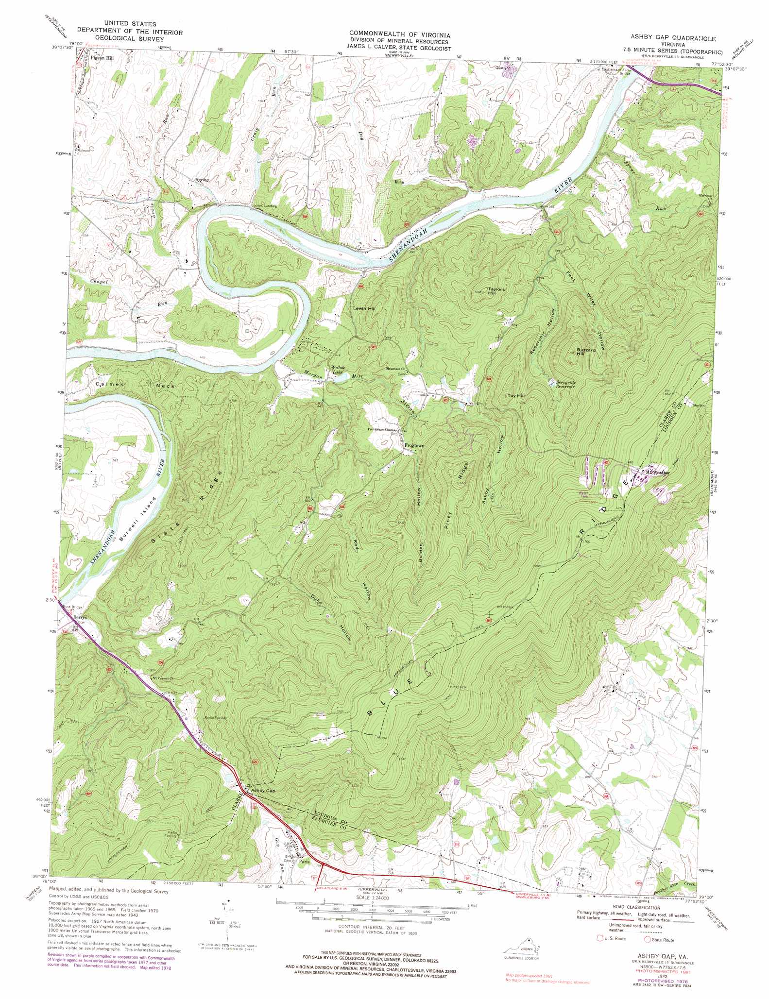
Ashby Gap Topo Map Virginia
To zoom in, hover over the map of Ashby Gap
USGS Topo Quad 39077a8 - 1:24,000 scale
| Topo Map Name: | Ashby Gap |
| USGS Topo Quad ID: | 39077a8 |
| Print Size: | ca. 21 1/4" wide x 27" high |
| Southeast Coordinates: | 39° N latitude / 77.875° W longitude |
| Map Center Coordinates: | 39.0625° N latitude / 77.9375° W longitude |
| U.S. State: | VA |
| Filename: | o39077a8.jpg |
| Download Map JPG Image: | Ashby Gap topo map 1:24,000 scale |
| Map Type: | Topographic |
| Topo Series: | 7.5´ |
| Map Scale: | 1:24,000 |
| Source of Map Images: | United States Geological Survey (USGS) |
| Alternate Map Versions: |
Ashby Gap VA 1943, updated 1961 Download PDF Buy paper map Ashby Gap VA 1970, updated 1971 Download PDF Buy paper map Ashby Gap VA 1970, updated 1976 Download PDF Buy paper map Ashby Gap VA 1970, updated 1978 Download PDF Buy paper map Ashby Gap VA 1970, updated 1983 Download PDF Buy paper map Ashby Gap VA 2010 Download PDF Buy paper map Ashby Gap VA 2013 Download PDF Buy paper map Ashby Gap VA 2016 Download PDF Buy paper map |
1:24,000 Topo Quads surrounding Ashby Gap
White Hall |
Inwood |
Middleway |
Charles Town |
Harpers Ferry |
Winchester |
Stephenson |
Berryville |
Round Hill |
Purcellville |
Stephens City |
Boyce |
Ashby Gap |
Bluemont |
Lincoln |
Front Royal |
Linden |
Upperville |
Rectortown |
Middleburg |
Chester Gap |
Flint Hill |
Orlean |
Marshall |
Thoroughfare Gap |
> Back to 39077a1 at 1:100,000 scale
> Back to 39076a1 at 1:250,000 scale
> Back to U.S. Topo Maps home
Ashby Gap topo map: Gazetteer
Ashby Gap: Bridges
Byrd Bridge elevation 126m 413′Castlemans Ferry Bridge elevation 113m 370′
Trap Bridge elevation 165m 541′
Ashby Gap: Capes
Calmes Neck elevation 160m 524′Ashby Gap: Crossings
Berrys Ferry (historical) elevation 126m 413′Castleman Ferry (historical) elevation 114m 374′
Ashby Gap: Dams
Short Hill Farm Dam elevation 128m 419′Ashby Gap: Gaps
Ashby Gap elevation 313m 1026′Ashby Gap: Islands
Burwell Island elevation 128m 419′Ashby Gap: Parks
Watermelon Park elevation 136m 446′Ashby Gap: Populated Places
Ashby Gap Estates elevation 300m 984′Ashby Run elevation 257m 843′
Barker Land elevation 465m 1525′
Berrys elevation 133m 436′
Calmes Neck Estates elevation 172m 564′
Care Free Acres elevation 230m 754′
Castlemans Ferry elevation 129m 423′
Chilly Hollow Estates elevation 147m 482′
Fisher Hill elevation 205m 672′
Frogtown elevation 213m 698′
Lockes Landing elevation 131m 429′
Longwood elevation 187m 613′
Mountain Lake elevation 202m 662′
Paris elevation 245m 803′
Paris Heights elevation 442m 1450′
Pine Acres elevation 206m 675′
River Park elevation 159m 521′
Spout Run elevation 213m 698′
Top Hill elevation 181m 593′
Willow Lake elevation 147m 482′
Ashby Gap: Post Offices
Paris Post Office elevation 248m 813′Ashby Gap: Reservoirs
Berryville Reservoir elevation 257m 843′Short Hill Farm Lake elevation 128m 419′
Willow Lake elevation 143m 469′
Ashby Gap: Ridges
Piney Ridge elevation 376m 1233′Slate Ridge elevation 275m 902′
Ashby Gap: Streams
Chapel Run elevation 122m 400′Craig Run elevation 117m 383′
Dog Run elevation 116m 380′
Lewis Run elevation 122m 400′
Morgan Mill Stream elevation 123m 403′
Spout Run elevation 116m 380′
Ashby Gap: Summits
Buzzard Hill elevation 387m 1269′Lewin Hill elevation 244m 800′
Taylors Hill elevation 305m 1000′
Toy Hill elevation 364m 1194′
Ashby Gap: Valleys
Ashby Hollow elevation 499m 1637′Duke Hollow elevation 231m 757′
Fent Wiley Hollow elevation 162m 531′
Reservoir Hollow elevation 177m 580′
Rod Hollow elevation 197m 646′
Ashby Gap digital topo map on disk
Buy this Ashby Gap topo map showing relief, roads, GPS coordinates and other geographical features, as a high-resolution digital map file on DVD:
Atlantic Coast (NY, NJ, PA, DE, MD, VA, NC)
Buy digital topo maps: Atlantic Coast (NY, NJ, PA, DE, MD, VA, NC)
 map DVD")