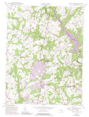
Sandy Spring Topo Map Maryland
To zoom in, hover over the map of Sandy Spring
USGS Topo Quad 39077b1 - 1:24,000 scale
| Topo Map Name: | Sandy Spring |
| USGS Topo Quad ID: | 39077b1 |
| Print Size: | ca. 21 1/4" wide x 27" high |
| Southeast Coordinates: | 39.125° N latitude / 77° W longitude |
| Map Center Coordinates: | 39.1875° N latitude / 77.0625° W longitude |
| U.S. State: | MD |
| Filename: | o39077b1.jpg |
| Download Map JPG Image: | Sandy Spring topo map 1:24,000 scale |
| Map Type: | Topographic |
| Topo Series: | 7.5´ |
| Map Scale: | 1:24,000 |
| Source of Map Images: | United States Geological Survey (USGS) |
| Alternate Map Versions: |
Sandy Spring MD 1945, updated 1959 Download PDF Buy paper map Sandy Spring MD 1945, updated 1965 Download PDF Buy paper map Sandy Spring MD 1945, updated 1972 Download PDF Buy paper map Sandy Spring MD 1945, updated 1979 Download PDF Buy paper map Sandy Spring MD 1945, updated 1988 Download PDF Buy paper map Sandy Spring MD 1950 Download PDF Buy paper map Sandy Spring MD 1950 Download PDF Buy paper map Sandy Spring MD 1981, updated 1986 Download PDF Buy paper map Sandy Spring MD 1988, updated 1996 Download PDF Buy paper map Sandy Spring MD 2011 Download PDF Buy paper map Sandy Spring MD 2014 Download PDF Buy paper map Sandy Spring MD 2016 Download PDF Buy paper map |
1:24,000 Topo Quads surrounding Sandy Spring
> Back to 39077a1 at 1:100,000 scale
> Back to 39076a1 at 1:250,000 scale
> Back to U.S. Topo Maps home
Sandy Spring topo map: Gazetteer
Sandy Spring: Airports
Federal Support Center Heliport elevation 153m 501′Waredaca Farm Airport elevation 163m 534′
Sandy Spring: Dams
Brighton Dam elevation 101m 331′Brighton Dam elevation 110m 360′
Sandy Spring: Parks
Bowie Mill Park elevation 141m 462′Brook Manor Park elevation 152m 498′
Cashell Road Park elevation 126m 413′
Greenwood Park elevation 148m 485′
Griffith Park elevation 164m 538′
Hawlings River Regional Park elevation 107m 351′
Longwood Park elevation 140m 459′
Longwood Recreation Center elevation 140m 459′
Mount Zion Park elevation 154m 505′
Muncaster Manor Park elevation 151m 495′
Olney Square Park elevation 139m 456′
Rachel Carson Conservation Park elevation 122m 400′
Reedy Branch Park elevation 145m 475′
Southeast Olney Park elevation 160m 524′
Woodlawn Park elevation 130m 426′
Sandy Spring: Populated Places
Abrams elevation 124m 406′Anscroft elevation 136m 446′
Ashley Manor elevation 124m 406′
Ashton elevation 152m 498′
Ashton Manor elevation 140m 459′
Ashton Preserve elevation 129m 423′
Ashton River Estates elevation 109m 357′
Avenel elevation 142m 465′
Bowie Mill Estates elevation 141m 462′
Bowie Mill Park elevation 137m 449′
Briars Acres elevation 146m 479′
Brighton elevation 148m 485′
Brighton Estates elevation 142m 465′
Brighton Knolls elevation 140m 459′
Brinklow elevation 140m 459′
Brooke Meadow elevation 132m 433′
Brookemanor Estates elevation 128m 419′
Brookeville elevation 133m 436′
Brookeville Heights elevation 138m 452′
Brookeville Knolls elevation 153m 501′
Camelback Village elevation 166m 544′
Cashell Manor elevation 128m 419′
Cashell Woods elevation 139m 456′
Cherry Valley elevation 151m 495′
Cherrywood elevation 139m 456′
Claysville elevation 172m 564′
Dellabrooke Estates elevation 124m 406′
Denit Estates elevation 143m 469′
Dobridge elevation 138m 452′
Ednor Highlands elevation 145m 475′
Ednor Woods elevation 150m 492′
Fairhill elevation 160m 524′
Flintridge elevation 177m 580′
Gold Mine Crossing elevation 131m 429′
Granby Woods elevation 159m 521′
Griffith Park elevation 165m 541′
Hallowell elevation 160m 524′
Hawlings Hills elevation 124m 406′
Hawlings Meadow elevation 155m 508′
Hawlings River Estates elevation 106m 347′
Hawlings View elevation 142m 465′
Highlands of Olney elevation 166m 544′
Holiday Hills elevation 136m 446′
Karinwood elevation 122m 400′
Manor Oaks elevation 126m 413′
Mount Zion elevation 157m 515′
Muncaster Manor elevation 154m 505′
Norbeck Estates elevation 142m 465′
Norbrook Village elevation 152m 498′
Norwood elevation 129m 423′
Oakdale elevation 156m 511′
Olney elevation 165m 541′
Olney Acres elevation 133m 436′
Olney Estates elevation 142m 465′
Olney Mill elevation 141m 462′
Olney Oaks elevation 143m 469′
Olney Square elevation 138m 452′
Olney Town elevation 162m 531′
Quail Hill elevation 123m 403′
Rolling Knolls elevation 154m 505′
Sam Rice Manor elevation 148m 485′
Sandy Spring elevation 149m 488′
Sandy Spring Meadow elevation 145m 475′
Sunnymeade elevation 111m 364′
Sunshine elevation 158m 518′
Sunshine Acres elevation 153m 501′
Tanterra elevation 150m 492′
Timberland Estates elevation 143m 469′
Towne Centre Place elevation 168m 551′
Triadelphia (historical) elevation 110m 360′
Triadelphia (historical) elevation 113m 370′
Twist and Turn Estates elevation 135m 442′
Unity elevation 164m 538′
Willett Estates elevation 159m 521′
Williamsburg Village elevation 141m 462′
Sandy Spring: Post Offices
Ashton Post Office elevation 149m 488′Brinklow Post Office elevation 134m 439′
Brookeville Post Office elevation 131m 429′
Olney Post Office elevation 153m 501′
Sandy Spring Post Office elevation 148m 485′
Sandy Spring: Reservoirs
Triadelphia Reservoir elevation 101m 331′Tridelphia Reservoir elevation 110m 360′
Sandy Spring: Streams
Cattail Creek elevation 110m 360′Haights Branch elevation 118m 387′
Hawlings River elevation 90m 295′
James Creek elevation 94m 308′
Reddy Branch elevation 98m 321′
Williamsburg Run elevation 113m 370′
Sandy Spring digital topo map on disk
Buy this Sandy Spring topo map showing relief, roads, GPS coordinates and other geographical features, as a high-resolution digital map file on DVD:
Atlantic Coast (NY, NJ, PA, DE, MD, VA, NC)
Buy digital topo maps: Atlantic Coast (NY, NJ, PA, DE, MD, VA, NC)


