Round Hill Topo Map West Virginia
To zoom in, hover over the map of Round Hill
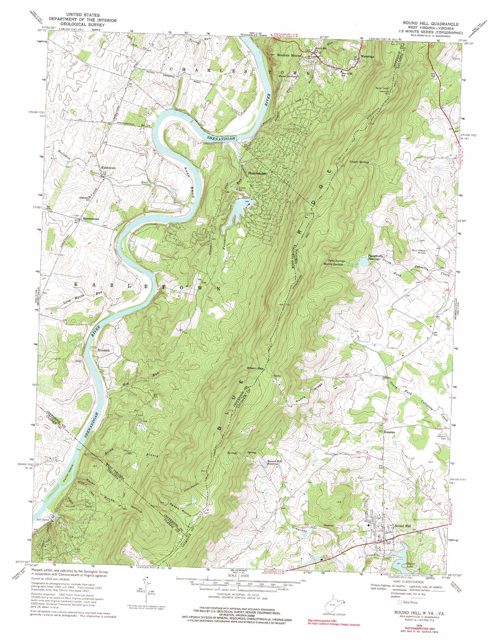
USGS Topo Quad 39077b7 - 1:24,000 scale
| Topo Map Name: | Round Hill |
| USGS Topo Quad ID: | 39077b7 |
| Print Size: | ca. 21 1/4" wide x 27" high |
| Southeast Coordinates: | 39.125° N latitude / 77.75° W longitude |
| Map Center Coordinates: | 39.1875° N latitude / 77.8125° W longitude |
| U.S. States: | WV, VA |
| Filename: | o39077b7.jpg |
| Download Map JPG Image: | Round Hill topo map 1:24,000 scale |
| Map Type: | Topographic |
| Topo Series: | 7.5´ |
| Map Scale: | 1:24,000 |
| Source of Map Images: | United States Geological Survey (USGS) |
| Alternate Map Versions: |
Round Hill VA 1953, updated 1953 Download PDF Buy paper map Round Hill VA 1970, updated 1971 Download PDF Buy paper map Round Hill VA 1970, updated 1974 Download PDF Buy paper map Round Hill VA 1970, updated 1990 Download PDF Buy paper map Round Hill VA 1997, updated 2001 Download PDF Buy paper map Round Hill VA 2010 Download PDF Buy paper map Round Hill VA 2013 Download PDF Buy paper map Round Hill VA 2016 Download PDF Buy paper map |
1:24,000 Topo Quads surrounding Round Hill
Tablers Station |
Martinsburg |
Shepherdstown |
Keedysville |
Middletown |
Inwood |
Middleway |
Charles Town |
Harpers Ferry |
Point Of Rocks |
Stephenson |
Berryville |
Round Hill |
Purcellville |
Waterford |
Boyce |
Ashby Gap |
Bluemont |
Lincoln |
Leesburg |
Linden |
Upperville |
Rectortown |
Middleburg |
Arcola |
> Back to 39077a1 at 1:100,000 scale
> Back to 39076a1 at 1:250,000 scale
> Back to U.S. Topo Maps home
Round Hill topo map: Gazetteer
Round Hill: Airports
Birch Hollow Airport elevation 189m 620′Round Hill: Bends
Avon Bend elevation 123m 403′Round Hill: Crossings
Boyds Ferry (historical) elevation 108m 354′Parkers Ford (historical) elevation 111m 364′
Shannondale Ferry (historical) elevation 104m 341′
Round Hill: Dams
Furnace Run Dam Site elevation 189m 620′Purcellville Dam elevation 226m 741′
Round Hill: Gaps
Wilson Gap elevation 440m 1443′Wilson Gap elevation 441m 1446′
Round Hill: Islands
Parker Island elevation 111m 364′Round Hill: Parks
Shannondale Springs Wildlife Management Area elevation 141m 462′Woodgrove Park elevation 189m 620′
Round Hill: Populated Places
Edgegrove elevation 192m 629′Eubanks elevation 200m 656′
Kabletown elevation 122m 400′
Mannings elevation 184m 603′
Meyerstown elevation 145m 475′
Miller elevation 214m 702′
Mountain Mission elevation 144m 472′
Riverside elevation 129m 423′
Round Hill elevation 167m 547′
Shannondale elevation 171m 561′
Shenandoah Retreat elevation 166m 544′
Sunny Ridge elevation 370m 1213′
Valley View elevation 407m 1335′
Round Hill: Post Offices
Round Hill Post Office elevation 168m 551′Round Hill: Reservoirs
Purcellville Reservoir elevation 226m 741′Round Hill Reservoir elevation 269m 882′
Round Hill: Ridges
Sunny Ridge elevation 326m 1069′Round Hill: Springs
Cooper Springs elevation 271m 889′Harris Springs elevation 249m 816′
John Bayles Farm Spring elevation 177m 580′
Maisie Ware Farm Spring elevation 129m 423′
Meyers Farm Spring elevation 187m 613′
Mountain Mission Spring elevation 177m 580′
Potts Springs elevation 300m 984′
Robert Smith Farm Spring elevation 141m 462′
Shannon Hill Spring elevation 115m 377′
Shannondale Blue Sulphur Spring elevation 108m 354′
Shannondale Red Sulphur Spring elevation 108m 354′
Shannondale White Sulphur Spring elevation 108m 354′
Tom Painter Farm Spring elevation 161m 528′
Round Hill: Streams
Bullskin Run elevation 107m 351′Furnace Run elevation 101m 331′
Hog Run elevation 111m 364′
Long Marsh Run elevation 108m 354′
Long Marsh Run elevation 108m 354′
Rocky Branch elevation 111m 364′
Rocky Branch elevation 111m 364′
Simpsons Creek elevation 150m 492′
Round Hill: Summits
Raven Rocks elevation 439m 1440′Round Hill: Valleys
Raven Rocks Hollow elevation 112m 367′Round Hill digital topo map on disk
Buy this Round Hill topo map showing relief, roads, GPS coordinates and other geographical features, as a high-resolution digital map file on DVD:
Atlantic Coast (NY, NJ, PA, DE, MD, VA, NC)
Buy digital topo maps: Atlantic Coast (NY, NJ, PA, DE, MD, VA, NC)
 map DVD")