Point Of Rocks Topo Map Maryland
To zoom in, hover over the map of Point Of Rocks
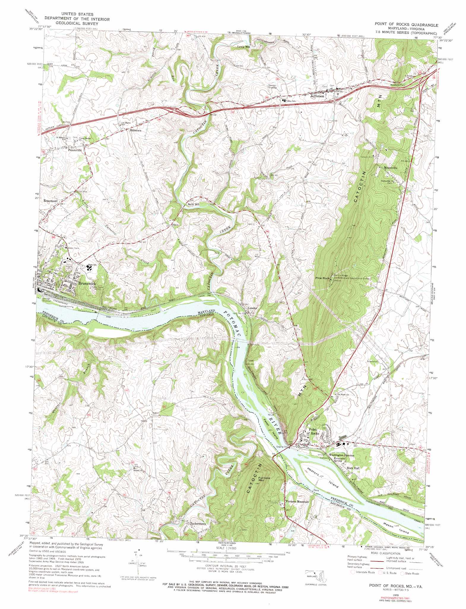
USGS Topo Quad 39077c5 - 1:24,000 scale
| Topo Map Name: | Point Of Rocks |
| USGS Topo Quad ID: | 39077c5 |
| Print Size: | ca. 21 1/4" wide x 27" high |
| Southeast Coordinates: | 39.25° N latitude / 77.5° W longitude |
| Map Center Coordinates: | 39.3125° N latitude / 77.5625° W longitude |
| U.S. States: | MD, VA |
| Filename: | o39077c5.jpg |
| Download Map JPG Image: | Point Of Rocks topo map 1:24,000 scale |
| Map Type: | Topographic |
| Topo Series: | 7.5´ |
| Map Scale: | 1:24,000 |
| Source of Map Images: | United States Geological Survey (USGS) |
| Alternate Map Versions: |
Point Of Rocks MD 1953 Download PDF Buy paper map Point of Rocks MD 1953 Download PDF Buy paper map Point Of Rocks MD 1955, updated 1956 Download PDF Buy paper map Point Of Rocks MD 1955, updated 1962 Download PDF Buy paper map Point Of Rocks MD 1970, updated 1972 Download PDF Buy paper map Point Of Rocks MD 1970, updated 1991 Download PDF Buy paper map Point of Rocks MD 2011 Download PDF Buy paper map Point of Rocks MD 2014 Download PDF Buy paper map Point of Rocks MD 2016 Download PDF Buy paper map |
1:24,000 Topo Quads surrounding Point Of Rocks
Williamsport |
Funkstown |
Myersville |
Catoctin Furnace |
Woodsboro |
Shepherdstown |
Keedysville |
Middletown |
Frederick |
Walkersville |
Charles Town |
Harpers Ferry |
Point Of Rocks |
Buckeystown |
Urbana |
Round Hill |
Purcellville |
Waterford |
Poolesville |
Germantown |
Bluemont |
Lincoln |
Leesburg |
Sterling |
Seneca |
> Back to 39077a1 at 1:100,000 scale
> Back to 39076a1 at 1:250,000 scale
> Back to U.S. Topo Maps home
Point Of Rocks topo map: Gazetteer
Point Of Rocks: Bridges
Catoctin Creek Aqueduct elevation 61m 200′Point Of Rocks: Crossings
Interchange 10 elevation 161m 528′Interchange 4 elevation 133m 436′
Interchange 8 elevation 164m 538′
Point Of Rocks: Dams
Gore Dam elevation 97m 318′Lock Number 28 elevation 75m 246′
Lock Number 29 elevation 71m 232′
Point Of Rocks: Islands
Heaters Island elevation 70m 229′Mason Island elevation 67m 219′
Paton Island elevation 66m 216′
Point Of Rocks: Parks
Brunswick City Park elevation 111m 364′Brunswick Historic District elevation 96m 314′
Brunswick Riverside Park elevation 70m 229′
Heaters Island Wildlife Management Area elevation 70m 229′
Point of Rocks Community Park elevation 81m 265′
Taylorstown Historic District elevation 91m 298′
Point Of Rocks: Pillars
Calico Rocks elevation 67m 219′Point Of Rocks: Populated Places
Adamstown Village elevation 104m 341′Bells Mill elevation 84m 275′
Boss Arnold Village elevation 129m 423′
Bradbury Heights elevation 128m 419′
Briercrest Heights elevation 175m 574′
Burgee elevation 153m 501′
Canavest (historical) elevation 67m 219′
Catoctin Point elevation 202m 662′
Concord elevation 160m 524′
Copperfield elevation 154m 505′
Eastwick elevation 131m 429′
EcoVillage of Loudoun County elevation 110m 360′
Fairview elevation 136m 446′
Furnace Mountain elevation 86m 282′
Jefferson elevation 178m 583′
Jefferson Court elevation 181m 593′
Jefferson Heights elevation 212m 695′
Jefferson Oaks elevation 138m 452′
Jefferson View elevation 134m 439′
Lander elevation 91m 298′
Lewis Mill elevation 95m 311′
Mar-Lu-Ridge Vista elevation 150m 492′
Merry Midnight elevation 144m 472′
Middlebrook elevation 138m 452′
Mountville elevation 214m 702′
Olive elevation 134m 439′
Petersville elevation 157m 515′
Point of Rocks elevation 77m 252′
Point of Rocks Estates elevation 100m 328′
Potomac Gateway elevation 149m 488′
Potomac Overlook elevation 146m 479′
Potomac Village elevation 100m 328′
Profit Acres elevation 93m 305′
Rock Hall elevation 72m 236′
Rosemont elevation 153m 501′
Roundtree elevation 152m 498′
Slabtown elevation 154m 505′
Springview elevation 149m 488′
Stockman Estates elevation 159m 521′
Sunrise elevation 123m 403′
Taylorstown elevation 91m 298′
Virts elevation 140m 459′
Washington Junction elevation 70m 229′
Wilber Woods elevation 140m 459′
Point Of Rocks: Post Offices
Jefferson Post Office elevation 168m 551′Point of Rocks Post Office elevation 76m 249′
Point Of Rocks: Reservoirs
Gore Pond elevation 97m 318′Point Of Rocks: Springs
Kanawha Spring elevation 67m 219′Point Of Rocks: Streams
Broad Run elevation 85m 278′Catoctin Creek elevation 66m 216′
Catoctin Creek elevation 66m 216′
Lander Branch elevation 61m 200′
Lewis Mill Branch elevation 95m 311′
Little Catoctin Creek elevation 66m 216′
Quarter Branch elevation 66m 216′
Washington Run elevation 63m 206′
Point Of Rocks: Summits
Furnace Mountain elevation 269m 882′Pine Rock elevation 345m 1131′
Point Of Rocks digital topo map on disk
Buy this Point Of Rocks topo map showing relief, roads, GPS coordinates and other geographical features, as a high-resolution digital map file on DVD:
Atlantic Coast (NY, NJ, PA, DE, MD, VA, NC)
Buy digital topo maps: Atlantic Coast (NY, NJ, PA, DE, MD, VA, NC)
 map DVD")