Winfield Topo Map Maryland
To zoom in, hover over the map of Winfield
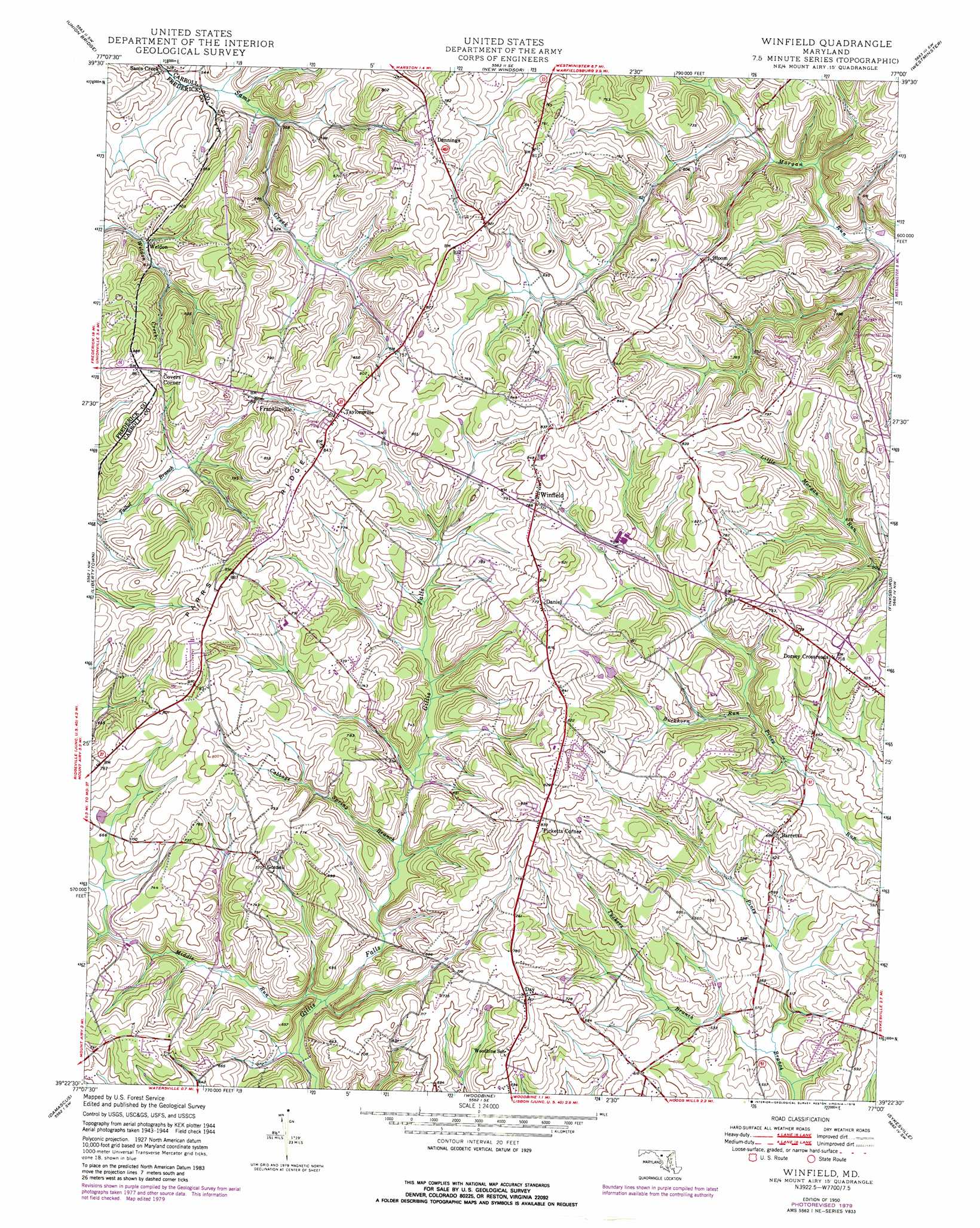
USGS Topo Quad 39077d1 - 1:24,000 scale
| Topo Map Name: | Winfield |
| USGS Topo Quad ID: | 39077d1 |
| Print Size: | ca. 21 1/4" wide x 27" high |
| Southeast Coordinates: | 39.375° N latitude / 77° W longitude |
| Map Center Coordinates: | 39.4375° N latitude / 77.0625° W longitude |
| U.S. State: | MD |
| Filename: | o39077d1.jpg |
| Download Map JPG Image: | Winfield topo map 1:24,000 scale |
| Map Type: | Topographic |
| Topo Series: | 7.5´ |
| Map Scale: | 1:24,000 |
| Source of Map Images: | United States Geological Survey (USGS) |
| Alternate Map Versions: |
Winfield MD 1950 Download PDF Buy paper map Winfield MD 1950 Download PDF Buy paper map Winfield MD 1950, updated 1972 Download PDF Buy paper map Winfield MD 1950, updated 1979 Download PDF Buy paper map Winfield MD 1950, updated 1979 Download PDF Buy paper map Winfield MD 2011 Download PDF Buy paper map Winfield MD 2014 Download PDF Buy paper map Winfield MD 2016 Download PDF Buy paper map |
1:24,000 Topo Quads surrounding Winfield
Emmitsburg |
Taneytown |
Littlestown |
Manchester |
Lineboro |
Woodsboro |
Union Bridge |
New Windsor |
Westminister |
Hampstead |
Walkersville |
Libertytown |
Winfield |
Finksburg |
Reisterstown |
Urbana |
Damascus |
Woodbine |
Sykesville |
Ellicott City |
Germantown |
Gaithersburg |
Sandy Spring |
Clarksville |
Savage |
> Back to 39077a1 at 1:100,000 scale
> Back to 39076a1 at 1:250,000 scale
> Back to U.S. Topo Maps home
Winfield topo map: Gazetteer
Winfield: Airports
Clearview Airpark elevation 238m 780′Walters Airport elevation 221m 725′
Woodbine Gliderport elevation 209m 685′
Winfield: Parks
Mayeski Park elevation 229m 751′Salt Box Park elevation 207m 679′
Winfield: Populated Places
Academy Acres elevation 243m 797′Airport Acres elevation 253m 830′
Arthur Ridge elevation 233m 764′
Ashley Mobile Home Park elevation 267m 875′
Atkins Acres elevation 228m 748′
Barrett elevation 209m 685′
Belmar Estates elevation 257m 843′
Benders Heights elevation 238m 780′
Blankner Hill elevation 204m 669′
Bloom elevation 229m 751′
Braddock Estates elevation 240m 787′
Braddock Manor West elevation 236m 774′
Buckhorn Run elevation 193m 633′
Buffalo Estates elevation 243m 797′
Buffalo Hills elevation 256m 839′
Bushey Heights elevation 231m 757′
Carroll Woods Estates elevation 258m 846′
Chases Forest elevation 211m 692′
Chestnut Oaks elevation 230m 754′
Covers Corner elevation 262m 859′
Cumorah Estates elevation 241m 790′
Daisy Meadows elevation 184m 603′
Dales Delight elevation 229m 751′
Daniel elevation 237m 777′
Day elevation 237m 777′
Dennings elevation 242m 793′
Dogwood Estates elevation 192m 629′
Dorsey Crossroads elevation 222m 728′
Dorsey Hill elevation 175m 574′
Dotsons Ridge elevation 258m 846′
Dulany Hills elevation 251m 823′
Eagle Wood Estates elevation 215m 705′
Elbeekay Farms elevation 244m 800′
Equestrian Estates elevation 232m 761′
Fischer elevation 244m 800′
Fleming Way Estates elevation 236m 774′
Flowerwood Estates elevation 239m 784′
Franklinville elevation 227m 744′
Gasnell Estates elevation 246m 807′
Gilboa elevation 213m 698′
Gillis Falls Estates elevation 224m 734′
Glenvue Acres elevation 262m 859′
Gosnell elevation 218m 715′
Grahams Green Acres elevation 233m 764′
Hazels Woods elevation 211m 692′
Heather Ridge elevation 204m 669′
Heritage elevation 241m 790′
Huntfield elevation 244m 800′
Ivy Hill Way elevation 247m 810′
Kimberly Heights elevation 221m 725′
Latigo Trails elevation 237m 777′
Legos Choice elevation 249m 816′
Manahan (historical) elevation 253m 830′
McHenry Meadows elevation 225m 738′
Monks Misery elevation 197m 646′
Montclare elevation 252m 826′
Mountain Vista elevation 263m 862′
New Horizons elevation 253m 830′
New Venture Estates elevation 212m 695′
Oceola Estates elevation 245m 803′
Olde Oak Run elevation 218m 715′
Olde Washington Valley elevation 245m 803′
Picketts Corner elevation 261m 856′
Piney Run Estates elevation 212m 695′
Poignant Acres elevation 256m 839′
Quail Creek Acres elevation 171m 561′
Raydan Retreat elevation 245m 803′
Ray-Mar Estates elevation 268m 879′
Red Fox Meadow elevation 219m 718′
Ritter elevation 265m 869′
River Wood Hills elevation 212m 695′
Rolling Carroll Estates elevation 230m 754′
Rolling Hills elevation 177m 580′
Sams Creek elevation 169m 554′
Sanner Estates elevation 166m 544′
Shawns Landing elevation 189m 620′
South Carroll Estates elevation 237m 777′
Stanton Heights elevation 259m 849′
Stone House Village elevation 246m 807′
Stoney Ridge elevation 253m 830′
Streamwood elevation 214m 702′
Sun Valley elevation 255m 836′
Sun Valley Farms elevation 253m 830′
Tarson Manor elevation 205m 672′
Taylorsville elevation 254m 833′
Timber Ridge elevation 253m 830′
Timbermead elevation 216m 708′
Valley Hill Farms elevation 231m 757′
Villa Tomarchio elevation 214m 702′
Village Green Estates elevation 233m 764′
Watersville Acres elevation 207m 679′
Weldon elevation 197m 646′
White Rock elevation 189m 620′
Wild Lake Estates elevation 184m 603′
Winfield elevation 252m 826′
Winfield Heights elevation 245m 803′
Winfield Woods elevation 259m 849′
Woodbine Acres elevation 237m 777′
Woodbridge elevation 265m 869′
Winfield: Ridges
Parrs Ridge elevation 273m 895′Winfield: Streams
Buckhorn Run elevation 194m 636′Cabbage Spring Branch elevation 188m 616′
Middle Run elevation 164m 538′
Morgan Creek elevation 176m 577′
Tuckers Branch elevation 145m 475′
Winfield digital topo map on disk
Buy this Winfield topo map showing relief, roads, GPS coordinates and other geographical features, as a high-resolution digital map file on DVD:
Atlantic Coast (NY, NJ, PA, DE, MD, VA, NC)
Buy digital topo maps: Atlantic Coast (NY, NJ, PA, DE, MD, VA, NC)
 map DVD")