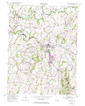
Union Bridge Topo Map Maryland
To zoom in, hover over the map of Union Bridge
USGS Topo Quad 39077e2 - 1:24,000 scale
| Topo Map Name: | Union Bridge |
| USGS Topo Quad ID: | 39077e2 |
| Print Size: | ca. 21 1/4" wide x 27" high |
| Southeast Coordinates: | 39.5° N latitude / 77.125° W longitude |
| Map Center Coordinates: | 39.5625° N latitude / 77.1875° W longitude |
| U.S. State: | MD |
| Filename: | o39077e2.jpg |
| Download Map JPG Image: | Union Bridge topo map 1:24,000 scale |
| Map Type: | Topographic |
| Topo Series: | 7.5´ |
| Map Scale: | 1:24,000 |
| Source of Map Images: | United States Geological Survey (USGS) |
| Alternate Map Versions: |
Union Bridge MD 1953, updated 1955 Download PDF Buy paper map Union Bridge MD 1953, updated 1966 Download PDF Buy paper map Union Bridge MD 1953, updated 1972 Download PDF Buy paper map Union Bridge MD 2011 Download PDF Buy paper map Union Bridge MD 2014 Download PDF Buy paper map Union Bridge MD 2016 Download PDF Buy paper map |
1:24,000 Topo Quads surrounding Union Bridge
> Back to 39077e1 at 1:100,000 scale
> Back to 39076a1 at 1:250,000 scale
> Back to U.S. Topo Maps home
Union Bridge topo map: Gazetteer
Union Bridge: Airports
Keymar Airpark elevation 138m 452′M R P Airpark elevation 166m 544′
Union Bridge: Parks
Hard Lodging Historic Site elevation 137m 449′Linwood Historic District elevation 130m 426′
Union Bridge Community Park elevation 157m 515′
Union Bridge: Populated Places
Bark Hill elevation 181m 593′Bellevue Heights elevation 145m 475′
Bethel elevation 144m 472′
Bruceville elevation 114m 374′
Bunker Hill Estates elevation 174m 570′
Clemsonville elevation 156m 511′
Coppermine Estates elevation 193m 633′
Crouse Mill elevation 121m 396′
Edgewood elevation 220m 721′
Englars Mill elevation 162m 531′
Fairview Acres elevation 163m 534′
Feesersburg elevation 158m 518′
Frederick (historical) elevation 146m 479′
Glenn Hill elevation 182m 597′
Grossnickle elevation 186m 610′
Harmon Haven elevation 168m 551′
Hidden Creek elevation 133m 436′
Johnsville elevation 183m 600′
Key Heights elevation 181m 593′
Keymar elevation 139m 456′
Keyview elevation 192m 629′
Linwood elevation 131m 429′
Lovejoy Estates elevation 160m 524′
McKinstrys Mill elevation 145m 475′
Middleburg elevation 155m 508′
Mounts Scenic Acres elevation 190m 623′
Otterdale Mill elevation 124m 406′
Pipe Creek (historical) elevation 133m 436′
Quaker Heights elevation 160m 524′
Rabbit Run elevation 153m 501′
Sharretts (historical) elevation 124m 406′
Simpsons Mill elevation 122m 400′
Stone Manor elevation 159m 521′
Trevanion elevation 130m 426′
Union Bridge elevation 139m 456′
Union Hills elevation 186m 610′
Walden Farms elevation 153m 501′
West View Terrace elevation 148m 485′
Windsor View elevation 140m 459′
Union Bridge: Post Offices
Keymar Post Office elevation 134m 439′Linwood Post Office elevation 129m 423′
Middleburg Post Office elevation 148m 485′
Union Bridge Post Office elevation 131m 429′
Union Bridge: Streams
Beaver Dam Creek elevation 122m 400′Cherry Branch elevation 121m 396′
Clemson Branch elevation 135m 442′
Haines Branch elevation 122m 400′
Log Cabin Branch elevation 132m 433′
Priestland Branch elevation 126m 413′
Roop Branch elevation 134m 439′
Sams Creek elevation 119m 390′
Wolf Pit Branch elevation 126m 413′
Union Bridge: Valleys
Priestland Valley elevation 134m 439′Union Bridge digital topo map on disk
Buy this Union Bridge topo map showing relief, roads, GPS coordinates and other geographical features, as a high-resolution digital map file on DVD:
Atlantic Coast (NY, NJ, PA, DE, MD, VA, NC)
Buy digital topo maps: Atlantic Coast (NY, NJ, PA, DE, MD, VA, NC)


